Mount Carmel Junction, Utah facts for kids
Quick facts for kids
Mount Carmel Junction
|
|
|---|---|
 |
|
| Country | United States |
| State | Utah |
| County | Kane |
| Settled | 1871 |
| Elevation | 5,203 ft (1,586 m) |
| Time zone | UTC-7 (Mountain (MST)) |
| • Summer (DST) | UTC-6 (MDT) |
| ZIP codes |
84755
|
| Area code(s) | 435 |
| GNIS feature ID | 1437646 |
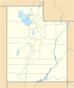
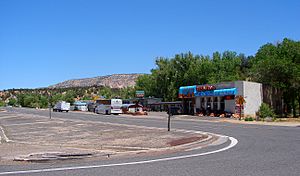
Mount Carmel Junction and Mount Carmel are two small communities in Utah, United States. They are not official towns but are close to some amazing places! You can find them about 12 miles (19 km) east of Zion National Park. They are also near the beautiful Coral Pink Sand Dunes State Park.
Mount Carmel Junction is where two important roads meet: U.S. Route 89 and State Route 9. Mount Carmel is just a mile (1.6 km) north of this junction. This area is part of the high desert, known as the Colorado Plateau.
Contents
History of Mount Carmel Junction
Early Settlers: The Virgin Anasazi
Long ago, around the 13th century, a group of people called the Virgin Anasazi lived in this area. They were the first settlers here. These people were farmers who mostly grew maize, also known as corn. You can still find signs of their presence in places like Parunuweap, which is the East Fork of the Virgin River.
Founding the Community
In 1864, a doctor named Priddy Meeks started a town called Winsor. This was part of a plan by Brigham Young to settle different parts of Utah Territory. More settlers arrived in 1865. However, conflicts with Native Americans forced them to leave the area.
Seven years later, in 1871, settlers returned and stayed for good. This time, they named the town Mount Carmel. This name honored a famous mountain in Palestine. In 1875, the community was growing, and people started building more permanent homes. Doctor Meeks later moved away and passed away at 91 years old.
The Morrison Family and the Junction
Only a few families settled directly in Mount Carmel Junction. One important family was Jack and Fern Morrison. Jack had a big idea: a road was needed to connect Zion Canyon to the east side of the park. He explored the area and realized the road should come down near what is now Mount Carmel Junction.
Jack used old wagon trails to find his way. The hills were so steep that he had to tie a cedar tree to the back of his Model-T-Ford to slow it down! In 1931, Jack was able to claim the land for his family. The land was tough, with many sandy areas and gullies. It also had dangerous flash floods. Sadly, Jack and Fern lost two of their children in a flash flood from the East Fork of the Virgin River. Jack passed away in 1961. Fern, a very strong woman, continued to build the community and lived to be 90 years old.
Artist Maynard Dixon's Home
Maynard Dixon was a famous artist known for his paintings of the American West. In 1939, he built a summer home in Mount Carmel Junction. After he passed away in 1946, his ashes were buried on a high bluff above his art studio.
John Wesley Powell's Exploration
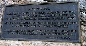
In 1872, explorer John Wesley Powell visited this area. He was the first European-American to travel down the East Fork of the Virgin River. This journey went from Mount Carmel Junction all the way to Shunesburg.
You can find a special plaque near the river that tells about his trip. It says that Powell named the canyon "Parunuweap." This word comes from the Paiute Indian language and means "roaring water canyon."
The Historic Rock Church
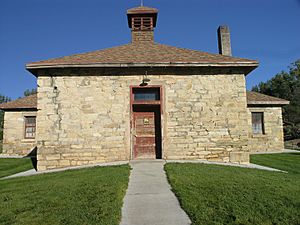
The Historic Rock Church in Mount Carmel has a long history. It was first built as a log building in 1880. It served as a church, a school, and a place for fun gatherings. In 1890, it was rebuilt using stone. The rocks for the building were brought by wagon from a hill about a mile away.
Later, a wooden part was added, making it a two-room school. The floors were eventually made of hardwood, which was great for dancing! In 1919, the building burned down. But in 1923, it was rebuilt again with strong rock. After that, it was mostly used as a church. The children who used to go to school there started riding in a covered wagon to a school in nearby Orderville. Today, the Historic Rock Church is listed on the National Register of Historic Places, meaning it's a very important historical site.
Zion-Mount Carmel Highway and Tunnel
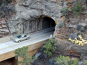
In 1919, Zion National Park was officially created. By 1923, people started looking for a way to connect Zion Canyon to the east side of the park. They looked at four different paths. The chosen route went up the side of Pine Creek canyon with many turns, through a long tunnel, and then along Clear Creek to the park's eastern edge. This road would then connect to U.S. Route 89 at Mount Carmel Junction.
Building the Zion-Mount Carmel Highway and the famous Zion-Mount Carmel Tunnel began in 1927. The tunnel was a huge engineering challenge for its time! Workers had to drill 5,613 feet (1,711 meters) through solid rock. On July 4, 1930, the tunnel and highway were officially opened. This new road made it much easier for people to visit Zion Canyon, as well as Grand Canyon National Park and Bryce Canyon National Park.
Geology of the Area
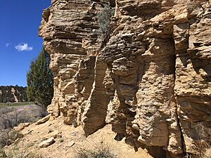
Mount Carmel Junction is surrounded by interesting geological features. About 2 miles (3.2 km) east of the main highway, you can find the Sevier Fault, a long crack in the Earth's crust. To the south, there are tall sandstone cliffs. You can also see the White Cliffs, which are part of the amazing Grand Staircase rock formations, to the east.
If you travel halfway between Mount Carmel Junction and Kanab, you'll discover the beautiful Coral Pink Sand Dunes. If you head north on U.S. Route 89, you'll see "hoodoo" formations. These are tall, thin rock spires, similar to those found in Bryce Canyon and Cedar Breaks. The Carmel Formation, a type of rock named after Mount Carmel, is also very visible in this area.
 | Laphonza Butler |
 | Daisy Bates |
 | Elizabeth Piper Ensley |


