
Kanab, Utah facts for kids
Quick facts for kids
Kanab, Utah
|
|
|---|---|

U.S. Route 89 through Kanab, March 2013
|
|
| Nickname(s):
Utah's Little Hollywood
|
|

Location in Kane County and the state of Utah
|
|

Location of Utah in the United States
|
|
| Country | United States |
| State | Utah |
| County | Kane |
| Settled | 1870 |
| Incorporated | 1935 |
| Founded by | Jacob Hamblin |
| Named for | Southern Paiute for 'willow' |
| Government | |
| • Type | Council-manager |
| Area | |
| • Total | 14.47 sq mi (37.48 km2) |
| • Land | 14.44 sq mi (37.39 km2) |
| • Water | 0.04 sq mi (0.09 km2) |
| Elevation | 4,970 ft (1,515 m) |
| Population
(2020)
|
|
| • Total | 4,683 |
| • Density | 323.64/sq mi (124.947/km2) |
| Time zone | UTC-7 (Mountain (MST)) |
| • Summer (DST) | UTC-6 (MDT) |
| ZIP code |
84741
|
| Area code(s) | 435 |
| FIPS code | 49-39920 |
| GNIS feature ID | 1429276 |
Kanab is a city in Utah, United States. It is the main city, or county seat, of Kane County. Kanab is located near the Arizona state line, right by Kanab Creek.
Contents
About Kanab, Utah
The area where Kanab is located was first settled in 1864. The town itself was started in 1870. This happened when 10 Mormon families moved there. The name "Kanab" comes from a Paiute word. It means "place of the willows." A fort was built here in 1864. It was used to explore the area. In 2020, about 4,683 people lived in Kanab.
Kanab is in a special area called the "Grand Circle." It is close to many amazing natural places. These include Vermilion Cliffs National Monument, Bryce Canyon National Park, and the North Rim of the Grand Canyon. Other nearby spots are Zion National Park and Lake Powell. You can also visit Grand Staircase–Escalante National Monument. There is also Coral Pink Sand Dunes State Park. The largest animal sanctuary in the U.S., Best Friends Animal Society, is also close by.

A sign welcoming you to Kanab calls it "The Greatest Earth on Show." This is because of all the amazing rock formations nearby.
Kanab: Little Hollywood
Locals call Kanab "Little Hollywood." This is because many movies and TV shows have been filmed here. A lot of these were western films. Some famous examples include Stagecoach (1939) and The Lone Ranger. Other shows like Gunsmoke and Daniel Boone were also filmed here. Even movies like Planet of the Apes (1968) used Kanab's scenery.
People of Kanab
| Historical population | |||
|---|---|---|---|
| Census | Pop. | %± | |
| 1890 | 409 | — | |
| 1900 | 710 | 73.6% | |
| 1910 | 733 | 3.2% | |
| 1920 | 1,102 | 50.3% | |
| 1930 | 1,195 | 8.4% | |
| 1940 | 1,397 | 16.9% | |
| 1950 | 1,287 | −7.9% | |
| 1960 | 1,645 | 27.8% | |
| 1970 | 1,381 | −16.0% | |
| 1980 | 2,148 | 55.5% | |
| 1990 | 3,289 | 53.1% | |
| 2000 | 3,564 | 8.4% | |
| 2010 | 4,312 | 21.0% | |
| 2020 | 4,683 | 8.6% | |
| U.S. Decennial Census | |||
In 2010, there were 4,312 people living in Kanab. There were 1,729 households. Most people were White (96.2%). About 4.2% of the population was Hispanic or Latino.
Many households were married couples living together. The average household had about 2.44 people. The average family had about 3.08 people. The average income for a family was around $48,008. A small number of people (5.6%) lived below the poverty line.
Kanab's Location and Weather
Kanab is located on the western Colorado Plateau. Main roads like US 89 and US 89A meet in the center of town. US 89 goes north to Orderville and southeast to Page, Arizona. US 89A goes south to Fredonia, Arizona.
The city covers about 14.47 square miles (37.48 square kilometers). Most of this is land. Kanab Creek flows south of the city. It eventually meets the Colorado River in the Grand Canyon.
Kanab has a semi-arid climate. This means it's generally dry. Spring, from April to June, is warm and sunny. Nights can still be cool, even in May. Summers have monsoon thunderstorms from July to October. Winters are mild during the day and cold at night. Kanab gets some snow, but the amount can change a lot each year.
| Climate data for Kanab, Utah 1991–2020, extremes 1899- | |||||||||||||
|---|---|---|---|---|---|---|---|---|---|---|---|---|---|
| Month | Jan | Feb | Mar | Apr | May | Jun | Jul | Aug | Sep | Oct | Nov | Dec | Year |
| Record high °F (°C) | 72 (22) |
77 (25) |
85 (29) |
90 (32) |
101 (38) |
107 (42) |
108 (42) |
106 (41) |
104 (40) |
94 (34) |
81 (27) |
74 (23) |
108 (42) |
| Mean daily maximum °F (°C) | 49.4 (9.7) |
54.0 (12.2) |
62.2 (16.8) |
69.2 (20.7) |
78.2 (25.7) |
89.7 (32.1) |
94.2 (34.6) |
91.5 (33.1) |
84.8 (29.3) |
72.7 (22.6) |
59.3 (15.2) |
48.5 (9.2) |
71.1 (21.8) |
| Mean daily minimum °F (°C) | 24.8 (−4.0) |
27.8 (−2.3) |
32.6 (0.3) |
37.3 (2.9) |
44.7 (7.1) |
52.5 (11.4) |
60.6 (15.9) |
59.5 (15.3) |
52.0 (11.1) |
41.2 (5.1) |
31.4 (−0.3) |
24.6 (−4.1) |
40.8 (4.9) |
| Record low °F (°C) | −20 (−29) |
−12 (−24) |
1 (−17) |
8 (−13) |
16 (−9) |
23 (−5) |
31 (−1) |
35 (2) |
24 (−4) |
9 (−13) |
−4 (−20) |
−12 (−24) |
−20 (−29) |
| Average precipitation inches (mm) | 1.71 (43) |
1.92 (49) |
1.40 (36) |
0.88 (22) |
0.59 (15) |
0.29 (7.4) |
1.25 (32) |
1.45 (37) |
1.62 (41) |
1.51 (38) |
0.97 (25) |
1.37 (35) |
14.96 (380.4) |
| Average snowfall inches (cm) | 5.4 (14) |
5.8 (15) |
1.8 (4.6) |
1.8 (4.6) |
0 (0) |
0 (0) |
0 (0) |
0 (0) |
0 (0) |
0.2 (0.51) |
1.8 (4.6) |
5.3 (13) |
22.1 (56.31) |
| Average precipitation days (≥ 0.01 inch) | 6.1 | 6.8 | 5.8 | 5.1 | 4.0 | 2.2 | 5.5 | 6.9 | 4.7 | 4.3 | 3.6 | 5.5 | 60.5 |
| Average snowy days (≥ 0.1 inch) | 2.0 | 2.0 | 1.0 | 0.7 | 0 | 0 | 0 | 0 | 0 | 0.2 | 1.6 | 2.3 | 9.8 |
| Source 1: NCEI | |||||||||||||
| Source 2: Nowdata | |||||||||||||
Transportation in Kanab
Kanab has its own airport, the Kanab Municipal Airport. It is used for general aviation. US 89 goes through the city. US 89A also starts and ends within the city limits.
Jackson Flat Reservoir

Construction on the Jackson Flat Reservoir started in 2010. It took two years to build and one year to fill with water. The reservoir helps provide water for local irrigation. It is located south of Kanab, near the airport.
During the building of the reservoir, workers found old Anasazi ruins. They even found human remains. Any sites that would be underwater were carefully dug up. The remains were given to the local Paiute tribe for proper care.
The Jackson Flat Reservoir is now a place for fun activities. You can go fishing for trout, catfish, and bluegill. You can also go boating (without motors), swim, or enjoy concerts and stargazing.
Interesting Stories and Wildlife
Search for Montezuma's Treasure
In 1914, a man named Freddy Crystal came to Kanab. He claimed that the great treasure of Montezuma, an ancient Aztec ruler, was hidden in the mountains around Kanab. Many people searched for this treasure. They even tried to drain a lake, thinking the treasure was in an underwater cave. However, the government stopped this plan. The lake was home to a rare snail, the Kanab ambersnail.
The Kanab Ambersnail
The Kanab ambersnail is a special type of snail. It is considered an endangered species. One of its only two natural homes is a wet meadow near Kanab called Three Lakes. This snail is very important to protect.
Notable People from Kanab
- LaVoy Finicum – born here
- Jacob Hamblin
- William Thomas Stewart
- Kelly Sweet
- Mary Elizabeth Woolley
Images for kids
-
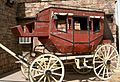
Wells Fargo U.S. Mail Service
-
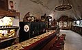
Moqui Cave
-

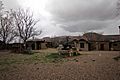
Parry Lodge, Historic Movie Motel
-
Little Hollywood Museum of Western Film
-
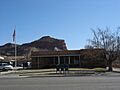
Kanab Post Office


See also
 In Spanish: Kanab (Utah) para niños
