
Markagunt Plateau facts for kids
Quick facts for kids Markagunt Plateau |
|
|---|---|
 |
|
| Highest point | |
| Naming | |
| English translation | "Highland of trees" |
| Language of name | Piute |
| Geography | |

Markagunt Plateau
Location in Utah
|
|
| Geology | |
| Last eruption | 1050 or before |
The Markagunt Plateau is a special area in southern Utah, United States. It's known for its many volcanoes and lava flows. This area was formed a long time ago by older volcanoes. Today, you can see several cinder cones (cone-shaped hills made of volcanic ash) and lava flows (rivers of melted rock).
Some of these lava flows have cool lava tubes, which are like underground tunnels. One famous one is Mammoth Cave. Other lava flows have blocked rivers, creating lava dams and beautiful lakes like Navajo Lake. Volcanoes here were active during the Pliocene and Pleistocene periods, which were millions of years ago. Some activity might have even continued into the Holocene (our current time period). Old stories from the Southern Paiute tribe might even describe these past eruptions.
Contents
Where is the Markagunt Plateau?
The Markagunt Plateau is located in southern Utah. It spreads across three counties: Iron County, Garfield County, and Kane County. To the west is Cedar City, and to the south is Kanab. You can drive through this volcanic area on Utah State Route 14, Utah State Route 143, and Utah State Route 148. Small towns like Duck Creek Village are also nearby.
The volcanic area sits on a high plateau. To the south, you'll see the Pink Cliffs, and to the west, the cliffs of Cedar Breaks National Monument. The plateau has many lava flows and more than 25 cinder cones. Most of these cones are found between Panguitch Lake and Navajo Lake. Some cones, like Hancock Peak, are very tall, reaching up to 150 meters (about 500 feet) high.
Amazing Lava Features
The lava flows on the Markagunt Plateau are often rough and blocky. They can have tall edges, sometimes 30 to 60 meters (100 to 200 feet) high. Many of these flows came out of long cracks in the ground called fissure vents. Some of the lava flows here are among the newest in Utah. These younger flows don't have much plant life growing on them yet. Older flows, however, have been cut by streams over time.
Bowers Cave and Mammoth Cave are cool lava tubes found in the lava flows. The Duck Creek Lava Tube is especially long, stretching about 3.7 kilometers (12,000 feet). That makes it one of the longest lava tubes in the United States! Inside these tubes, you can often find ice and pools of water all year round. You can usually get into them where parts of the roof have fallen in. Some lava flows even reach almost to Panguitch Lake.
The lava flows have also changed how water flows in the area. They blocked natural waterways, which created Navajo Lake. This lake is special because its water drains underground into two different river systems. Humans later built a dam to make the lake even bigger. Other lava-dammed lakes have since dried up and become meadows.
Because of the lava, water on the Markagunt Plateau often flows underground through sinkholes. These sinkholes form in limestone rocks. The lava flows, which let water pass through easily, likely helped these sinkholes develop. Many streams and creeks here start from springs or disappear into these sinkholes.
How the Markagunt Plateau Formed
Southwestern Utah sits where two major geological areas meet: the Colorado Plateau and the Basin and Range Province. The Colorado Plateau has flat layers of rock, while the Basin and Range Province has steep mountains and valleys.
For the last 5 million years, volcanoes have been active in this region. The Markagunt Plateau is part of a large block of land that is bordered by faults. The rocks under the volcanoes are made of different types of sedimentary and volcanic rocks. The volcanoes here are considered "intraplate," meaning they are not caused by hotspots or subduction (where one Earth plate slides under another).
What are the Rocks Made Of?
The volcanic rocks on the Markagunt Plateau vary a lot. They include different types of basalt and andesite. Over time, the rocks seem to have become more silica-rich. These rocks contain tiny crystals of minerals like olivine and plagioclase.
Climate and Nature
The Markagunt Plateau gets about 760 millimeters (30 inches) of rain each year. Most of this comes as snow from the Pacific Ocean. But there are also summer monsoon rains.
Most of the plateau is part of Dixie National Forest. You'll find trees like aspen, spruce, and fir here. Underneath the trees, there are plants like juniper and mountain gooseberry. Most of the land is covered in plants, except for the very youngest volcanoes and steep canyon walls. In wet areas called marshes, you might see plants like cattails. Juniper trees also grow on the lava flows.
-
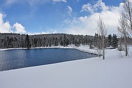
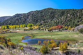
Duck Lake
-
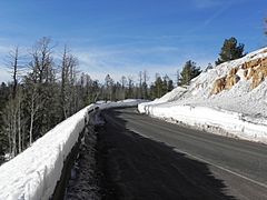
Utah State Route 14 near Navajo Lake
-
Duck Lake in autumn
-
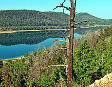
Navajo Lake
.jpg)

.jpg)
.jpg)
History of Eruptions
Volcanoes on the Markagunt Plateau have erupted in three main periods.
- The first period was between 5.3 and 2.8 million years ago. These older volcanoes are very worn down.
- The second period happened between 800,000 and 500,000 years ago. These volcanoes are somewhat eroded.
- The third and most recent period was during the middle Pleistocene and Holocene (our current time).
Here are some examples of past eruptions:
- Dickinson Hill: A cinder cone and lava flows from 5.3 million years ago.
- Houston Mountain: Lava flows from 5.3 million years ago.
- Blue Spring Mountain: A cone and lava flow from 2.78 million years ago.
- Horse Knoll: A cone and lava flows from 750,000 years ago.
- Asay Knoll, Bowers Knoll, Cooper Knoll, and Strawberry Knolls: These cinder cones and lava flows are all about 500,000 years old.
Recent Eruptions
.jpg)
Many volcanic features here look quite new. Scientists have used special dating methods to find out their ages. For example, some lava flows from Henrie Knolls are about 58,000 years old. Other flows from Miller Knoll are around 32,000 to 38,000 years old.
The exact date of the very last eruption isn't known for sure. However, eight cinder cones in the area seem to be less than 10,000 years old. The Southern Paiute tribe settled in this region after 1,100 AD. Their old stories might even contain memories of these recent lava flows.
Besides volcanoes, other natural processes have shaped the area. These include landslides, wind erosion, and river deposits. Beavers have also built beaver dams on streams. During the Pleistocene Ice Age, glaciers covered parts of the Markagunt Plateau, shaping the land and burying some lava flows.
Volcanic Safety
Big volcanic eruptions, like the one at Mount St. Helens in the 1980s, made people more aware of the dangers of volcanoes. While most serious dangers come from explosive volcanoes, even basaltic (less explosive) eruptions like those in Utah can be risky.
The Markagunt Plateau is considered a low-risk volcano. If it were to become active again, it could affect Navajo Lake, which is a popular spot for recreation. It could also impact roads like Utah State Route 14 and U.S. Route 89, which cross over old lava flows.
