
Page, Arizona facts for kids
Quick facts for kids
Page
|
||
|---|---|---|

View of Lake Powell Boulevard in Page
|
||
|
||
| Motto(s):
"The Center of Canyon Country"
|
||

Page, Arizona
Location in the United States
|
||
| Country | United States | |
| State | Arizona | |
| County | Coconino | |
| Government | ||
| • Type | Council-Manager | |
| Area | ||
| • Total | 38.33 sq mi (99.27 km2) | |
| • Land | 38.18 sq mi (98.89 km2) | |
| • Water | 0.15 sq mi (0.38 km2) | |
| Elevation | 4,101 ft (1,250 m) | |
| Population
(2020)
|
||
| • Total | 7,440 | |
| • Density | 194.86/sq mi (75.23/km2) | |
| Time zone | UTC−7 (MST) | |
| • Summer (DST) | UTC−7 (no PDT) | |
| ZIP codes |
86036, 86040
|
|
| Area code(s) | 928 | |
| FIPS code | 04-51810 | |
| GNIS feature ID | 2411352 | |
| Website | cityofpage.org | |

Page is a city in Coconino County, Arizona, United States. It is located near the famous Glen Canyon Dam and the beautiful Lake Powell. As of the 2020 census, about 7,440 people live in Page.
Contents
History of Page
How Page Was Founded
Page was started in 1957. It was built as a place for workers and their families to live. These workers were building the huge Glen Canyon Dam on the Colorado River. The land for the city, about 17 square miles (44 square kilometers), was traded with the Navajo Nation.
Location and Name
The city sits on top of Manson Mesa. It is about 4,300 feet (1,311 meters) above sea level. This is also about 600 feet (183 meters) higher than Lake Powell. At first, the city was called Government Camp. Later, it was named after John C. Page. He was a commissioner for the Bureau of Reclamation from 1936 to 1943.
After the Dam Was Built
The Glen Canyon Dam was finished in 1966. Page officially became a town on March 1, 1975. The city has grown steadily since then. Today, over 7,000 people call Page home.
Page as a Tourist Spot
New roads and a bridge were built for the dam's construction. These helped Page become a popular gateway. It is now the main entrance to the Glen Canyon National Recreation Area and Lake Powell. More than 3 million visitors come here every year.
Power Plants Near Page
Page is also home to large power plants. The Glen Canyon Dam can produce 1,288,000 kilowatts of electricity. Another power plant, the Navajo Generating Station, was to the southeast. It used coal to make 2,250,000 kilowatts. This plant stopped working in 2019. Its three tall smokestacks were taken down on December 18, 2020.
Antelope Canyon Tourism
In 1997, Antelope Canyon opened for visitors. This amazing natural slot canyon is on Navajo land next to Page. It was formed by water erosion over many years. Opening Antelope Canyon greatly increased tourism for Page.
Geography and Climate
Page's Location and Size
Page covers a total area of about 16.6 square miles (43 square kilometers). Almost all of this area is land. Only a tiny part, about 0.04 square miles (0.1 square kilometers), is water.
Climate in Page
Page has a very dry climate. This means it gets very little rain. Summers are hot and very dry. Winters are chilly, but there is very little snow. Page is on the southern edge of the Great Basin Desert. It is also part of the Colorado Plateau. The area is dry because it is in the rain shadow of mountains in California. It is also too far north to get regular summer storms called North American monsoons.
Population Information
| Historical population | |||
|---|---|---|---|
| Census | Pop. | %± | |
| 1960 | 2,960 | — | |
| 1970 | 1,439 | −51.4% | |
| 1980 | 4,907 | 241.0% | |
| 1990 | 6,598 | 34.5% | |
| 2000 | 6,809 | 3.2% | |
| 2010 | 7,247 | 6.4% | |
| 2020 | 7,440 | 2.7% | |
| U.S. Decennial Census | |||
In 2010, Page had 7,247 people living in 2,518 households. The average household had about 2.87 people. The average family had about 3.32 people.
The median age of people in Page was 32.5 years old. About 29.6% of the population was under 18 years old. About 9% of the population was 65 years or older.
Economy in Page
Top Employers
Here are the top employers in Page, based on a 2023 report:
| # | Employer | # of Employees |
|---|---|---|
| 1 | Aramark | 1,100 |
| 2 | Page Unified School District | 532 |
| 3 | Walmart | 222 |
| 4 | National Park Service | 200 |
| 5 | City of Page | 181 |
| 6 | Infinity of Page Home Health Services Llc | 150 |
| 7 | Banner Health | 135 |
| 8 | GSM Outdoors | 122 |
| 9 | Page Steel Inc | 87 |
| 10 | Canyonlands Community Health Care Inc | 77 |
Education in Page
Most of Page is served by the Page Unified School District. The public schools include Lake View Primary School, Desert View Intermediate School, Page Middle School, Page High School, Manson Mesa High School, and Tse Yaato High School. The Glen Canyon Outdoor Academy is the only charter school in the area. Some parts of Page are also in the Fredonia-Moccasin Unified School District.
Media and Entertainment
Radio Stations
- KNAD 91.7 NPR repeater station
- KXAZ 93.3 Page
- KPLD 105.1 Kanab
- KPGE 1340 AM
Newspaper and Movies
The Lake Powell Chronicle is the weekly newspaper for Page. The 2001 movie Evolution was filmed in Page.
Transportation in Page
Roads and Public Transit
Page is located on U.S. Route 89. Arizona State Route 98 goes east into the Navajo Reservation. Public transportation is offered by Helping Hands Agency. Their service, called Express, goes to nearby towns like Tuba City and Cameron. National Park Express offers a daily shuttle. It connects Page with Las Vegas and Grand Canyon Village.
Airport
Page Municipal Airport serves the city. It offers scheduled flights, charter services, and general aviation.
Notable People from Page
- Matt Haryasz, a professional basketball player
- Fred Keller, a politician
- Mary Antonia Wood, an artist
Images for kids
-

Satellite view of Page, Lake Powell, Glen Canyon Dam, and the Colorado River
-
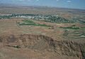
Aerial view of Page
-
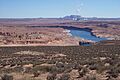
Colorado River with Page city area and the former Navajo Generating Station in the background


See also
 In Spanish: Page (Arizona) para niños
