Antelope Canyon facts for kids
Quick facts for kids Antelope Canyon |
|
|---|---|
| Tsé bighánílíní | |

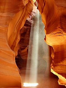
A beam of light in the weathered Upper Antelope Canyon (Tsé bighánílíní) in Navajo
|
|
| Floor elevation | 3,704 ft (1,129 m) |
| Length | Upper Antelope Canyon: about 660 feet (200 m) Lower Antelope Canyon: about 1,335 feet (407 m) |
| Depth | about 120 feet (37 m) |
| Geology | |
| Type | Sandstone slot canyon |
| Age | 8-60 million years |
| Geography | |
| Population centers | Page |
| Topo map | USGS Page |
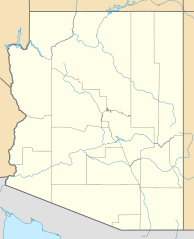
Antelope Canyon is a stunning natural wonder located in the American Southwest. It sits on Navajo land, near Lechee, Arizona. This special place is known for its incredible slot canyons. A slot canyon is a narrow gorge formed by water rushing through rock.
Antelope Canyon actually includes six beautiful slot canyon areas. These include Upper Antelope Canyon (also called The Crack) and Lower Antelope Canyon (known as The Corkscrew). It is a main attraction of the Lake Powell Navajo Tribal Park. You can also find a hiking trail to Rainbow Bridge National Monument nearby.
The Navajo people have their own names for these canyons. Upper Antelope Canyon is called Tsé bighánílíní. This means 'the place where water runs through the rocks'. Lower Antelope Canyon is known as Hazdistazí, or 'spiral rock arches'. Both canyons are part of the LeChee Chapter of the Navajo Nation. You can only visit them with a Navajo guide.
Contents
Discover Antelope Canyon: A Natural Wonder
Antelope Canyon is a truly unique place. It was formed over millions of years by the power of water and wind. Imagine water carving its way through solid rock!
How Antelope Canyon Was Formed
Antelope Canyon was created by the erosion of Navajo Sandstone. This happened mainly because of flash floods and other natural forces. When heavy rain falls, especially during the monsoon season, water rushes into the wide area above the canyon. It picks up speed and sand as it flows into the narrow canyon passages.
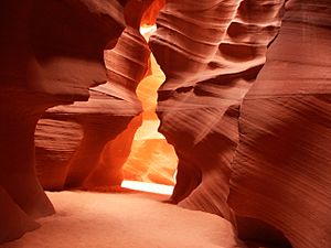
Over a very long time, this rushing water and sand slowly wore away the rock. This process deepened the corridors and smoothed the hard edges. The result is the beautiful, flowing shapes you see today. These shapes look like waves frozen in stone.
Exploring Antelope Canyon: Tours and Visits
Antelope Canyon is a very popular spot for visitors. It brings many tourists to the Navajo Nation. People have been able to visit with tours since 1983. In 1997, the Navajo Tribe made it a Navajo Tribal Park. This helped protect the area and manage visitors.
Besides the Upper and Lower areas, you can also visit other slot canyons. These include Rattle Snake Canyon, Owl Canyon, and Mountain Sheep Canyon. These are all part of the same water system as Antelope Canyon. Taking photos inside the canyons can be a bit challenging. This is because the light changes so much as it reflects off the canyon walls.
Upper Antelope Canyon: The Crack
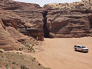
Upper Antelope Canyon is known as Tsé bighánílíní by the local Navajo people. It is the most visited part of Antelope Canyon. Its entrance and entire length are at ground level. This means no climbing is needed to enter. However, new Navajo rules require visitors to hike one way through the canyon. Then, they complete a moderate hike up and over the canyon through the desert to exit.
Visitors often see amazing beams of direct sunlight. These beams shine down from openings at the top of the canyon. They make the inside of the canyon glow with many colors. These light beams are most common in the summer. This is when the sun is high in the sky around midday. The light beams usually start appearing around March 20 and disappear by October 20 each year.
Lower Antelope Canyon: The Corkscrew
Lower Antelope Canyon is called Hazdistazí by the Navajo. This means 'spiral rock arches'. It is located a few miles from Upper Antelope Canyon. In the past, visiting this canyon meant climbing ladders. Now, metal stairways have been installed to help visitors.
Even with the stairways, the hike through Lower Antelope is more challenging than Upper Antelope. It is longer and narrower in some spots. The ground is not always flat. There are five flights of stairs to help you go down and come back up. At the end, you climb out using more stairs. Also, sand often falls from the crack above. This can make the stairs slippery.
Despite these challenges, many photographers love Lower Antelope Canyon. They often visit around midday when the light is best. Casual sightseers are less common here than in the Upper Canyon. The lower canyon has a "V" shape and is shallower than the Upper Antelope. The lighting is often best in the early morning and late morning hours.
Understanding Flash Floods and Safety
Antelope Canyon can only be visited with a guided tour. This is very important because of the danger of flash floods. Heavy rains during the monsoon season can quickly fill the canyon with water. These rains do not even have to fall directly on the canyon itself. Rain falling many miles away can funnel into the canyon with little warning.
On August 12, 1997, a flash flood occurred in Lower Antelope Canyon. Eleven visitors were tragically caught in the sudden floodwaters. This event led to major improvements in safety. At that time, the ladders were made of wood and were swept away. Today, strong metal ladder systems are bolted into place. Deployable cargo nets are also installed at the top of the canyon. There is also a NOAA Weather Radio and an alarm horn at the entrance. These systems help warn people of danger.
Even with these improved safety measures, the risk of injury from flash floods still exists. For example, on July 30, 2010, several tourists were stranded on a ledge during two flash floods in Upper Antelope Canyon. They were rescued, and some had to wait for the water to go down. While some people were injured, no lives were lost in that incident. These events remind us why guided tours and safety precautions are so important.
See also
 In Spanish: Cañón del Antílope para niños
 | James Van Der Zee |
 | Alma Thomas |
 | Ellis Wilson |
 | Margaret Taylor-Burroughs |


