Cameron, Arizona facts for kids
Quick facts for kids
Cameron, Arizona
|
|
|---|---|

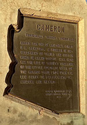
Cameron historic marker
|
|
| Country | United States |
| State | Arizona |
| County | Coconino |
| Area | |
| • Total | 18.74 sq mi (48.54 km2) |
| • Land | 18.72 sq mi (48.50 km2) |
| • Water | 0.02 sq mi (0.04 km2) |
| Elevation | 4,206 ft (1,282 m) |
| Population
(2020)
|
|
| • Total | 734 |
| • Density | 39.20/sq mi (15.14/km2) |
| Time zone | UTC-7 (MST) |
| • Summer (DST) | UTC-6 (MDT) |
| ZIP codes |
86016, 86020
|
| Area code | 928 |
| FIPS code | 04-09340 |
| GNIS feature ID | 2407943 |
Cameron (Navajo: Naʼníʼá Hasání) is a small community in Coconino County, Arizona, United States. It's located within the Navajo Nation. In 2020, about 734 people lived there.
Cameron's economy mostly relies on tourism. You'll find many food and craft stalls, restaurants, and other services for travelers. These travelers are usually driving between Flagstaff and Page. There's also a ranger station where you can get information and hiking permits for the Navajo Nation. The Navajo Nation also runs a large craft store in town.
The town is named after Ralph H. Cameron. He was one of the first two senators from Arizona to serve in the U.S. Congress when Arizona became a state.
Contents
Where is Cameron Located?
Cameron is found on the Navajo Nation in Arizona. It sits about 4,216 feet (1,285 meters) above sea level. The community is just south of the Little Colorado River. This is where the Little Colorado River Gorge begins, leading down towards the Grand Canyon.
Cameron is located right where two main roads meet: US 89 and State Route 64. It's also very close to the Desert View entrance of Grand Canyon National Park.
The total area of Cameron is about 18.7 square miles (48.5 square kilometers). Only a tiny part of this area is water.
Who Lives in Cameron?
| Historical population | |||
|---|---|---|---|
| Census | Pop. | %± | |
| 1960 | 20 | — | |
| 2000 | 978 | — | |
| 2020 | 734 | — | |
| U.S. Decennial Census | |||
In 2000, most people in Cameron spoke the Navajo language at home. About 70% of residents spoke Navajo, while 30% spoke English.
The population of Cameron has changed over the years. In 1940, there were 63 people. By 1960, the population was 20. In 2000, it grew to 978 people, and in 2020, it was 734.
Learning in Cameron
The Tuba City Unified School District serves the Cameron area. The community has one elementary school called Dzil Libei Elementary School. This school teaches students from kindergarten through 6th grade. The Navajo Nation also runs a local preschool.
Older students from Cameron attend Tuba City High School and Tuba City Elementary School.
Getting Around
If you need to travel from Cameron, there's a bus service called Express. It provides connecting bus service to Page.
Cool Places to See
Tanner's Crossing Bridge
One important historical site in Cameron is the Tanner's Crossing Bridge. This suspension bridge was built in 1911. It was made by the Midland Bridge Co. for the Office of Indian Affairs.
The bridge crosses a deep gorge of the Little Colorado River. It was only wide enough for one vehicle at a time. In 1959, a new road was built, and the bridge was no longer used for traffic.
The bridge is named after Seth Tanner. He was a Mormon prospector from Tuba City, Arizona. The Tanner's Crossing Bridge is so important that it was added to the National Register of Historic Places on June 5, 1986.
See also
In Spanish: Cameron (Arizona) para niños
 | Dorothy Vaughan |
 | Charles Henry Turner |
 | Hildrus Poindexter |
 | Henry Cecil McBay |


