
Tuba City, Arizona facts for kids
Quick facts for kids
Tuba City, Arizona
Tó Naneesdizí
|
|
|---|---|

Tuba Trading Post built in 1905
|
|

Location in Coconino County and the state of Arizona
|
|

Tuba City, Arizona
Location in Arizona

Tuba City, Arizona
Location in the United States
|
|
| Country | |
| State | |
| County | Coconino |
| Government | |
| • Type | Navajo chapter |
| Area | |
| • Total | 8.97 sq mi (23.24 km2) |
| • Land | 8.97 sq mi (23.24 km2) |
| • Water | 0.00 sq mi (0.00 km2) |
| Elevation | 4,918 ft (1,499 m) |
| Population
(2020)
|
|
| • Total | 8,072 |
| • Estimate
(2016)
|
N/A |
| Time zone | UTC-7 (MST) |
| • Summer (DST) | UTC-6 (MDT) |
| ZIP code |
86045
|
| Area code | 928 |
| FIPS code | 04-76010 |
| GNIS feature ID | 2409355 |
Tuba City (Navajo: Tó Naneesdizí) is a town in Coconino County, Arizona, located within the Navajo Nation. It is the second-largest community in Coconino County. In 2010, about 8,611 people lived there.
Tuba City is the biggest community in the Navajo Nation. It is also where the main office for the Western Navajo Agency is located. The Hopi village of Moenkopi is very close by. Most people in Tuba City are Navajo, but some Hopi people also live there.
The town was named by early European-American settlers. They honored a Hopi chief named Tuuvi. He became a Mormon and allowed these settlers to live in the area.
The Navajo name for the community, Tó Naneesdizí, means "tangled waters". This name likely comes from the many underground springs that feed the local water reservoirs.
Tuba City is found in the Painted Desert. It is near the western edge of the Navajo Nation. The town is about 50 miles (80 km) from the eastern entrance to Grand Canyon National Park. It is also about 78 miles (126 km) from Flagstaff.
Contents
History of Tuba City

People have lived in the Tuba City area for thousands of years. Spanish explorers first wrote about the area in 1776. Father Francisco Garcés noted that the Hopi people were growing crops there.
European-American settlers arrived in the late 1800s. They were part of the Mormon movement heading west. They named the town after Tuuvi, a Hopi man. He became a Mormon around 1870. Tuuvi invited the Mormons to settle near his village of Moenkopi.
The Tuba City Trading Post opened in 1870. It was a place for trade with the Navajo and Paiute people. These groups came to the area for its natural springs. The Hopi people were already living there. European-American Mormon settlers officially founded Tuba City in 1872.
Uranium Mining and Cleanup
In 1956, people started mining uranium near Tuba City. The Rare Metals Corporation opened an office and a mill there. This mill processed the uranium. The Atomic Energy Commission also had an office in town. The mill closed in 1966. At that time, there were no strong rules to protect people or the environment from mining waste.
The waste from the mill had high levels of radiation. It was dangerous for the environment. Cleanup of the mill site and waste piles finished in 1990. This made the area safer.
Healthcare in Tuba City
The Tuba City Regional Health Care Corporation hospital is in Tuba City. This hospital is a non-profit organization run by Native Americans. It employs about 1,200 people. The next closest hospital is in Flagstaff.
Geography and Climate

Tuba City covers an area of about 8.9 square miles (23 km2). All of this area is land.
The town is located within the Painted Desert. It is near the western edge of the Navajo Nation. You can reach Tuba City by U.S. Route 160. This road is close to the turn-off for Arizona State Route 264.
Tuba City is about 50 miles (80 km) from the eastern entrance to Grand Canyon National Park. It is also about 78 miles (126 km) from Flagstaff.
Time Zones
Arizona does not use Daylight Saving Time. However, the Navajo Nation does use it within its borders. This means that in Tuba City, some places follow Daylight Saving Time, and some do not. For example, tribal offices and schools observe Daylight Saving Time. Most private businesses follow Arizona's rule and do not change their clocks.
Weather in Tuba City
Tuba City has a cold desert climate. This means it has hot, dry summers. The summers are not as hot as in Phoenix, Arizona. Winters are cold and dry. It often freezes from October to April. There is usually not much snow in winter because the air is very dry.
Population and People
| Historical population | |||
|---|---|---|---|
| Census | Pop. | %± | |
| 1990 | 7,323 | — | |
| 2000 | 8,225 | 12.3% | |
| 2010 | 8,611 | 4.7% | |
| 2020 | 8,662 | 0.6% | |
| U.S. Decennial Census | |||
In 2020, Tuba City had 8,072 people living there. Most of the people (about 91.8%) are Native American. About 5.0% are White, and 1.2% are African American. A small number of people are Asian or Pacific Islander. About 0.7% of people are from two or more races. People of Hispanic or Latino origin made up 5.6% of the population.
The average age of people in Tuba City was 34.5 years old. About 26.7% of the population was under 18. About 6.6% were under 5 years old. More than half of the population (54.1%) was female.
The average income for a household was $57,045. About 23.1% of the people in Tuba City lived below the poverty line.
Languages Spoken
In 2000, many people in Tuba City spoke Navajo at home (61.2%). About 37.5% spoke English. A small number spoke Hopi (0.5%) or Spanish (0.8%).
Things to See and Do
- The Explore Navajo Interactive Museum opened in 2007. It is next to the old Tuba City Trading Post.
- The Hopi tribe's Tuuvi Travel Center opened in 2008. This large center cost $6.3 million to build. The Hopi Nation also plans to build a "Gateway to Hopiland" nearby.
-
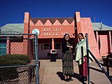
Tuba City Chapter House of the Navajo Nation.
-
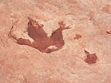
Dinosaur track in Tuba City
-
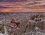
Coal Mine Canyon at sunset
-
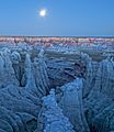
Moonrise at Coal Mine Canyon


Getting Around Tuba City
The town is served by U.S. Route 160. This road is near the junction with Arizona State Route 264.
Tuba City also has its own airport, the Tuba City Airport.
You can travel by bus using the Navajo Transit System. This system connects Tuba City to places like Flagstaff and Fort Defiance. The Hopi Senom Transit offers rides to Moenkopi. There is also an Express service that connects to Page.
Education in Tuba City
Students in Tuba City attend schools in the Tuba City Unified School District. There are also several schools run by tribes or the federal government. These include Tuba City High School.
Schools managed by the Bureau of Indian Education (BIE) include:
- Greyhills Academy High School (run by the tribe)
- Tuba City Boarding School (run by the BIE), which started in 1906.
Moencopi Day School (run by the tribe) is in nearby Moenkopi.
For higher education, there is the Diné College Tuba City Center.
Famous People from Tuba City
- Ethel Branch: A lawyer and politician.
- Mary Morez: An artist, born near Tuba City.
- Jonathan Nez: The ninth President of the Navajo Nation.
- Lori Piestewa: A soldier in the US Army. She was killed in Iraq in 2003. A mountain in Phoenix, Arizona, was renamed Piestewa Peak in her honor in 2008.
- Sunshine Sykes: A federal judge.
- Aaron Yazzie: A mechanical engineer who works at NASA's Jet Propulsion Laboratory. He was born in Tuba City.
- Quannah Chasinghorse: A model and activist for indigenous rights and climate change. She was born in Tuba City.
See also
 In Spanish: Tuba City (Arizona) para niños
