
Painted Desert (Arizona) facts for kids
Quick facts for kids Painted Desert |
|
|---|---|
 |
|

Relief map showing arc-shaped desert north and northeast of Mogollon Plateau and Mogollon Rim.
|
|
| Length | 160 miles |
| Area | 93500 acres |
| Naming | |
| Native name | Error {{native name}}: an IETF language tag as parameter {{{1}}} is required (help) |
| Geography | |
| Country | United States |
| State | Arizona |
| Borders on | Little Colorado and Puerco rivers |
The Painted Desert is a special place in the United States. It is located in the Four Corners area of Arizona. This desert is famous for its amazing, colorful hills and rocky landscapes. These areas are called badlands because they are hard to travel through.
You can find the Painted Desert near the eastern part of Grand Canyon National Park. It stretches southeast into Petrified Forest National Park. The easiest way to visit is through the northern part of Petrified Forest National Park. The desert gets its name from its bright colors. You'll see common red rocks, but also beautiful shades of purple and orange.
Contents
Discovering the Painted Desert
How the Desert Got Its Name
The Painted Desert was named a long time ago. In 1540, a Spanish explorer named Francisco Vázquez de Coronado led an expedition. He was looking for the legendary Seven Cities of Cibola. He found these cities about 40 miles (64 km) east of Petrified Forest National Park.
Coronado and his team hoped to find cities made of gold. When they didn't, he sent a group to find the Colorado River for supplies. As they traveled through this colorful land, they were amazed. They called the area El Desierto Pintado, which means "The Painted Desert" in Spanish.
Exploring the Desert Today
A large part of the Painted Desert is inside Petrified Forest National Park. This area is protected as Petrified Forest Wilderness. Here, you can only travel by foot; cars are not allowed. The park has many trails, from easy walks to longer hikes, where you can explore the colorful hills.
The Painted Desert also extends north into the Navajo Nation. If you want to explore off-road there, you need a special permit.
What Makes the Desert So Colorful?
The Rocks and Their Colors
The Painted Desert is made of many layers of rock. These layers include siltstone, mudstone, and shale. They are part of something called the Chinle Formation. These rocks are soft and wear away easily.
These fine rock layers contain tiny bits of iron and manganese. These minerals are like natural paints. They give the desert its many different colors. You can see reds, oranges, pinks, and even lavenders.
Ancient Forests and Fossils
Some parts of the desert have harder rock layers on top. These are thin layers of limestone and volcanic rock. They protect the flat-topped hills, called mesas. The Chinle Formation also has layers of volcanic ash. This ash is full of a material called silica.
Over millions of years, this silica helped turn ancient trees into petrified wood. You can find these fossilized logs all over the area. The wearing away of these rock layers has created the unique badlands landscape. In the southern parts of the desert, you can find fossilized remains of a coniferous forest from the Triassic period.
Wind, water, and soil keep changing the desert's look. They move sediment and uncover new layers of the Chinle Formation. Scientists have found many fossils of ancient plants and animals here. They have also found dinosaur tracks and signs that early humans lived in this region.
Size and Weather
Where the Desert Is Located
The Painted Desert stretches from towns like Cameron and Tuba City in the northwest. It goes southeast past Holbrook and into Petrified Forest National Park. The desert is about 120 miles (193 km) long and 60 miles (97 km) wide. This makes its total area around 7,500 square miles (19,425 km²).
To the southwest and south, the desert borders the Mogollon Plateau. The edge of this plateau is called the Mogollon Rim.
The Desert's Climate
The Painted Desert has a cold desert climate. This means it has hot, dry summers. The winters are chilly, but there is usually very little snow. This is because the Mogollon Rim blocks much of the rain.
The amount of rain the Painted Desert gets each year is very low. It's one of the driest places in northern Arizona.
| Climate data for Petrified Forest National Park, Arizona, 1991–2020 normals, extremes 1973–present | |||||||||||||
|---|---|---|---|---|---|---|---|---|---|---|---|---|---|
| Month | Jan | Feb | Mar | Apr | May | Jun | Jul | Aug | Sep | Oct | Nov | Dec | Year |
| Record high °F (°C) | 67 (19) |
73 (23) |
84 (29) |
89 (32) |
101 (38) |
103 (39) |
104 (40) |
101 (38) |
100 (38) |
90 (32) |
79 (26) |
69 (21) |
104 (40) |
| Mean maximum °F (°C) | 60.1 (15.6) |
67.8 (19.9) |
75.2 (24.0) |
82.1 (27.8) |
89.7 (32.1) |
98.9 (37.2) |
99.0 (37.2) |
96.1 (35.6) |
91.4 (33.0) |
82.6 (28.1) |
72.4 (22.4) |
62.7 (17.1) |
100.1 (37.8) |
| Mean daily maximum °F (°C) | 47.6 (8.7) |
52.5 (11.4) |
60.7 (15.9) |
68.4 (20.2) |
77.6 (25.3) |
88.6 (31.4) |
91.5 (33.1) |
88.4 (31.3) |
82.0 (27.8) |
70.5 (21.4) |
58.2 (14.6) |
46.5 (8.1) |
69.4 (20.8) |
| Daily mean °F (°C) | 35.0 (1.7) |
38.9 (3.8) |
45.4 (7.4) |
51.7 (10.9) |
60.6 (15.9) |
70.8 (21.6) |
75.5 (24.2) |
73.3 (22.9) |
66.6 (19.2) |
55.2 (12.9) |
43.1 (6.2) |
34.0 (1.1) |
54.2 (12.3) |
| Mean daily minimum °F (°C) | 22.3 (−5.4) |
25.3 (−3.7) |
30.1 (−1.1) |
35.0 (1.7) |
43.6 (6.4) |
52.9 (11.6) |
59.6 (15.3) |
58.3 (14.6) |
51.3 (10.7) |
39.9 (4.4) |
28.1 (−2.2) |
21.5 (−5.8) |
39.0 (3.9) |
| Mean minimum °F (°C) | 5.1 (−14.9) |
9.9 (−12.3) |
17.4 (−8.1) |
24.2 (−4.3) |
31.2 (−0.4) |
43.9 (6.6) |
53.3 (11.8) |
52.4 (11.3) |
40.5 (4.7) |
26.1 (−3.3) |
14.9 (−9.5) |
8.2 (−13.2) |
4.1 (−15.5) |
| Record low °F (°C) | −7 (−22) |
−5 (−21) |
8 (−13) |
16 (−9) |
24 (−4) |
31 (−1) |
38 (3) |
46 (8) |
30 (−1) |
11 (−12) |
−3 (−19) |
2 (−17) |
−7 (−22) |
| Average precipitation inches (mm) | 0.93 (24) |
0.65 (17) |
0.70 (18) |
0.39 (9.9) |
0.46 (12) |
0.26 (6.6) |
1.36 (35) |
1.74 (44) |
1.12 (28) |
0.96 (24) |
0.62 (16) |
0.76 (19) |
9.95 (253.5) |
| Average snowfall inches (cm) | 0.7 (1.8) |
0.1 (0.25) |
0.2 (0.51) |
0.2 (0.51) |
0.0 (0.0) |
0.0 (0.0) |
0.0 (0.0) |
0.0 (0.0) |
0.0 (0.0) |
0.0 (0.0) |
0.3 (0.76) |
0.1 (0.25) |
1.6 (4.08) |
| Average precipitation days (≥ 0.01 in) | 4.3 | 4.3 | 4.3 | 3.1 | 3.3 | 2.1 | 8.0 | 8.6 | 5.6 | 4.8 | 4.2 | 5.0 | 57.6 |
| Average snowy days (≥ 0.1 in) | 0.4 | 0.2 | 0.1 | 0.1 | 0.0 | 0.0 | 0.0 | 0.0 | 0.0 | 0.0 | 0.3 | 0.5 | 1.6 |
| Source 1: NOAA | |||||||||||||
| Source 2: National Weather Service (mean maxima/minima 2006–2020) | |||||||||||||
Getting Around the Painted Desert
Many parts of the Painted Desert can only be reached by walking. Some areas have unpaved roads. However, major highways and paved roads cross through the region.
The towns of Cameron and Tuba City are two main places to visit. Both are located on the Navajo Nation. Remember, if you want to travel on backroads within the Navajo Nation, you will need a permit.
Images for kids
-
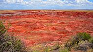
The Painted Desert, Petrified Forest National Park
-
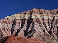
The gray and red colored bands across the landform are typical of most geologic features in the Painted Desert.
-
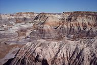
Painted Desert with logs of petrified wood, Petrified Forest National Park


See also
 In Spanish: Desierto Pintado para niños
