
Holbrook, Arizona facts for kids
Quick facts for kids
Holbrook
|
||
|---|---|---|

Historic Navajo County Courthouse and Museum
|
||
|
||
| Motto(s):
"Gateway to the Petrified Forest"
|
||

Location of Holbrook in Navajo County, Arizona
|
||

Holbrook, Arizona
Location in the United States
|
||
| Country | United States | |
| State | Arizona | |
| County | Navajo | |
| Incorporated | 1917 | |
| Government | ||
| • Type | Council-Manager | |
| • Body | Holbrook City Council | |
| Area | ||
| • Total | 17.37 sq mi (44.99 km2) | |
| • Land | 17.34 sq mi (44.92 km2) | |
| • Water | 0.03 sq mi (0.07 km2) | |
| Elevation | 5,076 ft (1,547 m) | |
| Population
(2020)
|
||
| • Total | 4,858 | |
| • Density | 280.10/sq mi (108.15/km2) | |
| Time zone | UTC-7 (MST (no DST)) | |
| ZIP code |
86025
|
|
| Area code(s) | 928 | |
| FIPS code | 04-33280 | |
| GNIS ID(s) | 2410773 | |
| Airport | Holbrook Municipal Airport | |
| Website | www.holbrookaz.gov | |

Holbrook (Navajo: Tʼiisyaakin) is a city in Navajo County, Arizona, United States. In 2020, about 4,858 people lived there. Holbrook is the main government center, or county seat, for Navajo County.
The city was started around 1881 or 1882. This was when the railroad was being built through the area. Holbrook was named after Henry Randolph Holbrook, who was the first chief engineer for the Atlantic and Pacific Railroad.
Contents
History of Holbrook
The area around Holbrook was first home to ancient people called Ancestral Puebloans. Later, the Puebloans, Navajo, and Apache tribes lived there.
In 1540, a Spanish explorer named Coronado traveled through the region. He was looking for the legendary Seven Cities of Cibola. Coronado sent a group west to find the Colorado River. They crossed the Little Colorado River about 25 miles (40 km) east of Holbrook. There, they discovered a colorful landscape they called "El Desierto Pintada," which means "The Painted Desert." The Hopi people then guided the explorers to the Grand Canyon.
Early American Settlements
After the Mexican–American War ended in 1848, this land became part of the United States. Between 1851 and 1857, the U.S. Army explored the area. One expedition, led by Lt. Beale, built a 10-foot (3 m) wide wagon road.
The area was first known as Navajo Springs. This was because of a spring about 12 miles (19 km) northeast of Holbrook. Soon, a store and a saloon opened near where the Rio Puerco and Little Colorado Rivers meet. This spot became known as Horsehead Crossing.
In 1876, Mormon settlers from Utah started new communities near Horsehead Crossing. They settled along both the Little Colorado and Rio Puerco rivers.
The Railroad and Ranching Era
In 1881 and 1882, railroad tracks were laid, and a train station was built. This station helped supply wood and water. It also shipped supplies south to Fort Apache. The community was then named Holbrook.
The railroad company sold a huge area of land to a group of investors from Boston. This group started the Aztec Land & Cattle Company. It was also known as the Hashknife Outfit. This company leased even more government land. It became one of the largest cattle ranches ever. Holbrook became the main office for the Hashknife Outfit. The town quickly grew into a busy "cow-town."
Wild West Times
The Hashknife Outfit hired many cowboys. Some of these cowboys were wanted by the law. Stealing cattle and horses was a big problem across the ranch's two million acres. Cowboys, sheep herders, farmers, and outlaws all wanted the same land. This led to a conflict known as the Pleasant Valley War or Tonto Basin War. Many people died in this range war.
Many events of the Pleasant Valley War happened in and around Holbrook until 1887. This included the famous Holbrook Shootout.
The Holbrook Shootout
On September 4, 1887, Commodore Perry Owens was the Sheriff of Apache County. He came to Holbrook to arrest Andy Blevins, also known as Andy Cooper. Blevins was wanted for stealing horses. He had also bragged about killing two men and had killed others, including two lawmen.
Sheriff Owens decided to face the Blevins brothers alone. He knew there would likely be a gunfight. He went to the Blevins' house, which is still standing today. Owens knocked on the door. When Blevins asked what he wanted, Owens said he was there to arrest him. Blevins fought back, and a shootout began. Blevins, two of his brothers, a friend, and Blevins' horse were all shot. Everyone died except one brother.
Owens was not hurt, even though people shot at him from only a few feet away. Owens fighting four men by himself made him a legend of the Old West. He became as famous as other lawmen like the Earp Brothers and Texas John Slaughter.
Holbrook's Growth and Changes
Holbrook was once called "the town too tough for women and churches." In 1914, it was said to be the only county seat in the U.S. without a church. The original train station was replaced by the Santa Fe Depot in 1892.
Navajo County was created from Apache County in 1895. Holbrook became its county seat. Many lawmen and cowboys from the area joined Theodore Roosevelt's Rough Riders in the late 1800s. By 1902, the Hashknife Outfit went out of business. Its land was sold to the Babbitt brothers.
In 1906, President Roosevelt made the Petrified Forest a National Monument. This included part of the Painted Desert. Holbrook officially became a city in 1917. Most of the old Beale Wagon Road became Route 66 in 1926. This famous road passed through both the Petrified Forest and Holbrook. Tourism then became a very important part of the city's economy.
The Holbrook Meteorite

Arizona is famous for its huge Meteor Crater. But Holbrook also had its own smaller meteorite event. On the evening of July 19, 1912, a smoke trail appeared in the sky. Soon after, at 7:15 p.m., a meteorite exploded high in the air. It was estimated to weigh about 419 pounds (190 kg).
About 16,000 or more small pieces of the meteorite rained down. They fell over Navajo County, about 6 miles (9.7 km) east of Holbrook. The main explosion was heard at least 40 miles (64 km) away. Pauline McCleve, who was 17 years old in Holbrook, said it was the loudest sound she had ever heard. The largest piece of the Holbrook Meteorite found weighed 14.5 pounds (6.6 kg). It is now at Arizona State University in Tempe. Scientists found that the Holbrook meteorite was a type of stony meteorite called a chondrite.
Geography and Climate
Holbrook covers a total area of about 15.4 square miles (40 km²). All of this area is land.
Holbrook has a cold desert climate. This means it has cold winters and hot summers. Even though some snow falls, most winters do not have much snow. The temperature can change a lot between day and night throughout the year.
Population and People
| Historical population | |||
|---|---|---|---|
| Census | Pop. | %± | |
| 1890 | 206 | — | |
| 1910 | 609 | — | |
| 1920 | 1,206 | 98.0% | |
| 1930 | 1,115 | −7.5% | |
| 1940 | 1,184 | 6.2% | |
| 1950 | 2,336 | 97.3% | |
| 1960 | 3,438 | 47.2% | |
| 1970 | 4,759 | 38.4% | |
| 1980 | 5,785 | 21.6% | |
| 1990 | 4,686 | −19.0% | |
| 2000 | 4,917 | 4.9% | |
| 2010 | 5,053 | 2.8% | |
| 2020 | 4,858 | −3.9% | |
| U.S. Decennial Census | |||
In 2000, there were 4,917 people living in Holbrook. There were 1,626 households, and 1,195 families. About 40.7% of households had children under 18 living with them. The average household had about 2.93 people.
The population was spread out by age. About 35.7% of people were under 18 years old. About 8.7% were 65 years or older. The average age was 30 years old.
Fun Places to Visit

- Petrified Forest National Park is about 28 miles (45 km) east of Holbrook. It is the closest city to the park.
- The Navajo County Courthouse is in downtown Holbrook. It was built in 1898. Today, it is used by the Navajo County Historical Society. It is also listed on the National Register of Historic Places.
- The Wigwam Motel is on Hopi Drive. It was built in 1950. You can sleep in a teepee-shaped room there! It is also on the National Register of Historic Places.
- The historic U.S. Route 66 runs right through Holbrook.
- Bucket of Blood Street was once named one of the "wackiest street names."
Education in Holbrook
Holbrook has schools for students of all ages.
Primary and Secondary Schools
The Holbrook Unified School District serves about 2,324 students.
- Park Elementary School teaches kindergarten through 2nd grade.
- Hulet Elementary School teaches 3rd through 5th grade.
- Indian Wells Elementary serves students in kindergarten through 6th grade in the northern part of the school district.
- Holbrook Junior High School serves students in 6th through 8th grade.
- Holbrook High School serves students in 9th through 12th grade.
A small part of Holbrook is also served by the Joseph City Unified School District.
Colleges and Universities
Northland Pioneer College has one of its four main campuses in Holbrook. This is a community college. Its other campuses are in Show Low, Snowflake, and Winslow.
Public Libraries
The Holbrook Public Library is located in the city.
Getting Around Holbrook

Greyhound Lines buses stop in Holbrook. These buses travel on their route between Los Angeles and New York. The White Mountain Connection bus service connects Holbrook with Show Low.
Holbrook is a meeting point for several major roads. These include Interstate 40, U.S. Route 180, and Arizona State Route 77. Arizona State Route 377 also connects with Arizona State Route 77 at the southern edge of Holbrook.
Famous People from Holbrook
- Mike Budenholzer, a basketball coach for the Phoenix Suns
- Chester Crandell, a politician
- Gene Evans, an actor
- Eric B. Shumway, a former president of Brigham Young University–Hawaii
- Aaron Yazzie, a mechanical engineer who works at NASA's Jet Propulsion Laboratory
Nearby Cities and Towns
Images for kids
-
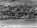
Downtown Holbrook, 1940s
-
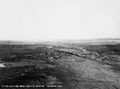
View of Holbrook, 1940s


See also
 In Spanish: Holbrook (Arizona) para niños
