
Arizona State Route 77 facts for kids
Quick facts for kids
|
||||
|---|---|---|---|---|
|
SR 77 highlighted in red
|
||||
| Route information | ||||
| Maintained by ADOT | ||||
| Length | 253.93 mi (408.66 km) | |||
| Existed | May 13, 1930–present | |||
| History | Part of the route is a former section of US 80 and US 89 | |||
| Tourist routes |
||||
| Major junctions | ||||
| South end | ||||
| North end | ||||
| Location | ||||
| Counties: | Pima, Pinal, Gila, Navajo | |||
| Highway system | ||||
| State routes in Arizona Unconstructed • Former
|
||||

State Route 77 (or SR 77) is a main highway in Arizona. It runs for a long distance across the state. The highway starts near the Navajo Nation boundary, north of Holbrook. It ends at I-10 in Tucson.
Contents
What is State Route 77 Like?
In the southern part of Tucson, SR 77 is known as Oracle Road. For the last mile and a half, it turns west towards Interstate 10 and is called Miracle Mile Road. This name was given in 1962.

North of the Navajo Nation boundary, SR 77 changes into BIA Route 6. This road goes north towards Keams Canyon. Between Show Low and Globe, SR 77 shares its path with U.S. Route 60. This means they are the same road for a while.
The southernmost parts of SR 77 used to be sections of U.S. Route 80 and U.S. Route 89. The very end part, Miracle Mile, was once part of Business 10 and State Route 84.
Why is it Called Tucson's Miracle Mile?

For many years, people thought Tucson's Miracle Mile got its name from a magazine article in 1937. But a historian named David Leighton found out the real story in 2015.
In 1936, a real estate developer named Stanley Williamson had an idea. He wanted to create a shopping area outside of Tucson's busy downtown. He got his idea from the Miracle Mile in Los Angeles, California.
The Los Angeles Miracle Mile was the idea of a real estate agent named A.W. Ross. He noticed that downtown Los Angeles was too crowded. More and more people were buying cars. Ross thought, "What if people could drive a bit further to shop?" He bought farmland along Wilshire Boulevard, a few miles from downtown. He believed that if people had cars, they would be happy to drive further to avoid traffic and find easy parking.
At first, no one thought his idea would work. But over time, many stores opened in his new business area. The Miracle Mile in Los Angeles became a very popular shopping district. Ross first called his area the Wilshire Boulevard Center. It was renamed the Miracle Mile in 1928. Tucson's Miracle Mile was inspired by this success story.
History of State Route 77
SR 77 was officially created on May 13, 1930. At first, it ran from McNary to U.S. Route 66 (US 66) in Holbrook. It passed through Show Low.
On June 20, 1938, the part of SR 77 between Show Low and McNary was removed. This happened after US 60 was finished. US 60 ran from Globe to Springerville through Show Low.
Then, SR 77 was extended southwest along the new US 60 to Globe. It was extended even further southeast along US 70 from Globe to Cutter. From Cutter, SR 77 went even further south. It ended at a meeting point with US 80 and US 89 in Oracle Junction. Back then, both US 80 and US 89 made up the road between Tucson and Oracle Junction.
In 1977, US 80 was removed from the Tucson to Oracle Junction area. It was shortened to end at I-10 in Benson.
On August 21, 1992, US 89 was also shortened. It ended at US 180 in Flagstaff. At the same time, the northern Tucson part of the Interstate 10 Business Loop was removed. This business loop started at I-10 and Miracle Mile. It went east on Miracle Mile to US 89. Then it followed US 89 south on Oracle Road.
SR 77 was immediately extended south. It took over the former US 89 path down Oracle Road to Miracle Mile in Tucson. Then it went west along Miracle Mile, which was part of the old I-10 Business Loop. It ended at an interchange with I-10. The rest of the old I-10 Business and US 89 was no longer a state highway. It was given to the city of Tucson on October 15, 1993.
Images for kids
-
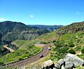
SR 77 traveling through Salt River Canyon
-
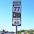
Between Miracle Mile and SR 79, SR 77 is part of Historic U.S. Route 80.
See also
 In Spanish: Ruta Estatal de Arizona 77 para niños
