Benson, Arizona facts for kids
Quick facts for kids
Benson, Arizona
|
||
|---|---|---|
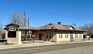
Benson Visitor Center, replica of former Benson Southern Pacific Railroad Station (2024)
|
||
|
||
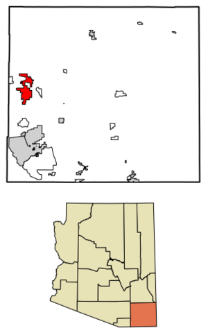
Location within Cochise County and Arizona
|
||
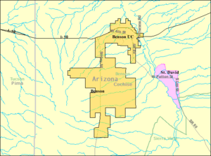
Detailed map of Benson
|
||
| Country | United States | |
| State | Arizona | |
| County | Cochise | |
| Founded | 1880 | |
| Government | ||
| • Type | Council-manager | |
| Area | ||
| • Total | 41.69 sq mi (107.97 km2) | |
| • Land | 41.64 sq mi (107.84 km2) | |
| • Water | 0.05 sq mi (0.13 km2) | |
| Elevation | 4,229 ft (1,289 m) | |
| Population
(2020)
|
||
| • Total | 5,355 | |
| • Density | 128.448/sq mi (49.597/km2) | |
| Time zone | UTC-7 (MST (no daylight saving time)) | |
| ZIP code |
85602
|
|
| Area code | 520 | |
| FIPS code | 04-05770 | |
| GNIS ID | 2409835 | |
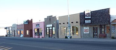
Benson is a city in Cochise County, Arizona, in the United States. In 2020, about 5,355 people lived there. The city was started as a train station area. It is located about 45 miles (72 km) east-southeast of Tucson.
Contents
History of Benson
Benson was founded in 1880. This happened when the Southern Pacific Railroad built its tracks through the area. The city was named after Judge William S. Benson. He was a friend of Charles Crocker, who was the president of the Southern Pacific Railroad.
The railroad chose Benson as a place to cross the San Pedro River. Benson then became an important spot for trains. It helped transport ore and metal from nearby mines. These mines were in places like Tombstone and Bisbee. Wagons would bring the mined materials to Benson. From there, they were shipped out by train.
For example, Benson was the closest train connection to Tombstone. This was true until 1882, when a smaller train line was built. This new line connected Benson to Contention City.
The train station in Benson was built near a well-known river crossing. This crossing was used by early travelers and mail routes. There was already a wagon depot there since 1871. In 1878, a toll bridge was built. This bridge helped move mining supplies to new towns like Fairbank and Tombstone. Two years later, this bridge was where the railroad bridge was built, marking the start of Benson.
Later, in the 1920s, a company called Apache Nitrogen Products started. It was located just outside Benson. This company was a major employer for many people in the area. Some houses built for the company's managers are now on the National Register of Historic Places.
Today, Benson is often known as the main entry point to Kartchner Caverns State Park. It is also home to the famous Singing Wind Bookshop. This shop specializes in books about the Southwest region.
Geography and Climate
Benson covers a total area of about 41.69 square miles (107.97 km²). Only a very small part of this area is water.
Benson's Climate
Benson is like other desert areas in Arizona. It does not get much rain and is usually hot. Sometimes, a little snow falls in the winter. The temperature can change a lot between day and night. This is especially true in months like October.
| Climate data for Benson, Arizona, 1991–2020 normals, extremes 1894–present | |||||||||||||
|---|---|---|---|---|---|---|---|---|---|---|---|---|---|
| Month | Jan | Feb | Mar | Apr | May | Jun | Jul | Aug | Sep | Oct | Nov | Dec | Year |
| Record high °F (°C) | 85 (29) |
90 (32) |
95 (35) |
102 (39) |
108 (42) |
116 (47) |
112 (44) |
113 (45) |
108 (42) |
103 (39) |
93 (34) |
84 (29) |
116 (47) |
| Mean maximum °F (°C) | 75.4 (24.1) |
79.0 (26.1) |
85.6 (29.8) |
91.8 (33.2) |
99.2 (37.3) |
105.4 (40.8) |
105.6 (40.9) |
102.4 (39.1) |
99.2 (37.3) |
93.9 (34.4) |
83.1 (28.4) |
76.6 (24.8) |
107.0 (41.7) |
| Mean daily maximum °F (°C) | 64.7 (18.2) |
68.0 (20.0) |
74.4 (23.6) |
81.4 (27.4) |
89.7 (32.1) |
99.0 (37.2) |
97.5 (36.4) |
95.2 (35.1) |
92.0 (33.3) |
84.2 (29.0) |
73.3 (22.9) |
64.4 (18.0) |
82.0 (27.8) |
| Daily mean °F (°C) | 45.9 (7.7) |
49.1 (9.5) |
54.8 (12.7) |
61.2 (16.2) |
69.2 (20.7) |
78.3 (25.7) |
81.7 (27.6) |
80.0 (26.7) |
75.1 (23.9) |
64.6 (18.1) |
53.5 (11.9) |
45.7 (7.6) |
63.3 (17.4) |
| Mean daily minimum °F (°C) | 27.1 (−2.7) |
30.1 (−1.1) |
35.3 (1.8) |
41.0 (5.0) |
48.7 (9.3) |
57.7 (14.3) |
65.9 (18.8) |
64.8 (18.2) |
58.1 (14.5) |
45.1 (7.3) |
33.6 (0.9) |
26.9 (−2.8) |
44.5 (7.0) |
| Mean minimum °F (°C) | 16.8 (−8.4) |
19.4 (−7.0) |
23.5 (−4.7) |
29.9 (−1.2) |
38.0 (3.3) |
47.1 (8.4) |
56.8 (13.8) |
58.1 (14.5) |
48.4 (9.1) |
31.9 (−0.1) |
21.1 (−6.1) |
16.3 (−8.7) |
13.4 (−10.3) |
| Record low °F (°C) | 5 (−15) |
4 (−16) |
10 (−12) |
18 (−8) |
22 (−6) |
35 (2) |
46 (8) |
42 (6) |
35 (2) |
15 (−9) |
9 (−13) |
−7 (−22) |
−7 (−22) |
| Average precipitation inches (mm) | 0.80 (20) |
0.63 (16) |
0.57 (14) |
0.19 (4.8) |
0.17 (4.3) |
0.29 (7.4) |
2.65 (67) |
2.79 (71) |
1.64 (42) |
0.65 (17) |
0.51 (13) |
0.88 (22) |
11.77 (298.5) |
| Average snowfall inches (cm) | 0.2 (0.51) |
0.0 (0.0) |
0.0 (0.0) |
0.0 (0.0) |
0.0 (0.0) |
0.0 (0.0) |
0.0 (0.0) |
0.0 (0.0) |
0.0 (0.0) |
0.0 (0.0) |
0.0 (0.0) |
0.0 (0.0) |
0.2 (0.51) |
| Average precipitation days (≥ 0.01 in) | 3.8 | 4.3 | 2.8 | 1.6 | 1.6 | 2.4 | 10.2 | 11.3 | 5.3 | 2.7 | 2.7 | 3.9 | 52.6 |
| Average snowy days (≥ 0.1 in) | 0.1 | 0.0 | 0.0 | 0.0 | 0.0 | 0.0 | 0.0 | 0.0 | 0.0 | 0.0 | 0.0 | 0.1 | 0.2 |
| Source 1: NOAA | |||||||||||||
| Source 2: National Weather Service | |||||||||||||
People of Benson (Demographics)
| Historical population | |||
|---|---|---|---|
| Census | Pop. | %± | |
| 1890 | 348 | — | |
| 1910 | 1,035 | — | |
| 1920 | 825 | −20.3% | |
| 1930 | 925 | 12.1% | |
| 1940 | 962 | 4.0% | |
| 1950 | 1,440 | 49.7% | |
| 1960 | 2,494 | 73.2% | |
| 1970 | 2,839 | 13.8% | |
| 1980 | 4,190 | 47.6% | |
| 1990 | 3,824 | −8.7% | |
| 2000 | 4,711 | 23.2% | |
| 2010 | 5,105 | 8.4% | |
| 2020 | 5,355 | 4.9% | |
| U.S. Decennial Census | |||
Benson first appeared in the U.S. Census in 1890. It was a small village back then. It officially became a town in 1924. Later, in 1985, voters decided to make Benson a city.
In 2000, there were 4,711 people living in Benson. There were 2,084 households, which are groups of people living together. About 18.9% of these households had children under 18. Many households (51.5%) were married couples.
Most people in Benson (89.3%) were White or European American. About 19.9% of the population identified as Hispanic or Latino.
The average age of people in Benson was 50 years old. About 19.5% of the population was under 18. A large group, 29.3%, was 65 years or older.
Education in Benson
The Benson Unified School District serves students from kindergarten to 12th grade. Their school mascot is the Benson Bobcat.
Cochise College also has a campus located on Route 90 in Benson.
Getting Around Benson (Transportation)
Benson has its own airport, Benson Airport. It is about 5 miles (8 km) northwest of the city center.
Interstate 10 runs through Benson. This highway can take you to Tucson, which is about 45 miles (72 km) northwest. It also goes to Willcox, about 35 miles (56 km) northeast.
Other important roads include Arizona State Route 80. This road goes southeast to Tombstone. Arizona State Route 90 goes south to Sierra Vista.
For train travel, Amtrak has a station in Benson. You can catch the Sunset Limited and Texas Eagle trains there. Freight trains, run by Union Pacific Railroad and the San Pedro and Southwestern Railroad, also serve Benson.
If you need a bus, Greyhound stops in Benson. There is also a local bus service called Benson Area Transit (BAT). It covers Benson and nearby towns like St. David and Pomerene.
Famous People from Benson
- Baxter Black, a cowboy, poet, and philosopher
- Lupe Diaz, a politician in the Arizona House of Representatives
- Nick Gomez, an actor
- Mitch Hoopes, a former NFL punter
- Harry Partch, a composer and creator of musical instruments
- Nick Ramus, an actor
- Jack Speiden, a stockbroker and ranch owner
- Chuck Stevenson, a racecar driver
See also
 In Spanish: Benson (Arizona) para niños
 | Janet Taylor Pickett |
 | Synthia Saint James |
 | Howardena Pindell |
 | Faith Ringgold |


