
McNary, Arizona facts for kids
Quick facts for kids
McNary, Arizona
|
|
|---|---|

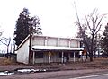
1900 McNary General Store
|
|

Location in Apache County and the state of Arizona
|
|

McNary, Arizona
Location in the United States
|
|
| Country | United States |
| State | Arizona |
| Counties | Apache, Navajo |
| Area | |
| • Total | 5.75 sq mi (14.88 km2) |
| • Land | 5.67 sq mi (14.69 km2) |
| • Water | 0.07 sq mi (0.19 km2) |
| Elevation | 7,363 ft (2,244 m) |
| Population
(2020)
|
|
| • Total | 484 |
| • Density | 85.33/sq mi (32.94/km2) |
| Time zone | UTC-7 (MST) |
| ZIP code |
85930
|
| Area code | 928 |
| FIPS code | 04-43430 |
| GNIS feature ID | 2408802 |
McNary is a small community in Arizona, located within both Apache and Navajo counties. It is part of the Fort Apache Indian Reservation. In 2020, about 484 people lived there.
Contents
History of McNary
The area was first called "Cluff Cienega." This name came from Benjamin Cluff, a Mormon bishop. He harvested hay there in 1879 and 1880 for use at Fort Apache.
In 1919, the name changed to "Cooley." This was to honor Corydon Cooley, a hotel owner from Show Low.
A big change happened in 1924. The Cady Lumber Company moved its entire business to Cooley. They also moved hundreds of workers from McNary, Louisiana. To help with marketing, the company got permission to rename Cooley to McNary. This company later became Southwest Lumber Mills. It then became Southwest Forest Industries. The lumber mill closed in 1979 after a fire.
Geography and Climate
McNary is a high-altitude community in Arizona. It sits at about 7,316 feet (2,230 meters) above sea level. This makes it the second highest community in Arizona, after Alpine.
The community covers about 5.75 square miles (14.88 square kilometers). Most of this area is land. Only a small part, about 0.07 square miles (0.19 square kilometers), is water.
McNary's Weather
McNary has a climate with mild changes between high and low temperatures. It gets enough rain all year. This type of weather is called a marine west coast climate.
McNary is one of the coldest places in Arizona. On January 7, 1971, the temperature dropped to about -40°F (-40°C). This is one of the lowest temperatures ever recorded in the southwestern United States. McNary also gets a lot of snow, averaging about 65 inches (165 cm) each year.
| Climate data for McNary, Arizona (1991–2020 normals, extremes 1933–present) | |||||||||||||
|---|---|---|---|---|---|---|---|---|---|---|---|---|---|
| Month | Jan | Feb | Mar | Apr | May | Jun | Jul | Aug | Sep | Oct | Nov | Dec | Year |
| Record high °F (°C) | 68 (20) |
72 (22) |
74 (23) |
80 (27) |
89 (32) |
98 (37) |
98 (37) |
91 (33) |
89 (32) |
88 (31) |
79 (26) |
73 (23) |
98 (37) |
| Mean maximum °F (°C) | 56.0 (13.3) |
59.5 (15.3) |
65.8 (18.8) |
72.8 (22.7) |
80.5 (26.9) |
88.7 (31.5) |
89.6 (32.0) |
84.5 (29.2) |
80.5 (26.9) |
75.8 (24.3) |
67.1 (19.5) |
58.5 (14.7) |
91.1 (32.8) |
| Mean daily maximum °F (°C) | 44.7 (7.1) |
47.3 (8.5) |
53.2 (11.8) |
59.5 (15.3) |
68.9 (20.5) |
79.9 (26.6) |
80.0 (26.7) |
76.9 (24.9) |
72.9 (22.7) |
64.4 (18.0) |
54.1 (12.3) |
44.5 (6.9) |
62.2 (16.8) |
| Daily mean °F (°C) | 32.6 (0.3) |
35.0 (1.7) |
40.1 (4.5) |
44.8 (7.1) |
53.3 (11.8) |
63.2 (17.3) |
66.0 (18.9) |
64.3 (17.9) |
59.5 (15.3) |
50.3 (10.2) |
40.9 (4.9) |
32.8 (0.4) |
48.6 (9.2) |
| Mean daily minimum °F (°C) | 20.6 (−6.3) |
22.7 (−5.2) |
27.0 (−2.8) |
30.1 (−1.1) |
37.7 (3.2) |
46.5 (8.1) |
52.0 (11.1) |
51.6 (10.9) |
46.1 (7.8) |
36.2 (2.3) |
27.7 (−2.4) |
21.0 (−6.1) |
34.9 (1.6) |
| Mean minimum °F (°C) | 4.5 (−15.3) |
8.1 (−13.3) |
13.2 (−10.4) |
19.4 (−7.0) |
26.7 (−2.9) |
37.4 (3.0) |
46.8 (8.2) |
47.1 (8.4) |
36.8 (2.7) |
23.5 (−4.7) |
12.0 (−11.1) |
3.9 (−15.6) |
1.1 (−17.2) |
| Record low °F (°C) | −23 (−31) |
−18 (−28) |
−13 (−25) |
0 (−18) |
8 (−13) |
20 (−7) |
30 (−1) |
32 (0) |
21 (−6) |
6 (−14) |
−5 (−21) |
−18 (−28) |
−23 (−31) |
| Average precipitation inches (mm) | 2.11 (54) |
1.96 (50) |
1.83 (46) |
0.91 (23) |
0.70 (18) |
0.53 (13) |
3.72 (94) |
4.60 (117) |
2.22 (56) |
1.71 (43) |
1.56 (40) |
2.26 (57) |
24.11 (612) |
| Average snowfall inches (cm) | 14.8 (38) |
13.9 (35) |
11.9 (30) |
4.7 (12) |
0.6 (1.5) |
0.0 (0.0) |
0.0 (0.0) |
0.0 (0.0) |
0.0 (0.0) |
2.1 (5.3) |
5.2 (13) |
12.8 (33) |
66.0 (168) |
| Average precipitation days (≥ 0.01 inch) | 7.9 | 7.4 | 7.7 | 5.0 | 4.6 | 3.5 | 15.2 | 16.7 | 9.8 | 5.9 | 5.2 | 7.7 | 96.6 |
| Average snowy days (≥ 0.1 inch) | 6.1 | 6.0 | 5.0 | 2.6 | 0.6 | 0.0 | 0.0 | 0.0 | 0.0 | 0.8 | 2.4 | 6.0 | 29.5 |
| Source: National Oceanic and Atmospheric Administration | |||||||||||||
People of McNary
| Historical population | |||
|---|---|---|---|
| Census | Pop. | %± | |
| 2000 | 349 | — | |
| 2010 | 528 | 51.3% | |
| 2020 | 484 | −8.3% | |
| U.S. Decennial Census | |||
In 2000, there were 349 people living in McNary. These people lived in 91 households, and 73 of these were families. The population density was about 63.5 people per square mile (24.5 per square kilometer).
Most of the people in McNary were Native American (82.8%). There were also White (8.3%) and Black or African American (2.6%) residents. Some people were from other races (2.9%) or from two or more races (3.4%). About 11.2% of the people were Hispanic or Latino.
Many households (63.7%) had children under 18 living with them. About 44% were married couples. Around 31.9% were female householders without a husband.
The average household had 3.84 people. The average family had 4.18 people.
The population was quite young. Almost half (48.7%) were under 18 years old. The average age was 19 years.
The median income for a household was $4,375. This means half of the households earned less than this amount. About 78.9% of families and 86.4% of all people lived below the poverty line. This included almost all (96.6%) of those under 18.
Education in McNary
Students in McNary attend schools in different districts.
- The McNary Elementary School District serves younger students.
- Older students go to Blue Ridge Junior High School.
- They also attend Blue Ridge High School in nearby Pinetop-Lakeside.
- Some students attend Alchesay High School, which is part of the Whiteriver Unified School District.
Getting Around McNary
Transportation Options
The White Mountain Apache Tribe helps people get around McNary. They run a local bus service called Fort Apache Connection Transit.
Images for kids
-
1900 McNary General Store
See also
 In Spanish: McNary (Arizona) para niños
