
Bullfrog Basin facts for kids
Quick facts for kids
Bullfrog Basin
|
|
|---|---|
|
recreation site
|
|
.jpg)
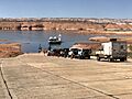
The Charles Hall Ferry pulling in to the Bullfrog terminus
|
|

Bullfrog Basin
Location in Utah
|
|
| Country | United States |
| State | Utah |
| County | Kane |
| Time zone | UTC-7 (Mountain (MST)) |
| • Summer (DST) | UTC-6 (MDT) |
| ZIP codes |
84533
|
| Area code(s) | 435 |
| GNIS feature ID | 1435217 |
|
Bullfrog Basin Airport
|
|||||||||||
|---|---|---|---|---|---|---|---|---|---|---|---|
| Summary | |||||||||||
| Airport type | Public | ||||||||||
| Owner | U.S. National Park Service | ||||||||||
| Serves | Glen Canyon National Recreation Area, Utah | ||||||||||
| Elevation AMSL | 4,167 ft / 1,270 m | ||||||||||
| Coordinates | 37°32′45″N 110°42′48″W / 37.54583°N 110.71333°W | ||||||||||
| Runway | |||||||||||
|
|||||||||||
| Statistics (2006) | |||||||||||
|
|||||||||||
|
Source: Federal Aviation Administration
|
|||||||||||
Bullfrog Basin is a fun recreation spot in Kane County, Utah, United States. It's part of the Glen Canyon National Recreation Area and sits right next to Lake Powell. This area is home to the Bullfrog Basin Airport, the Bullfrog Resort and Marina, the ferry that crosses the lake, and a campground. It's a great place for outdoor adventures!
Contents
What is Bullfrog Basin?
Bullfrog Basin is a popular area managed by the National Park Service. It offers many things for visitors to do. You can find the Defiance House Lodge here, which is a hotel built on a bluff overlooking Bullfrog Bay. The lodge is made of stucco and has several attached buildings.
Visitor Services and Facilities
At Bullfrog Basin, there's a visitor center where you can get information. The Bullfrog Resort and Marina has a restaurant, shops, and even a gas station for boats and cars. It's designed to make your visit easy and enjoyable.
How Bullfrog Basin Grew
The development of Bullfrog Basin was a big project in the 1960s. Calvin Rampton, who was the governor of Utah, strongly supported it. He helped get a special grant of $2.7 million in 1966. This money was used to build a paved road to the area.
Early Development Plans
Even before the road was finished, the National Park Service had already spent $1.5 million. They prepared the land for the airport, marina, and campground. They also planned to build a restaurant, a boat ramp, a motel, and a visitor center. The goal was to create a full-service recreation area.
Road Connections and Tourism
There were big plans for a road called the Lake Powell Parkway. This road would have connected Bullfrog to major highways, making it much easier for people to visit. It was part of a larger plan to link many national parks and attractions. However, this big road project faced challenges and was not built as planned. Instead, a cheaper idea to pave an existing dirt road was favored. This new road aimed to boost tourism in the area.
Life in Bullfrog Basin
By 1979, about 115 people lived in Bullfrog Basin year-round. This included park employees, workers at the resort, and state employees, along with their families. During the busy tourist season, the population could grow to about 200 people.
Housing and Community
Many residents lived in rented mobile homes. There were also some duplexes (buildings with two separate homes) for park and state employees. At one point, there was even a school in a mobile home with one teacher! This shows how Bullfrog Basin was a small, close-knit community.
Bullfrog Basin Airport
The Bullfrog Basin Airport is owned by the National Park Service. It's located about 5 miles north of Bullfrog Marina and Lake Powell. This airport is mainly used by visitors flying in to enjoy Lake Powell and the Glen Canyon National Recreation Area.
Airport Details
The airport covers about 42 acres. It has one runway that is 3,500 feet long and 40 feet wide. The runway surface is made of asphalt. In 2006, the airport had 451 aircraft operations. Most of these were general aviation flights, which are private or non-commercial flights.
Past Discussions About the Airport
In 1990, there was a discussion about possibly closing the Bullfrog Basin airport. This was because many flights were just going to a nearby airport, Cal Black Memorial, to refuel. Bullfrog Basin didn't have its own refueling facilities back then. Closing the airport was thought to reduce flights and noise. However, the airport remained open. In 1999, it had 6,690 total flights.
Climate
Bullfrog Basin has a desert climate. It gets very hot in the summer and can be quite cold in the winter.
| Climate data for Bullfrog Basin 1991-2020, extremes 1967- | |||||||||||||
|---|---|---|---|---|---|---|---|---|---|---|---|---|---|
| Month | Jan | Feb | Mar | Apr | May | Jun | Jul | Aug | Sep | Oct | Nov | Dec | Year |
| Record high °F (°C) | 67 (19) |
76 (24) |
85 (29) |
94 (34) |
102 (39) |
111 (44) |
114 (46) |
108 (42) |
106 (41) |
94 (34) |
81 (27) |
71 (22) |
114 (46) |
| Mean daily maximum °F (°C) | 46.3 (7.9) |
52.8 (11.6) |
63.3 (17.4) |
71.7 (22.1) |
81.8 (27.7) |
94.0 (34.4) |
99.6 (37.6) |
96.6 (35.9) |
87.9 (31.1) |
73.5 (23.1) |
58.3 (14.6) |
46.1 (7.8) |
72.7 (22.6) |
| Mean daily minimum °F (°C) | 26.0 (−3.3) |
29.6 (−1.3) |
36.4 (2.4) |
43.7 (6.5) |
53.4 (11.9) |
64.0 (17.8) |
71.4 (21.9) |
68.5 (20.3) |
59.5 (15.3) |
46.0 (7.8) |
34.0 (1.1) |
25.6 (−3.6) |
46.5 (8.1) |
| Record low °F (°C) | 3 (−16) |
4 (−16) |
15 (−9) |
21 (−6) |
33 (1) |
42 (6) |
54 (12) |
46 (8) |
43 (6) |
22 (−6) |
13 (−11) |
0 (−18) |
0 (−18) |
| Average precipitation inches (mm) | 0.63 (16) |
0.53 (13) |
0.65 (17) |
0.34 (8.6) |
0.44 (11) |
0.15 (3.8) |
0.59 (15) |
0.54 (14) |
0.81 (21) |
0.81 (21) |
0.53 (13) |
0.42 (11) |
6.44 (164.4) |
| Average snowfall inches (cm) | 0.9 (2.3) |
0.8 (2.0) |
0.3 (0.76) |
0 (0) |
0 (0) |
0 (0) |
0 (0) |
0 (0) |
0 (0) |
0 (0) |
0.2 (0.51) |
1.8 (4.6) |
4.0 (10) |
| Average precipitation days (≥ 0.01 in) | 4.2 | 4.0 | 4.1 | 3.0 | 2.7 | 1.3 | 3.0 | 4.0 | 3.9 | 3.6 | 2.6 | 3.7 | 40.1 |
| Average snowy days (≥ 0.1 in) | 0.5 | 0.6 | 0.2 | 0 | 0 | 0 | 0 | 0 | 0 | 0 | 0.1 | 1.1 | 2.5 |
| Source: NOAA | |||||||||||||
Images for kids
-
The Charles Hall Ferry pulling in to the Bullfrog terminus
