White Hills, Arizona facts for kids
Quick facts for kids
White Hills, Arizona
|
|
|---|---|

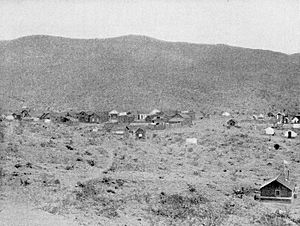
White Hills Mining Camp (1898)
|
|

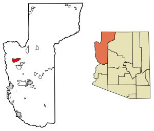
Location in Mohave County, Arizona
|
|
| Country | United States |
| State | Arizona |
| County | Mohave |
| Area | |
| • Total | 51.92 sq mi (134.48 km2) |
| • Land | 51.92 sq mi (134.48 km2) |
| • Water | 0.00 sq mi (0.00 km2) |
| Elevation | 2,792 ft (851 m) |
| Population
(2020)
|
|
| • Total | 345 |
| • Density | 6.64/sq mi (2.57/km2) |
| Time zone | UTC-7 (Mountain (MST)) |
| ZIP code |
86445
|
| Area code(s) | 928 |
| GNIS feature ID | 24687 |
| FIPS code | 04-82425 |
White Hills is a small community in Mohave County, Arizona, United States. It is an unincorporated community, meaning it does not have its own local government. It is also a census-designated place (CDP), which means the U.S. Census Bureau defines it for gathering statistics.
White Hills is about 12.5 miles (20.1 km) northwest of Dolan Springs. In 2020, the population of White Hills was 345 people.
Contents
History of White Hills
Silver Mining and Town Growth
In 1892, a man named Henry Shaffer found silver in the White Hills area. Local Native Americans helped him with this discovery. Because of the silver, many people came to the area to mine. This led to the creation of the town of White Hills.
The town grew quickly, and it is said that about 1,500 people lived there. The mines had a huge network of tunnels, stretching for about 27 miles (43 km). Within one mile (1.6 km) of the town, 15 different mines were actively digging for silver.
Mining Company and Decline
In 1894, the White Hills Mining Company was started to manage the mining work. However, they sold the company in 1895 for $1,500,000. The new owners were part of an English company. They built a large mill in the town to process the silver. This mill had 40 "stamps," which are heavy machines used to crush ore.
A big challenge was getting enough water. Water had to be piped in from 7 miles (11 km) away. Even with the pipes, there was never enough water for both the mines and the mill. Silver production was at its highest in 1898. Soon after, the mill could only operate half the time because of the water shortage. The town began to shrink and eventually became a ghost town.
Modern Developments: Wind Power
In 2020, a company called NextEra Energy started building a large wind farm near White Hills. This project had been planned for a long time. The wind farm will have 127 wind turbines. These turbines are expected to start producing electricity by the end of 2020.
The Southern California Clean Power Alliance has an agreement to buy 300 megawatts of power from this wind farm for 20 years. This shows how White Hills is now part of the effort to create clean energy. You can learn more about this at Wind power in Arizona.
Geography of White Hills
White Hills is located in the northwestern part of Mohave County. It sits in the Detrital Valley, which is a flat area. To the east of the community, the White Hills mountains rise up.
U.S. Route 93 is a major highway that runs through the western side of White Hills. If you travel southeast on Route 93, you will reach Kingman, which is about 42 miles (68 km) away. Kingman is the main city and county seat for Mohave County. If you go northwest on Route 93, you will reach Las Vegas, Nevada, which is about 64 miles (103 km) away.
Population Data
The population of White Hills has changed over the years. Here is a look at the population from recent U.S. Census counts:
| Historical population | |||
|---|---|---|---|
| Census | Pop. | %± | |
| 2010 | 323 | — | |
| 2020 | 345 | 6.8% | |
| U.S. Decennial Census | |||
See also
 In Spanish: White Hills (Arizona) para niños
 | Emma Amos |
 | Edward Mitchell Bannister |
 | Larry D. Alexander |
 | Ernie Barnes |


