Mount Trumbull, Arizona facts for kids
Quick facts for kids
Mount Trumbull, Arizona
|
|
|---|---|

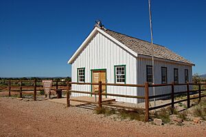
Mt. Trumbull School
|
|
| Country | United States |
| State | Arizona |
| County | Mohave |
| Elevation | 5,331 ft (1,625 m) |
| Time zone | UTC-7 (Mountain (MST)) |
| • Summer (DST) | UTC-7 (MST) |
| Area code(s) | 928 |
| FIPS code | 04-48100 |
| GNIS feature ID | 12738 |
Mount Trumbull is a small, populated place located in Mohave County, Arizona, in the United States. It has also been known by the name Bundyville. This area sits high up, about 5,331 feet (1,625 m) above sea level.
History of Mount Trumbull
One of the most important buildings in Mount Trumbull's past was the Mount Trumbull School. This old schoolhouse was built in 1922. It was a very busy place! It served as a school for kids, a church for services, a meeting room for the community, and even a dance hall for fun events.
The school was an important center for the people living nearby. It stayed open until 1966. Sadly, the first school building was later destroyed by a fire. But don't worry! An exact copy of the school was built again in 2001. Today, you can visit this rebuilt schoolhouse. It is now open to the public as an educational exhibit. In 1940, about 111 people lived in Mount Trumbull.
 | Audre Lorde |
 | John Berry Meachum |
 | Ferdinand Lee Barnett |


