Yucca, Arizona facts for kids
Quick facts for kids
Yucca, Arizona
|
|
|---|---|

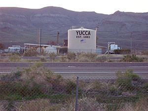
Water tank in Yucca, Arizona
|
|
 |
|
| State | Arizona |
| County | Mohave |
| Founded | 1883 |
| Area | |
| • Total | 2.24 sq mi (5.79 km2) |
| • Land | 2.24 sq mi (5.79 km2) |
| • Water | 0.00 sq mi (0.00 km2) |
| Population
(2020)
|
|
| • Total | 96 |
| • Density | 42.91/sq mi (16.57/km2) |
| Time zone | MST |
| ZIP code |
86438
|
| Area code(s) | 928 |
| FIPS code | 04-85470 |
Yucca is a small community in Mohave County, Arizona, United States. It is known as an unincorporated community, which means it doesn't have its own local government like a city or town. It is also a census-designated place (CDP), which is a special area the government uses for counting people.
In 2020, about 96 people lived in Yucca. This was a bit less than the 126 people who lived there in 2010. Yucca is located right next to Interstate 40, a major highway. It's southwest of Kingman. The community is surrounded by mountains, with the Black Mountains to the west and the Hualapai and McCracken Mountains to the east. Yucca has its own ZIP Code, 86438. Younger students in Yucca go to the local Yucca Elementary School District, while older students attend high school in the Kingman Unified School District.
Contents
Yucca's Past: A Look Back in Time
Yucca began in the 1880s. It was a stop for the Atlantic and Pacific Railroad. Trains would stop there to get orders and fill up their water tanks. This railroad line was very important. It was built to connect St. Louis, Missouri, all the way to Needles, California. Over time, this railway became a major route for moving goods across the country, especially to Southern California. Yucca even started its own cemetery in 1918.
Yucca's Role in World War II
During World War II, the United States Army Air Forces bought a large area of land near Yucca. They turned it into the Yucca Army Airfield. This airfield was used to train pilots for the war.
After the war, in 1954, the Ford Motor Company bought the old air base. They added more land to it and created the Arizona Proving Ground. This was a huge area where Ford tested its cars. Later, in 2007, another car company, Chrysler, bought these proving grounds from Ford.
The Route 66 Era
In 1952, Yucca became part of the famous U.S. Route 66. The highway was changed to go through Yucca, bypassing another town called Oatman, Arizona. This was a great time for Yucca! The small town had motels, cafés, and a Whiting Brothers truck stop. Many travelers stopped there.
However, in the early 1970s, Interstate 40 was built. It replaced the section of Route 66 that went through Yucca. This meant fewer people stopped in Yucca. The motels and truck stop eventually closed down. Travelers started using the bigger facilities in nearby Kingman and Needles. By 2008, only a few businesses remained, like a small general store, a post office, and an auto repair shop.
New Beginnings for Yucca
In 1997, a big land deal happened near Yucca. The Santa Fe Railroad and the U.S. Government exchanged about 70,000 acres of land. Much of the land the railroad received was then divided into smaller pieces, usually 40 acres each. These pieces were sold to people as part of a development called Stage Coach Trails. Most people bought this land to build homes or as an investment for the future. Other smaller housing areas also started north of Yucca in 2006. These new homes might help bring more businesses back to the area over time.
Yucca's Location and Weather
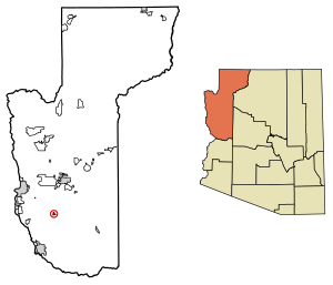
Yucca is located in the southern part of Mohave County. It's about 35 miles north of Lake Havasu City. It's also about 24 miles southwest of Kingman, which is the main city in the county. Needles, California, is about 38 miles to the east.
Yucca has a hot desert climate. This means it has very hot summers and cool winters. In summer, it's common for temperatures to be above 110 degrees Fahrenheit (43 degrees Celsius) for many days in a row. Winters are usually mild, and it almost never snows. The most rain Yucca gets in a month is usually around 4 inches (10 cm). In winter, the lowest temperatures are usually between 30 and 45 degrees Fahrenheit (-1 to 7 degrees Celsius). Most of the limited rain falls during the cooler months.
| Climate data for Yucca, Arizona (1991–2020 normals, extremes 1953–2007, 2009–2017) | |||||||||||||
|---|---|---|---|---|---|---|---|---|---|---|---|---|---|
| Month | Jan | Feb | Mar | Apr | May | Jun | Jul | Aug | Sep | Oct | Nov | Dec | Year |
| Record high °F (°C) | 84 (29) |
87 (31) |
97 (36) |
103 (39) |
112 (44) |
117 (47) |
120 (49) |
119 (48) |
111 (44) |
105 (41) |
89 (32) |
81 (27) |
120 (49) |
| Mean daily maximum °F (°C) | 61.1 (16.2) |
64.7 (18.2) |
71.5 (21.9) |
79.1 (26.2) |
88.5 (31.4) |
99.2 (37.3) |
103.2 (39.6) |
102.3 (39.1) |
96.4 (35.8) |
83.9 (28.8) |
70.5 (21.4) |
60.0 (15.6) |
81.7 (27.6) |
| Daily mean °F (°C) | 49.5 (9.7) |
52.4 (11.3) |
58.3 (14.6) |
64.7 (18.2) |
74.1 (23.4) |
84.0 (28.9) |
90.3 (32.4) |
89.3 (31.8) |
82.0 (27.8) |
69.7 (20.9) |
57.4 (14.1) |
48.4 (9.1) |
68.3 (20.2) |
| Mean daily minimum °F (°C) | 37.9 (3.3) |
40.0 (4.4) |
45.2 (7.3) |
50.4 (10.2) |
59.7 (15.4) |
68.9 (20.5) |
77.4 (25.2) |
76.3 (24.6) |
67.7 (19.8) |
55.5 (13.1) |
44.2 (6.8) |
36.9 (2.7) |
55.0 (12.8) |
| Record low °F (°C) | 11 (−12) |
18 (−8) |
21 (−6) |
31 (−1) |
35 (2) |
46 (8) |
48 (9) |
48 (9) |
40 (4) |
28 (−2) |
23 (−5) |
15 (−9) |
11 (−12) |
| Average precipitation inches (mm) | 1.06 (27) |
1.29 (33) |
0.83 (21) |
0.27 (6.9) |
0.10 (2.5) |
0.05 (1.3) |
0.45 (11) |
0.55 (14) |
0.49 (12) |
0.52 (13) |
0.46 (12) |
0.59 (15) |
6.66 (169) |
| Average snowfall inches (cm) | 0.0 (0.0) |
0.0 (0.0) |
0.0 (0.0) |
0.0 (0.0) |
0.0 (0.0) |
0.0 (0.0) |
0.0 (0.0) |
0.0 (0.0) |
0.0 (0.0) |
0.0 (0.0) |
0.0 (0.0) |
0.0 (0.0) |
0.0 (0.0) |
| Average precipitation days (≥ 0.01 in) | 3.3 | 4.3 | 3.3 | 1.5 | 0.9 | 0.2 | 2.4 | 3.2 | 2.2 | 2.0 | 1.9 | 3.1 | 28.3 |
| Average snowy days (≥ 0.1 in) | 0.0 | 0.0 | 0.0 | 0.0 | 0.0 | 0.0 | 0.0 | 0.0 | 0.0 | 0.0 | 0.0 | 0.0 | 0.0 |
| Source: NOAA | |||||||||||||
Population of Yucca
| Historical population | |||
|---|---|---|---|
| Census | Pop. | %± | |
| 2010 | 126 | — | |
| 2020 | 96 | −23.8% | |
| U.S. Decennial Census | |||
See also
 In Spanish: Yucca (Arizona) para niños
 | Janet Taylor Pickett |
 | Synthia Saint James |
 | Howardena Pindell |
 | Faith Ringgold |


