
Hualapai Mountains facts for kids
Quick facts for kids Hualapai Mountains |
|
|---|---|

The Hualapai Mountains seen from Kingman in late December with a light dusting of snow.
|
|
| Highest point | |
| Peak | Hualapai Peak |
| Elevation | 8,417 ft (2,566 m) |
| Naming | |
| Native name | Error {{native name}}: an IETF language tag as parameter {{{1}}} is required (help) |
| Geography | |

Location in Arizona
|
|
| Country | United States |
| State | Arizona |
| County | Mohave County |
| Range coordinates | 34°54′00″N 113°53′03″W / 34.900008°N 113.8841121°W |
| Topo map | USGS Hualapai Peak, Dean Peak |
The Hualapai Mountains are a cool mountain range in Mohave County, Arizona. They are close to the city of Kingman. The name "Hualapai" means "People of the tall Pines" in the Hualapai language. This name comes from the Native American tribe who lived here.
These mountains have five main peaks. They are Dean Peak, Getz Peak, Aspen Peak, and Hayden Peak. These peaks look out over the wide Hualapai Valley towards Kingman. The tallest peak is Hualapai Peak, located on the south side. You can find hiking trails that lead to Aspen and Hayden Peaks. Some peaks, like Getz and Hayden, have radio towers on them.
Contents
Nature and Wildlife in Hualapai Mountains
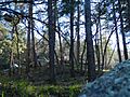
The Hualapai Mountains are covered in many pine trees. You will mostly see pinyon pine trees here. If you go higher than 5,500 feet (1,700 m), you will start to see ponderosa pine trees. Most of these pine trees grow on the cooler slopes that face north. This area is mainly a forest and has many natural springs.
The nature here is similar to other mountain areas in southern California. It has large forests with many types of conifer trees. You can also find aspen groves in the higher parts. The higher areas of the Hualapai Mountains are like special "sky islands" for plants and animals.
Animals of Hualapai Mountains
Many animals live in the Hualapai Mountains. You might see bears, elk, mule deer, and mountain lions. There are also javelinas and other animals. Mountain lions and bears sometimes come closer to towns because there are many deer for them to hunt.
Some animals are special because they only live in the Hualapai Mountain range. These include a type of ground squirrel and a kind of tarantula.

Hualapai Mountain County Park

Hualapai Mountain Park is a county park. It was first built in the 1930s by a group called the Civilian Conservation Corps. The park covers more than 2,300 acres (9.3 km2) of land. The elevation in the park ranges from 4,984 feet (1,519 m) to 8417 feet.
The park offers different places to stay. You can rent cabins, or use areas for camping. There are also spots for recreational vehicles and even teepees that you can rent.
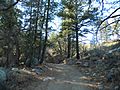
There are 10 miles (16 km) of hiking trails in the park. They have different difficulty levels, so there's a trail for everyone. There's also a special trail head for ATVs. This park has a special route to help people leave safely during wildfires.
The Mohave County Parks department manages the park. You can find small signs around the park. These signs tell you about the park's history, the plants you see, and other interesting things.
Many homes are located in the mountains and foothills. These communities are not official towns. They are managed by Mohave County. The Pinion Pine community has two fire stations. One of these stations has full-time staff.
Pine Lake Community
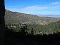
At the top of the Hualapai Mountain, just past the Hualapai Mountain Park, is a community called Pine Lake. About 140 homes are in this community. It is a little over 6,000 ft (1,800 m) high. The Hualapai Mountain Resort is one of the places you can visit in Pine Lake.
The Pine Lake community has a volunteer fire department. This group also holds fun events for the neighborhood throughout the year. There is a lodge and cabins you can rent. Some people also live there all the time. The lake itself is privately owned. It belongs to the Pine Lake Inn Bed and Breakfast, so it is not open to the public.
Elk often visit Pine Lake. You will also see many mule deer walking around every day.
Off-Road Adventures
From the Pine Lake Community, you can find many dirt roads that go out into the mountains. There are two main ways to get out of the community. One is Flag Mine Road. The other is the ATV trail head at Hualapai Mountain Park. This helps spread out the traffic in the neighborhood.
Flag Mine Road lets you reach many different paths. These paths go along the mountain ridges and through valleys and canyons. If you keep going on Flag Mine Road, you will be over 7,000 ft (2,100 m) high. Many routes branch off this road, including the Moss Wash Basin. At the end of Flag Mine Road, you will find the Boreana Mine. This road also leads to Yucca. There is a private campground on Flag Mine Road.
Images for kids
-
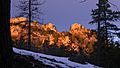
Aspen Peak, as seen from Pine Lake
-
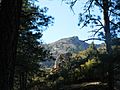
Diverse plant communities in Hualapai Mountains
-
Xeric plant communities in Hualapai Mountains
-
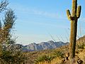
Desert plant communities in the Hualapai Mountain foothills
-
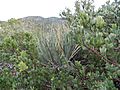
Mixed scrub, yucca, and cacti in Hualapai Mountain Foothills
-
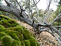
Delicate ecosystems emerge from dying scrub
-
(left) Pinyon Pine, (right) Juniper, (bottom left) Yucca, (bottom middle) Manzanita
-
Lush micro-climates exist in the upper reaches of the Hualapai Mountains
-
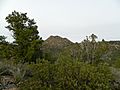
A unique world about the Mohave Desert
-
Overlook of Pine Lake Community
-
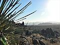
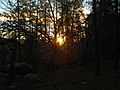
A snippet of the Arizona Peace Trail in the Hualapai Mountains
-
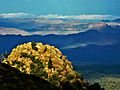
An exceptional view of the Aquarius Mountains from the top of the AZ Peace Trail


.jpg)
