
Black Mountains (Arizona) facts for kids
The Black Mountains are a long mountain range in northwest Arizona. They stretch about 75 miles (121 km) (120 km) from north to south. This mountain range forms the western border of Mohave County. It runs along the eastern side of the Colorado River, starting near Hoover Dam.
Parts of the Black Mountains are inside the beautiful Lake Mead National Recreation Area. There are also three special wilderness areas within the mountains. The old mining town of Oatman is found in the southern part of the range. It's located between the Mount Nutt and Warm Springs wilderness areas, about 4 miles north of Boundary Cone.
Quick facts for kids Black Mountains |
|
|---|---|

Black Mountains, N-to-S
view from Needles, California east-northeast (overlooking Mohave Valley and Colorado River) (large block at right-(south)-Black Mesa (Black Mountains) |
|
| Highest point | |
| Peak | Mount Perkins |
| Elevation | 5,456 ft (1,663 m) |
| Dimensions | |
| Length | 75 mi (121 km) N-S |
| Width | 13 mi (21 km) (variable) |
| Geography | |

Black Mountains
Location in Arizona
|
|
| Country | United States |
| State | Arizona |
| Region | Mojave Desert Boundary Cone |
| District | Mohave County, Arizona |
| Settlement | Oatman, Arizona-(south)–Kingman, Arizona Needles, California |
| Borders on | Lake Mead-NW Colorado River-W Detrital Valley-NE White Hills–Hualapai Valley-NE Cerbat Mountains-E Sacramento Valley & Hualapai Mtns-SE Interstate 40 in Arizona-SE & S |
| Rivers | Colorado River, Detrital and Sacramento Washes |
What are the Black Mountains like?
The Black Mountains are usually about 10 to 15 miles (16-24 km) wide. They are narrower in the northern parts. The southern part of the range is wider and includes the two wilderness areas. One section, called Black Mesa, is part of the Warm Springs Wilderness. It is separated from the northern part of the mountains by Sitgreaves Pass, which is on the road to Oatman.
The highest point in the range is Mount Perkins. It stands at 5,456 feet (1,663 m) (1,663 meters) tall. Mount Perkins is located in the north-central part of the range.
Where does the water go?
The Black Mountains are part of four different watersheds. A watershed is an area of land where all the water drains into a single river, lake, or ocean.
- The northern and northeastern parts of the mountains drain into the Lake Mead Watershed.
- The Detrital Wash Watershed also flows north from the mountains.
- The western side, along the Colorado River, and the southwestern part are in the Havasu-Mohave Lakes Watershed.
- The Sacramento Wash Watershed flows into the southern part of the Topock Marsh. This marsh is located in the Havasu-Mohave Lakes region.
Images for kids
-
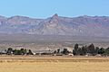
Boundary Cone, a prominent landmark in the western foothills of the Black Mountains, viewed from Mohave Valley
-
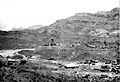
Historic Oatman, AZ, 1921


