
Sacramento Wash facts for kids
Quick facts for kids Sacramento Wash |
|
|---|---|

Topock Marsh
Outfall region of the Sacramento Wash |
|
| Lua error in Module:Location_map at line 420: attempt to index field 'wikibase' (a nil value).
Sacramento Wash in the Sacramento Valley of Arizona
|
|
| Country | United States |
| State | Arizona |
| Region | (southeast)-Mojave Desert |
| District | Mohave County, Arizona |
| City | Yucca, Arizona Golden Valley, Arizona-(north) |
| Physical characteristics | |
| Length | 50 mi (80 km), N-S, then W-(for 20 mi)) |
The Sacramento Wash is a major natural waterway in northwest Arizona. It's located in Mohave County. This wash flows into the Colorado River, about 45 miles south of Lake Mohave. It's also about 90 miles south of Hoover Dam at Lake Mead.
The Sacramento Wash is a type of desert stream called an ephemeral wash. This means it usually only has water after heavy rains. Sometimes, water can be found in small streams in the mountains that feed into it. Most of the water from the wash soaks into the ground, becoming part of the groundwater. One of its small streams, Sawmill Canyon, sometimes has water flowing in it.
The wash flows through the Sacramento Valley. To the west of the valley are the Black Mountains (Arizona). A major highway, Interstate 40 in Arizona, travels south from Kingman. It then goes west around the southern part of the Black Mountains, an area known as the Black Mesa. I-40 meets the Sacramento Wash near Yucca, Arizona and follows it west to the Colorado River at Needles.
What is Topock Marsh?
The Sacramento Wash meets the Colorado River at a special place called the Topock Marsh. This marsh is a wetland area located to the east of the main Colorado River. It has two parts that are connected.
Topock Marsh is a very important place for nature. Many people enjoy visiting it for birdwatching because of all the different birds that live there. The part of the river that includes the marsh is about 25 miles long and is protected as part of the Havasu National Wildlife Refuge.
How Does Water Flow in Northwest Arizona?
All the water in northwest Arizona eventually flows into the Colorado River or the southeastern part of Lake Mead. The area where the Sacramento Wash collects its water is called the Sacramento Wash Watershed.
To the southeast and south, the Sacramento Wash Watershed is next to the Bill Williams River. The Bill Williams River also flows west into the Colorado River, just like the Sacramento Wash. The Big Sandy River is a northern branch of the Bill Williams River. It drains the areas east of the Sacramento Valley.
The Bill Williams River also acts as a natural border. To its north and northwest is the Mojave Desert. To its south and southeast is the Sonoran Desert. The Colorado Desert is to the southwest and is considered an extension of the Sonoran Desert.
 |
Lake Mead | (Lake Mead Watershed) Detrital Wash Watershed [1] |
Hualapai Wash Watershed (endorheic south half) [2] | |
| Colorado River Havasu-Mohave Lakes Watershed [3] |
Big Sandy Watershed [4] | |||
| Colorado River Bill Williams Watershed [5] |
Bill Williams Watershed | B. S. & B. W. Watersheds (Alamo Lake) |
Images for kids
-
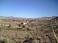
north section of Sacramento Valley, with townsite of Golden Valley
-
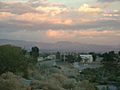
Northwest flatland region, Golden Valley area, north source area of Sacramento Wash
-
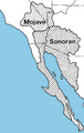
Mojave and Sonoran Deserts


