
Mohave Valley facts for kids
Quick facts for kids Mohave Valley |
|
|---|---|

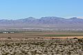
Mohave Valley, looking east from California
with Black_Mountains of AZ in the distance |
|

Mohave Valley
Location in Arizona
|
|
| Length | 25 mi (40 km) |
| Width | 10 mi (16 km) |
| Geography | |
| Location | Arizona/Nevada/California Lower Colorado River Valley (southeast)-Mojave Desert ((northwest)-Sonoran Desert) |
| Borders on | Colorado River-W Black Mesa (western Arizona)-E Black Mountains (Arizona)-NE Mohave Mountains-S Newberry Mountains (Nevada)-NW Dead Mountains-W & NW Sacramento Mountains (California)-SW |
The Mohave Valley is a large valley located mostly in northwest Arizona. It sits along the eastern side of the Colorado River, which flows south. This valley also stretches into California and Nevada.
The main part of the valley is in southwest Mohave County, Arizona. It's where two big deserts meet: the southeast Mojave Desert and the northwest Sonoran Desert.
The valley reaches into three different states: Arizona, California, and Nevada. The Fort Mojave Indian Reservation also covers parts of these three states. To the west, the valley touches the Dead Mountains in California. These mountains look over the spot where the three states meet.
The city of Needles is on the southwest edge of the valley. It's located along Interstate 40. From Needles, you can see the Havasu National Wildlife Refuge and the Topock Marsh. The small village of Topock is at the southern end of the valley. Here, the Chemehuevi Mountains in California make the Colorado River flow through a narrow area called Mohave Canyon.
Contents
Exploring Mohave Valley
Mohave Valley is about 25 miles (40 km) long, running from north to south. It can be up to 10 miles (16 km) wide in some places. The town of Mohave Valley, Arizona is right in the middle of the valley. It's also in the center of the Fort Mojave Indian Reservation.
Bullhead City is at the northern edge of the valley. Needles is on the valley's southwest border in California. Further south, near the valley's end, is the Topock Marsh in Arizona.
Also at the southern end, Interstate 40 in Arizona climbs uphill out of the Sacramento Wash. This highway then enters the Sacramento Valley. This larger valley is mostly to the east and southeast of the Black Mountains.
The town center of Mohave Valley, Arizona, is located at 34°57′25″N 114°35′5″W / 34.95694°N 114.58472°W. This spot is near the valley's center, slightly west towards the Colorado River. An important landmark called Boundary Cone is to the east. It sits near the Black Mesa, which is part of the southern Black Mountains.
Water Flow in the Valley
Water from Arizona's East and Southeast
The southern part of Mohave Valley has higher ground. The Mohave Mountains are directly to the south. East of these mountains is Dutch Flat, which drains water northwest into the Sacramento Wash.
The southeast part of Mohave Valley meets the end of the Sacramento Wash. This wash carries water from the Sacramento Valley. The Sacramento Valley is mostly east and south of the Black Mesa. The Sacramento Wash then turns west and follows Interstate 40 in Arizona. It flows into Needles at the Colorado River. This is also where water drains into the Topock Marsh. Other washes also bring water from the southwest of the Black Mountains into the Topock Marsh.
Water from Nevada's Northwest
Just like the Sacramento Wash brings water from Arizona, the Piute Wash drains the Piute Valley in southeast Nevada. There's also a separate area called the Havasu-Mohave Lakes Drainage along the Colorado River. All three of these areas—from the west, center, and east—send their water into the Mohave Valley region.
Images for kids
-
Mohave Valley looking north, with Boundary Cone on the right.
-
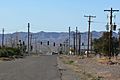
A view of Mohave Valley, Arizona.
-
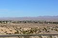
Looking east-northeast from Needles, showing Mohave Valley and the Black Mountains (Arizona).


