
Mohave Mountains facts for kids
Quick facts for kids Mohave Mountains |
|
|---|---|

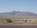
View looking southwest from Lake Havasu City area — south portion of Mohave Mountains
|
|
| Highest point | |
| Peak | Crossman Peak (center-south (see text)) |
| Elevation | 5,103 ft (1,555 m) |
| Dimensions | |
| Length | 18 mi (29 km) NW-SE |
| Width | 6 mi (9.7 km) |
| Geography | |

Location in Arizona
|
|
| Country | United States |
| Communities | Lake Havasu City, Franconia and Lake Havasu Heights |
| Range coordinates | 34°35′N 114°14′W / 34.583°N 114.233°W |
The Mohave Mountains are a small mountain range in northwest Arizona. They stretch about 18 miles (29 km) long. These mountains are in southwest Mohave County. They run alongside a part of the Colorado River that flows southeast. This river forms the border between Arizona and California.
The Mohave Mountains also create the southwest edge of a flat area. This area is called Dutch Flat. It is located to the east and north of the mountains. Lake Havasu City, Arizona, is on the Colorado River. It sits across from the southwest side of the Mohave Mountains. This is where the famous London Bridge was rebuilt at Lake Havasu.
Interstate 40 is a major highway. It goes east from Needles, California, near the north of the mountains. It then turns north through the Sacramento Valley towards Kingman, Arizona. The very end of the Mohave Mountains in the northwest turns into rocky hills. This area is on the east side of the Colorado River and is known as The Needles.
Exploring the Mohave Mountains
The Mohave Mountains mostly run from northwest to southeast. They have a slight curve towards the east at their southern end. This curve leads into the southwest part of Dutch Flat. The northern part of the range has lower hills. These hills border the area known as The Needles.
The middle and southern parts of the mountains have a large, high area. This area includes the highest point of the range, Crossman Peak. Crossman Peak stands tall at 5,103 feet (1,555 meters). Lake Havasu City is much lower, at 602 feet (183 meters) above sea level. This means the Mohave Mountains rise about 4,000 to 4,500 feet above the surrounding land.
How to Visit the Mohave Mountains
You can reach the Mohave Mountains from Arizona State Route 95. This road runs along the east bank of the Colorado River. There are also dirt roads from Arizona 95 that lead into the northwest and north parts of the range. Lake Havasu Heights is located in this northern area.
Another dirt road, called Dutch Flat Road, starts from Arizona 95. It goes northeast along the southeast side of the mountains. This road reaches Dutch Flat. From there, you can find other dirt roads to explore the entire eastern side of the range.
A dirt path from Franconia Wash also leads to the northeast side of Crossman Peak. Franconia Wash is in northwest Dutch Flat, near Franconia on I-40. Another dirt road begins at the end of Bison Blvd in Lake Havasu City. It follows Falls Springs Wash to a gate. Beyond the gate, a very steep path goes up to a radio antenna complex. This complex is near the top of Crossman Peak. Hikers can use the gated part of this path. From the ridgeline, you can see great views of Dutch Flat and the Lake Havasu valley.
You can also get to the dirt roads in Dutch Flat and the northern parts of the mountains from Interstate 40. I-40 is about 7 miles (11 km) north of the mountains' northern end.
Images for kids
-
Crossman Peak, seen from Arizona 95
-
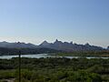
The Needles, at Topock Gorge
(view ~southeast on the Colorado)


