Sacramento Mountains (California) facts for kids
Quick facts for kids Sacramento Mountains |
|
|---|---|

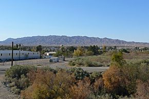
view looking south from River Bridge
(6-(?) miles north of Needles) |
|
| Highest point | |
| Peak | Eagle Peak |
| Elevation | 3,308 ft (1,008 m) |
| Dimensions | |
| Length | 16 mi (26 km) NW-SE |
| Width | 10 mi (16 km) |
| Geography | |
| Country | United States |
| Settlements | Needles, California and Topock, Arizona |
| Range coordinates | 34°46′30″N 114°45′3″W / 34.77500°N 114.75083°W |
| Topo map | USGS Flattop Mountain |
The Sacramento Mountains are a cool mountain range located in the eastern part of the Mojave Desert. You can find them in San Bernardino County, California. These mountains are also part of the amazing Mojave Trails National Monument.
Contents
Where Are the Sacramento Mountains?
These mountains are found southwest of a town called Needles. They form part of the town's western and southwestern edge. To the east, you'll find the Piute Mountains. The Dead Mountains are to the north, and the Chemehuevi Mountains are to the southeast.
The Sacramento Mountains stretch from the northwest to the southeast. They are located south of Interstate 40. The highest point in the range is Eagle Peak, which stands at 3,308 feet (about 1,008 meters) above sea level. The entire mountain range is about 16 miles (26 kilometers) long.
Important Spots in the Mountains
- Eagle Pass and Eagle Peak are in the south-central part of the range.
- An unpaved road goes through Eagle Pass. This road connects Needles to the Ward Valley.
- Flattop Mountain is another peak in the range. It is 3,029 feet (923 meters) tall. You can find it in the northwest part of the mountains, just south of Interstate 40.
Rivers and Valleys Nearby
The Sacramento Mountains have several important natural borders:
- To the west, they are bordered by the Ward Valley. This valley connects to the Chemehuevi Valley and Wash further southeast.
- The southeastern part of the Sacramento Mountains connects to the Chemehuevi Mountains. These two ranges are similar in size.
- To the east, both ranges are bordered by the Colorado River. This river flows southeast before turning southwest near the Whipple Mountains.
The town of Needles is located to the east and southeast of the mountains. The Colorado River flows along the edge of the mountains near Needles. This river also passes by the southwest corner of the Mohave Valley and the Fort Mojave Indian Reservation.
Near the southern part of the Mohave Valley, Interstate 40 in California crosses into Arizona. This crossing happens south of Topock and the Topock Marsh.
The Chemehuevi Wash and Valley are southwest of the Sacramento Mountains. This is one of the main washes (dry riverbeds) on the California side of the Colorado River. The Piute Wash drains northwest of Needles.
Why the Name "Sacramento"?
The Sacramento Mountains get their name from the Sacramento Wash and Sacramento Valley. These are located across the Colorado River in Arizona. The Sacramento Wash drains the northwestern part of Mohave County, Arizona into the Topock Marsh.
Neighboring Mountain Ranges
The Sacramento Mountains are surrounded by other mountain ranges:
- Turtle Mountains are to the south.
- Piute Mountains are to the west.
- Dead Mountains are to the north.
- Chemehuevi Mountains are to the southeast.
 | William L. Dawson |
 | W. E. B. Du Bois |
 | Harry Belafonte |


