Whipple Mountains facts for kids
Quick facts for kids Whipple Mountains |
|
|---|---|
| Highest point | |
| Peak | Whipple Peak |
| Elevation | 4,131 ft (1,259 m) |
| Dimensions | |
| Length | 20 mi (32 km) N-S |
| Width | 25 mi (40 km) E-W |
| Geography | |
| Country | United States |
| State | California |
| Region | Colorado Desert ((northwest)-Sonoran Desert) |
| District | San Bernardino County |
| Range coordinates | 34°17′53″N 114°26′18″W / 34.29806°N 114.43833°W |
| Borders on | Colorado River-NE & SE California State Route 62-S |
| Topo map | USGS Whipple Mountains SW |
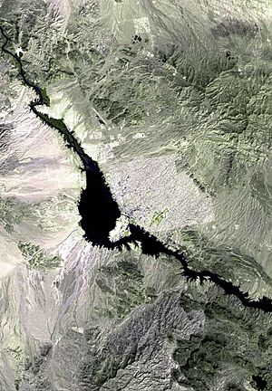
The Whipple Mountains are a cool mountain range in eastern San Bernardino County, California. They are right next to the Colorado River, Parker Dam, and Lake Havasu. You can find them south of Needles, California and north of Parker, Arizona.
These mountains make the Colorado River change its path. The river flows north-south, then turns southeast, and then southwest around the mountains. The highest point is Whipple Mountain, which is about 4,131 feet (1,259 meters) tall.
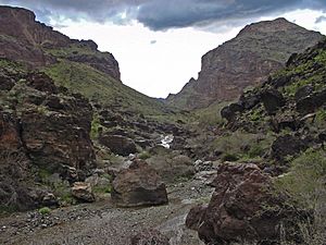
The western part of the mountains looks pale green. But the eastern side has striking brick-red rocks formed by volcanoes. You can see many different landforms here. These include wide valleys, dry riverbeds called washes, deep canyons, and tall, eroded rock spires.
The mountains got their name from Amiel Weeks Whipple. He was a US Army lieutenant who explored the area in the 1840s.
Contents
Exploring the Whipple Mountains: Location and Features
The Whipple Mountains stretch for about 25 miles (40 kilometers) from east to west. Their highest point is Whipple Peak, which reaches 4,131 feet (1,259 meters). This peak is located west of the center of the range.
The mountains are part of the Colorado Desert. This desert is the northwestern part of the larger Sonoran Desert. They are also in the Lower Colorado River Valley region.
- To the west, you'll find the Turtle Mountains.
- The Mopah Range is right next to them on the south.
- The Chemehuevi Mountains are upriver to the north.
Many mines used to operate in the Whipple Mountains. These include the Independence Mine and Bessie Mine.
Climate in the Whipple Mountains
The Whipple Mountains have a very dry climate. They get less than 6 inches (150 millimeters) of rain each year. Summers are extremely hot, often reaching over 104°F (40°C). Winters, however, are usually mild and pleasant.
How the Whipple Mountains Formed: Geology
Today, the Whipple Mountains look like several parallel ridges. These ridges run from northwest to southeast. A large dry riverbed, called Whipple Wash, cuts across the entire range.
These ridges are actually the tops of tilted blocks of Earth's crust. They sit above a huge crack in the Earth called a detachment fault. The Whipple Mountains are one of the best places in the world to study these types of faults. They are known as a metamorphic core complex. This means deep rocks were brought closer to the surface by the fault.
In the western part of the mountains, the upper layers of rock have worn away. This shows older, deeper rocks that were changed by heat and pressure. In the east, you can still see younger volcanic rocks. But the washes (dry riverbeds) let you see the main fault line and the rocks around it.
The Whipple detachment fault is part of a bigger system of faults. These faults helped the Earth's crust stretch out a lot. This happened between the Sierra Nevada mountains and the Colorado Plateau millions of years ago. The area stretched by more than 25 miles (40 kilometers)!
History of the Whipple Mountains
For thousands of years, different Native American groups lived in and traveled through the Whipple Mountains. These included the Mojave, Cahuilla, and Quechan tribes.
In the 1770s, an explorer and missionary named Francisco Garcés explored this region. In 1774, he joined the famous Juan Bautista de Anza expedition. They traveled through the Whipple Mountains on their way to Alta California. They traveled peacefully with the local Native American people.
Later, in the early 1900s, the famous Old West figure Wyatt Earp spent his last winters here. He worked on small gold and copper mines starting around 1906. The nearby town of Earp, California was named after him. However, he actually lived in the town of Vidal, California.
Today, some parts of the Whipple Mountains are owned by the State of California or by private individuals. The Bureau of Land Management (BLM) manages other parts.
Whipple Mountains Wilderness Area
Most of the Whipple Mountains are part of the Whipple Mountains Wilderness. This wilderness area is managed by the Needles Field office of the Bureau of Land Management. It covers about 76,122 acres (30,805 hectares) of the mountain range. This area is protected to keep its natural beauty and wildlife safe.
See also
 In Spanish: Montañas Whipple para niños
 | Shirley Ann Jackson |
 | Garett Morgan |
 | J. Ernest Wilkins Jr. |
 | Elijah McCoy |


