
Parker, Arizona facts for kids
Quick facts for kids
Parker, Arizona
|
||
|---|---|---|
_Parker_Downtown.jpg)
Historic Downtown Parker
|
||
|
||

Location of Parker in La Paz County, Arizona
|
||

Parker, Arizona
Location in the United States
|
||
| Country | United States | |
| State | Arizona | |
| County | La Paz | |
| Named for | Ely S. Parker | |
| Area | ||
| • Total | 21.99 sq mi (56.95 km2) | |
| • Land | 21.98 sq mi (56.92 km2) | |
| • Water | 0.01 sq mi (0.03 km2) | |
| Elevation | 764 ft (233 m) | |
| Population | ||
| • Total | 3,417 | |
| • Density | 155.46/sq mi (60.03/km2) | |
| Time zone | UTC-7 (MST (no DST)) | |
| ZIP code |
85344
|
|
| Area code(s) | 928 | |
| FIPS code | 04-53070 | |
| GNIS feature ID | 2413116 | |
| Website | Town Website | |

Parker is a town in Arizona, United States. It is the main town, or county seat, of La Paz County. Parker is located right by the Colorado River in a place called Parker Valley. The Mojave people call it Amat Kuhwely, and it was once known as Ahwe Nyava. In 2020, about 3,417 people lived in Parker.
Contents
History of Parker, Arizona
Parker was started in 1908. It was named after Ely Parker, who was a very important Native American leader. He was the first Native American to be a commissioner for the U.S. government.
How Parker Was Founded
The town's first layout was planned in 1909 by Earl H. Parker. He was an engineer for the Arizona & California Railway. The town officially became a city in 1948. Later, on January 1, 1983, it became the county seat for the new La Paz County.
Early Days: Camp Colorado and Parker's Landing


The name "Parker" comes from a post office set up on January 6, 1871. This post office was at a place called Parker's Landing. This spot was important because it was where supplies were brought for the Indian Agency. The Indian Agency was named after Ely Parker.
Parker's Landing was also where the U. S. Army had a camp called Camp Colorado. Soldiers were stationed there from 1864 to 1869. The camp was closed after a steamboat called Cocopah accidentally caused a fire. The fire burned down some of the officers' huts.
Geography of Parker, Arizona
Parker is located on the Colorado River. It is just south of the Headgate Rock Dam and Moovalya Lake. Two main roads serve the town: Arizona State Route 95 and California State Route 62. Route 62 is across the Colorado River in California.
Land and Water Area
The United States Census Bureau says Parker covers about 22 square miles (57 square kilometers). Almost all of this area is land. Only a tiny part, about 0.05%, is water.
Sections of Parker
Parker is split into two parts that are not connected. The northern part is the original town. It is located within the Colorado River Indian Reservation. The southern part is much larger and mostly undeveloped. This southern area has many unpaved roads. One of the few paved roads, Mohave Road, is used a lot. You can take Mohave Road south for about 15.5 miles to reach the town of Poston. Poston is known for its camps where Japanese Americans were moved during World War II.
Climate in Parker, Arizona
Parker has a very dry climate, also known as an arid climate. This means it has extremely hot summers and warm winters.
Winter Weather in Parker
In winter, daytime temperatures in Parker are usually around 60 to 70 degrees Fahrenheit (15 to 21 degrees Celsius). Nighttime lows are between 40 and 50 degrees Fahrenheit (4 to 10 degrees Celsius). Sometimes, the temperature can drop below 32 degrees Fahrenheit (0 degrees Celsius). The coldest temperature ever recorded in Parker was 9 degrees Fahrenheit (minus 13 degrees Celsius) on December 31, 1911. Snow has only fallen once, in December 1932, when 3 inches (7.6 cm) fell.
Summer Weather in Parker
Summers in Parker are very hot and can be dangerous. From June to September, temperatures often stay between 100 and 110 degrees Fahrenheit (38 to 43 degrees Celsius). Days over 115 degrees Fahrenheit (46 degrees Celsius) or even 120 degrees Fahrenheit (49 degrees Celsius) are common.
April and May usually have daytime highs between 90 and 100 degrees Fahrenheit (32 to 38 degrees Celsius). Even in October, the average high is 90 degrees Fahrenheit (32 degrees Celsius). The hottest temperature ever recorded in Parker was 127 degrees Fahrenheit (53 degrees Celsius) on July 7, 1905. This was the highest temperature in Arizona history at the time.
Rainfall in Parker
Parker does not get much rain throughout the year. Most months have fewer than three days with any measurable rainfall. The monsoon storms, which bring a lot of rain to other parts of Arizona, usually do not affect Parker much. The wettest month since records began in 1893 was September 1939. A rare decaying hurricane brought 8.85 inches (225 mm) of rain that month. The most rain in one day was 3.41 inches (87 mm) on September 5, 1939. The wettest year was 1992, with 13.59 inches (345 mm) of rain. The driest year was 1956, with only 0.34 inches (9 mm) of rain.
| Climate data for Parker, Arizona, 1991–2020 normals, extremes 1893–present | |||||||||||||
|---|---|---|---|---|---|---|---|---|---|---|---|---|---|
| Month | Jan | Feb | Mar | Apr | May | Jun | Jul | Aug | Sep | Oct | Nov | Dec | Year |
| Record high °F (°C) | 87 (31) |
96 (36) |
102 (39) |
113 (45) |
117 (47) |
126 (52) |
127 (53) |
126 (52) |
120 (49) |
113 (45) |
100 (38) |
92 (33) |
127 (53) |
| Mean maximum °F (°C) | 77.6 (25.3) |
82.8 (28.2) |
91.3 (32.9) |
100.8 (38.2) |
107.0 (41.7) |
114.3 (45.7) |
116.5 (46.9) |
115.7 (46.5) |
111.6 (44.2) |
102.2 (39.0) |
90.1 (32.3) |
76.4 (24.7) |
118.2 (47.9) |
| Mean daily maximum °F (°C) | 68.7 (20.4) |
72.7 (22.6) |
79.9 (26.6) |
86.5 (30.3) |
95.5 (35.3) |
105.3 (40.7) |
108.4 (42.4) |
107.6 (42.0) |
103.1 (39.5) |
90.3 (32.4) |
77.6 (25.3) |
66.7 (19.3) |
88.5 (31.4) |
| Daily mean °F (°C) | 55.1 (12.8) |
58.8 (14.9) |
64.9 (18.3) |
71.5 (21.9) |
80.0 (26.7) |
89.5 (31.9) |
94.6 (34.8) |
94.4 (34.7) |
88.4 (31.3) |
75.6 (24.2) |
63.4 (17.4) |
53.5 (11.9) |
74.1 (23.4) |
| Mean daily minimum °F (°C) | 41.5 (5.3) |
45.0 (7.2) |
49.9 (9.9) |
56.4 (13.6) |
64.4 (18.0) |
73.7 (23.2) |
80.7 (27.1) |
81.2 (27.3) |
73.8 (23.2) |
60.9 (16.1) |
49.2 (9.6) |
40.4 (4.7) |
59.8 (15.4) |
| Mean minimum °F (°C) | 32.3 (0.2) |
35.6 (2.0) |
40.7 (4.8) |
47.7 (8.7) |
55.7 (13.2) |
64.2 (17.9) |
73.2 (22.9) |
72.4 (22.4) |
62.8 (17.1) |
50.0 (10.0) |
38.6 (3.7) |
30.9 (−0.6) |
29.7 (−1.3) |
| Record low °F (°C) | 10 (−12) |
11 (−12) |
21 (−6) |
23 (−5) |
37 (3) |
42 (6) |
55 (13) |
53 (12) |
38 (3) |
27 (−3) |
18 (−8) |
9 (−13) |
9 (−13) |
| Average precipitation inches (mm) | 0.85 (22) |
0.73 (19) |
0.55 (14) |
0.16 (4.1) |
0.07 (1.8) |
0.03 (0.76) |
0.18 (4.6) |
0.43 (11) |
0.41 (10) |
0.42 (11) |
0.23 (5.8) |
0.51 (13) |
4.57 (117.06) |
| Average precipitation days (≥ 0.01 in) | 2.9 | 2.7 | 2.4 | 0.8 | 0.3 | 0.2 | 1.4 | 1.1 | 1.1 | 1.3 | 1.0 | 1.9 | 17.1 |
| Source 1: NOAA | |||||||||||||
| Source 2: National Weather Service | |||||||||||||
Population of Parker
| Historical population | |||
|---|---|---|---|
| Census | Pop. | %± | |
| 1910 | 420 | — | |
| 1930 | 1,315 | — | |
| 1950 | 1,201 | — | |
| 1960 | 1,642 | 36.7% | |
| 1970 | 1,948 | 18.6% | |
| 1980 | 2,542 | 30.5% | |
| 1990 | 2,897 | 14.0% | |
| 2000 | 3,140 | 8.4% | |
| 2010 | 3,083 | −1.8% | |
| 2020 | 3,417 | 10.8% | |
| U.S. Decennial Census | |||
In 2000, there were 3,140 people living in Parker. These people lived in 1,064 households, and 791 of these were families. The population density was about 143 people per square mile (55 people per square kilometer). There were 1,157 houses or apartments.
Diversity in Parker
The people in Parker came from different backgrounds. In 2000, about 62% were White, 1.9% were Black or African American, and 23.1% were Native American. About 0.9% were Asian, and 0.2% were Pacific Islander. About 7.5% were from other races, and 4.5% were from two or more races. Nearly 30% of the population identified as Hispanic or Latino.
Households and Families
Out of all the households, 41.5% had children under 18 living with them. More than half, 51.6%, were married couples living together. About 15.6% had a female head of household with no husband present. Around 25.6% were not families. About 20.6% of households had only one person living there. About 8.4% had someone aged 65 or older living alone. The average household had 2.93 people, and the average family had 3.38 people.
Age Groups in Parker
The population in Parker was spread out by age. About 32.8% were under 18 years old. About 9.6% were between 18 and 24. About 25.4% were between 25 and 44. About 22.8% were between 45 and 64. And 9.4% were 65 years or older. The average age was 32 years. For every 100 females, there were about 94 males.
Income Levels
In 2000, the average income for a household in Parker was $34,625. For a family, the average income was $37,663. Men earned an average of $26,542, while women earned $21,006. The average income per person in the town was $15,016. About 10.6% of families and 14.7% of all people lived below the poverty line. This included 18.2% of those under 18 and 13.9% of those 65 or older.
Transportation in Parker
Getting around Parker and to other places is possible through several ways.
Roads and Highways
Arizona State Route 95 goes through Parker. It enters the town from the northeast as Rio Vista Highway. Then it turns south at the intersection with California Avenue. North of this intersection, there is a special road called State Route 95 truck spur. This road leads to the Colorado River bridge. It also connects to the start of California State Route 62 in Earp.
Air Travel
Avi Suquilla Airport (P20) is a public airport located just east of Parker's main business area. The Colorado River Indian Tribes own and operate this airport.
Railroad Connections
The Arizona & California Railroad has its main office at the railroad station in Parker. This company took over the railroad line in 1991 from the Santa Fe Railway. The railroad crosses the Colorado River on a large bridge with five sections. This bridge is near the road bridge to Earp.
Public Bus Service
The La Paz County Health Department runs a bus service called La Paz County Transit. This service is "on-demand," meaning you can request a bus when you need it.
Images for kids
-
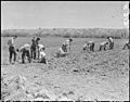
Parker High School students planting guayule at the Poston War Relocation Center on April 9, 1942.
-
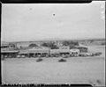
Parker's main street on April 9, 1942.
-
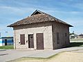
The Old Parker Jail was built in 1914 and located in Pop Harvey City Park. It was listed on the National Register of Historic Places on April 3, 1975, Reference #75000369.
-
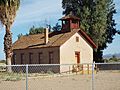
The Old Presbyterian Church a.k.a. Mojave Indian Presbyterian Mission Church, located on the South West corner of 2nd Ave., was built in 1917. It was listed in the National Register of Historic Places on June 3, 1971, Reference #71000122.


See also
 In Spanish: Parker (Arizona) para niños
