
Poston, Arizona facts for kids
Quick facts for kids
Poston, Arizona
|
|
|---|---|

Location in La Paz County and the state of Arizona
|
|

Poston, Arizona
Location in Arizona

Poston, Arizona
Location in the United States
|
|
| Country | |
| State | |
| County | La Paz |
| Area | |
| • Total | 1.38 sq mi (3.56 km2) |
| • Land | 1.38 sq mi (3.56 km2) |
| • Water | 0.00 sq mi (0.00 km2) |
| Elevation | 335 ft (102 m) |
| Population
(2020)
|
|
| • Total | 183 |
| • Density | 133.09/sq mi (51.40/km2) |
| Time zone | UTC-7 (MST (no DST)) |
| ZIP code |
85371
|
| Area code(s) | 928 |
| FIPS code | 04-57170 |
| GNIS feature ID | 0009680 |
Poston is a small community in La Paz County, Arizona, United States. It's known as a census-designated place (CDP), which means it's a special area defined for gathering population information. In 2020, about 183 people lived there.
Poston is most famous for its important role during World War II. It was the location of one of the largest internment camps in the United States.
Contents
Poston's History: A World War II Story
During World War II, the United States government created special camps to hold people of Japanese descent. This happened because of fears about national security after the attack on Pearl Harbor. Many Japanese-Americans, including children, were forced to leave their homes and live in these camps.
The Poston War Relocation Center
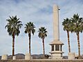
The camp in Poston was called the Poston War Relocation Center. It was one of the biggest camps of its kind. Over 17,000 Japanese-Americans were held there for about three years. Imagine having to leave your home and live in a new place with thousands of others!
Today, a special monument stands at the site of the former camp. It helps us remember the people who lived there and the important history of this time.

Where is Poston Located?
Poston is in the western part of La Paz County, Arizona. It's in an area called the Parker Valley. The community is about 3 miles (5 kilometers) east of the Colorado River. This river forms the border between Arizona and California.
Mohave Road goes through Poston. If you go north on this road for about 15 miles (24 kilometers), you'll reach Parker. If you go south for about 28 miles (45 kilometers), you'll get to Ehrenberg. Poston is also located within the land of the Colorado River Indian Tribes.
Land Area
According to the United States Census Bureau, the Poston area covers about 1.4 square miles (3.6 square kilometers). All of this area is land, with no large bodies of water.
Who Lives in Poston?
| Historical population | |||
|---|---|---|---|
| Census | Pop. | %± | |
| 2020 | 183 | — | |
| U.S. Decennial Census | |||
In 2000, there were 389 people living in Poston. By 2020, the population had decreased to 183 people.
Population Details
In 2000, about 66% of the households in Poston had children under 18 living with them. The average household had about 3.85 people.
The population was quite young, with 42% of residents being under 18 years old. The median age was 23 years, which means half the people were younger than 23 and half were older.
See also
 In Spanish: Poston para niños
Images for kids
-
Memorial Monument at the Poston War Relocation Center
