
Sacramento Mountains (New Mexico) facts for kids
Quick facts for kids Sacramento Mountains |
|
|---|---|

The western escarpment of the Sacramento Mountains, looking south from Dog Canyon.
|
|
| Highest point | |
| Peak | Two unnamed areas (Benson Ridge and Corral Canyon) |
| Elevation | 9,695 ft (2,955 m) |
| Dimensions | |
| Length | 85 mi (137 km) N-S |
| Width | 42 mi (68 km) W-E |
| Geography | |

Location of the Sacramento Mountains within New Mexico
|
|
| Country | United States |
| Geology | |
| Type of rock | Limestone |
The Sacramento Mountains are a mountain range located in the south-central part of New Mexico, a state in the United States. These mountains are found just east of the city of Alamogordo in Otero County. A small part of the range also stretches into Lincoln County and Chaves County. The Sacramento Mountains are about 85 miles (137 km) long from north to south and 42 miles (68 km) wide from east to west.
Contents
What Are the Sacramento Mountains Like?
The Sacramento Mountains can be split into two main parts. The larger, northern section has most of the land and all the highest points, reaching over 7,500 feet (2,286 meters). The smaller, southeastern section connects to the Guadalupe Mountains.
Nearby areas include the Tularosa Basin to the west. To the northwest and northeast, you'll find Sierra Blanca and the Capitan Mountains. The Border Hills and the edge of the Pecos River valley are to the east. The Guadalupe Mountains are to the southeast, and Otero Mesa is to the south and southwest. The Rio Tularosa and the Rio Ruidoso rivers separate the Sacramentos from Sierra Blanca and the Capitan Mountains. Carlsbad Caverns National Park, famous for its caves, is located near the Guadalupe Mountains.
High Points and Western Edge
The western side of the main Sacramento Mountains has steep cliffs called escarpments. These cliffs lead up to a high ridge. The highest named point on this ridge is Cathey Peak, which is 9,645 feet (2,940 meters) tall. However, there are two even higher unnamed spots in the range, both around 9,695 feet (2,955 meters). One is near Sunspot, and the other is on Benson Ridge. From this high ridge, the mountains gently slope down to the east, slowly blending into the flat plains near Artesia.
How Were the Mountains Formed?
The Sacramento Mountains are mostly made of limestone. They were formed as a large block of land that tilted, with the eastern side dipping down. This range is the easternmost part of a large crack in the Earth's crust called the Rio Grande Rift.
Long ago, the rock layers in the Sacramento Mountains were connected to those in the San Andres Mountains, which are on the other side of the Tularosa Basin. The basin formed when the land between these two ranges dropped down. Also, gypsum from the Sacramento Mountains washes into the White Sands National Park, forming its famous white sand dunes. Unlike the Sacramentos, the nearby Sierra Blanca mountains were formed by volcanic rock.
What Can You Do in the Sacramento Mountains?
Most of the main Sacramento Mountains are part of the Lincoln National Forest. This forest offers many hiking trails and has officially protected wilderness areas. The northern part of the range is also home to the Mescalero Apache Indian Reservation, where Apache people have lived since the 1400s.
The mountains are a popular place for visitors. The town of Cloudcroft is a well-known resort, and Ruidoso on the northern edge is also popular for recreation. The National Solar Observatory is located on Sacramento Peak, which is midway down the western ridge.
Plants and Animals
The Sacramento Mountains are home to some special plants that are found nowhere else. These include the Sacramento prickly poppy (Argemone pinnatisecta), which is an endangered species, and the Sacramento Mountains thistle (Cirsium vinaceum), which is a threatened species.
Images for kids
-
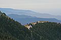
Looking south from the Sacramento Mountains
-
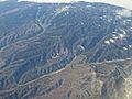
Aerial View of the Sacramento Mountains.
-
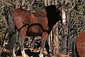
A wild horse in the forest of the Sacramento Mountains

.jpg)
_in_the_Sacramento_Mountains_of_New_Mexico,_United_States.jpg)
See also
 In Spanish: Sierra del Sacramento (Nuevo México) para niños
