Tularosa Basin facts for kids

The Tularosa Basin is a large, bowl-shaped area of land in southern New Mexico and West Texas. It's part of the Chihuahuan Desert and lies east of the Rio Grande river. This special type of basin is called a "graben basin," which means it formed when land dropped down between two faults.
Contents
Exploring the Tularosa Basin's Geography
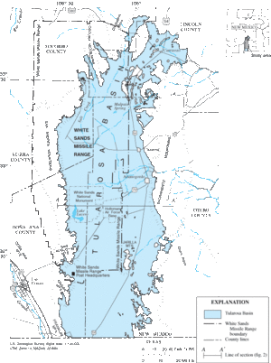
The Tularosa Basin is mostly in Otero County, New Mexico. It's a huge area, covering about 6,500 square miles (16,800 km²). This makes it much larger than the state of Connecticut!
The basin sits between two mountain ranges. To the east are the Sacramento Mountains. To the west are the San Andres and Oscura Mountains. The basin is about 150 miles (240 km) long from north to south. At its widest, it stretches about 60 miles (97 km) from east to west. Geologists say it's part of the Rio Grande Rift zone. This is an area where the Earth's crust is slowly pulling apart.
Cool Places to See in the Basin
The Tularosa Basin is home to many interesting spots. These include:
- White Sands National Park: Famous for its bright white sand dunes.
- Oliver Lee Memorial State Park: A beautiful park with canyons and history.
- The Carrizozo Malpais lava flow: A long, dark river of hardened lava.
- Holloman Air Force Base: An important military base.
- White Sands Missile Range: A large testing area. This range also includes the historic Trinity nuclear test Site, where the first atomic bomb was tested.
A stream called Tularosa Creek flows into the basin near the village of Tularosa. There's also a different Tularosa River far to the northwest in Catron County.
Water in the Tularosa Basin
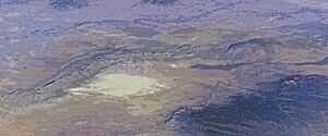
The Tularosa Basin is a "closed basin," which means no water flows out of it to the ocean. Water that falls as rain or snow either evaporates or soaks into the ground. Any surface water that remains collects in dry lake beds called "playas." The biggest of these is Lake Lucero, which is about 3,888 feet (1,185 meters) high. It's located at the southwest end of the White Sands dunes.
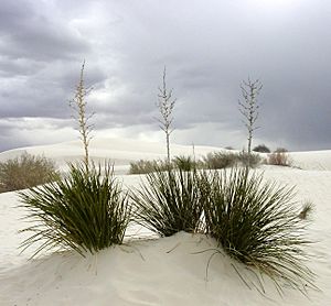
The White Sands are a massive area of white sand dunes. They cover about 275 square miles (710 km²). These dunes are made of gypsum crystals, which are a type of mineral. North of Lake Lucero, there are also large flat areas called "alkali flats." These flats produce more gypsum, which the wind then carries to form the dunes.
A Look Back: History of the Tularosa Basin
The Tularosa Basin has a rich history involving different groups of people.
Early Days: Apache, Spanish, and U.S. Settlers
When Spanish explorers first arrived in the Tularosa Basin, they found springs and small streams. These fed a green grassland on the eastern side of the basin. The Spanish tried some sheep ranching and mining. However, the Apache people largely controlled the area until the 1850s.
The United States military then set up forts to gain control. These included Fort Stanton (1855–1896) and Camp Comfort (1858–1859) at White Sands. With military protection, the first permanent settlement began in 1862. About 50 Hispanic farmers from the Rio Grande Valley moved to Tularosa. More American settlers and cattle ranchers from Texas started moving into the basin in the late 1870s. In 1969, a type of antelope called the Gemsbok was brought to the area.

Grasslands and Grazing Animals
The natural grasslands in the Tularosa Basin were once very lush. They could support many animals during wet years in the 1880s. When Americans first started raising cattle, some native grasses grew very tall. They could be as high as a horse's shoulder, or about 3 to 8 feet (1.0 to 2.5 meters) tall.
One cowboy in 1889 estimated that 85,000 cattle were in the basin. But he said this was "far too heavy a burden for the range." This means there were too many animals for the land to support. A severe drought followed for years. The grasslands never fully recovered from being overgrazed. This overgrazing continued for 75 years or more. It caused the topsoil to wash away and led to the land becoming more like a desert.
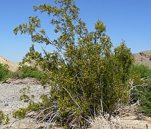
Even on the White Sands Missile Range, where cattle grazing stopped in 1945, you can still see the effects. Many areas that were once rich grasslands are now dry desert shrublands. The creosote bush—(Larrea tridentata) is now the most common plant there.
Salty Groundwater Challenges
Since there wasn't enough surface water for the cattle, ranchers started using groundwater. They pumped out the "sweet water" from underground. This caused the water levels to drop, leaving only brackish water, which is salty.
When this groundwater was used on the surface, it dissolved more salts. These salts then seeped back into the ground, making the underground water even saltier. By 2000, it was clear that the saltiness of the groundwater needed to be reduced.
So, in 2004, the Tularosa Basin National Desalination Research Facility was built in Alamogordo. This facility is a joint project to find ways to reduce salty water. It also works on new technologies for desalination. Desalination is the process of removing salt from water. This research is important because many underground water sources are becoming saltier due to farming and people using too much water.
Life in the Tularosa Basin: Ecology
The Tularosa Basin is part of the Chihuahuan Desert ecoregion. It used to have areas that were like the Great Plains grasslands. Because the basin is a closed area, many unique plants and animals have developed here. These are called endemic species, meaning they are found only in the Tularosa Basin.
Some examples include the White Sands pupfish (Cyprinodon tularosa) and the Oscura Mountains chipmunk. These creatures have adapted to live in this special environment.
Counties in the Tularosa Basin
While most of the Tularosa Basin is in Otero County, New Mexico, it also stretches into other counties. These include:

Cities, Towns, and Ghost Towns
Here are some of the places you can find in the Tularosa Basin:
- Alamogordo 32°54′N 105°58′W / 32.90°N 105.96°W
- Alvarado 32°05′N 106°08′W / 32.08°N 106.14°W
- Boles Acres 32°49′N 105°59′W / 32.81°N 105.99°W
- Carrizozo 33°38′N 105°53′W / 33.64°N 105.88°W
- Coane
- Desert 32°07′N 106°07′W / 32.12°N 106.11°W
- Elwood 32°11′N 106°05′W / 32.18°N 106.08°W
- Estey City
- Holloman AFB 32°49′N 105°56′W / 32.82°N 105.94°W ZIP Code: 88330
- Kearney 32°59′N 105°59′W / 32.98°N 105.99°W
- La Luz 32°59′N 105°56′W / 32.98°N 105.94°W ZIP Code: 88337
- Lovelace 33°28′N 106°01′W / 33.46°N 106.02°W
- Monista 32°50′N 106°04′W / 32.83°N 106.07°W
- Omlee 32°50′N 105°58′W / 32.84°N 105.97°W
- Orogrande 32°22′N 106°05′W / 32.37°N 106.08°W ZIP Code: 88342
- Oscura
- Point of Sands
- Polly
- Salinas
- Three Rivers 33°19′N 106°04′W / 33.32°N 106.07°W ZIP Code: 88352
- Tularosa 33°04′N 106°01′W / 33.07°N 106.02°W ZIP Code: 88352
- Turquoise 32°27′N 106°02′W / 32.45°N 106.03°W
- Valmont 32°45′N 105°59′W / 32.75°N 105.99°W
- White Sands 32°23′N 106°29′W / 32.38°N 106.48°W
See also
 In Spanish: Cuenca del Tularosa para niños
 | Anna J. Cooper |
 | Mary McLeod Bethune |
 | Lillie Mae Bradford |


