Doña Ana County, New Mexico facts for kids
Quick facts for kids
Doña Ana County
|
|||
|---|---|---|---|

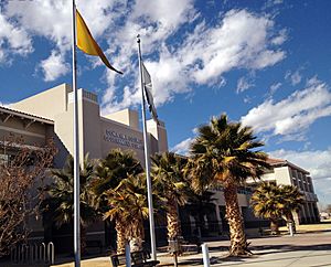
Doña Ana County Government Center
|
|||
|
|||

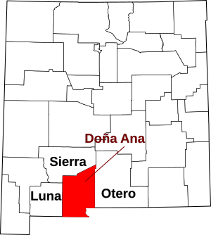
Location within the U.S. state of New Mexico
|
|||
 New Mexico's location within the U.S. |
|||
| Country | |||
| State | |||
| Founded | 1852 | ||
| Seat | Las Cruces | ||
| Largest city | Las Cruces | ||
| Area | |||
| • Total | 3,814 sq mi (9,880 km2) | ||
| • Land | 3,808 sq mi (9,860 km2) | ||
| • Water | 6.9 sq mi (18 km2) 0.2%% | ||
| Population
(2020)
|
|||
| • Total | 219,561 | ||
| • Density | 55/sq mi (21/km2) | ||
| Time zone | UTC−7 (Mountain) | ||
| • Summer (DST) | UTC−6 (MDT) | ||
| Congressional district | 2nd | ||
Doña Ana County (Spanish: Condado de Doña Ana) is a county located in the southern part of New Mexico, United States. A county is like a smaller region within a state. In 2020, about 219,561 people lived here. This makes it the second-most populated county in New Mexico.
The main city and county seat is Las Cruces. It is the second-largest city in New Mexico, after Albuquerque. In 2020, Las Cruces had about 111,385 residents.
The county got its name from Doña Ana Robledo. She passed away in 1680 while trying to escape the Pueblo Revolt. Doña Ana County is special because it's one of only two counties in the U.S. with a special mark (called a diacritical mark) in its name. The other is Coös County in New Hampshire. Both counties are also close to international borders. Doña Ana County borders Mexico, and Coös County borders Canada.
Doña Ana County is part of the Las Cruces, NM Metropolitan Statistical Area. This area is also linked to the larger El Paso–Las Cruces, TX–NM Combined Statistical Area.
The county shares borders with other counties in New Mexico: Luna, Sierra, and Otero. To the east and southeast, it borders El Paso County, Texas in Texas. The state of Chihuahua, Mexico, is to the south.
In 2020, about 67.3% of the people in Doña Ana County were of Hispanic background. This makes it New Mexico's largest county with a majority Hispanic population.
Contents
Geography
Doña Ana County covers a total area of about 3,814 square miles. Most of this area, 3,808 square miles, is land. Only a small part, about 6.9 square miles, is covered by water.
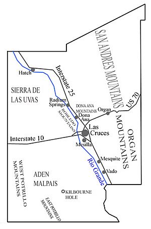
The county has many interesting natural features. The Mesilla Valley is a flat area along the Rio Grande river that runs through the middle of the county. The Organ Mountains are a striking mountain range on the eastern side of the county.
Other mountain ranges you can find here include the Robledo Mountains, Doña Ana Mountains, and Sierra de las Uvas. The southern part of the San Andres Mountains is also in the county. There are also the East Potrillo Mountains and West Potrillo Mountains. Two smaller, separate mountains are Tortugas (or A) Mountain and Picacho Peak.
The county also has the Aden Malpais, which is one of New Mexico's four large areas of hardened lava. You can also find Kilbourne Hole here, which is one of the world's largest maare volcanoes. A maare volcano is a wide, low-relief volcanic crater formed by an explosion.
Neighboring Areas
Doña Ana County shares its borders with these counties and areas:
- Luna County – to the west
- Sierra County – to the north
- Otero County – to the east
- El Paso County, Texas – to the southeast
- Ascensión, Chihuahua, Mexico – to the south
- Juárez, Chihuahua, Mexico – to the south
Protected Natural Places
Several important protected areas are found partly within Doña Ana County:
- El Camino Real de Tierra Adentro National Historic Trail (a historic trail)
- Prehistoric Trackways National Monument (a place with ancient animal tracks)
- San Andres National Wildlife Refuge (a safe place for wildlife)
- White Sands National Park (a famous park with white gypsum sands)
Population Information
| Historical population | |||
|---|---|---|---|
| Census | Pop. | %± | |
| 1860 | 6,239 | — | |
| 1870 | 5,864 | −6.0% | |
| 1880 | 7,612 | 29.8% | |
| 1890 | 9,191 | 20.7% | |
| 1900 | 10,187 | 10.8% | |
| 1910 | 12,893 | 26.6% | |
| 1920 | 16,548 | 28.3% | |
| 1930 | 27,455 | 65.9% | |
| 1940 | 30,411 | 10.8% | |
| 1950 | 39,557 | 30.1% | |
| 1960 | 59,948 | 51.5% | |
| 1970 | 69,773 | 16.4% | |
| 1980 | 96,340 | 38.1% | |
| 1990 | 135,510 | 40.7% | |
| 2000 | 174,682 | 28.9% | |
| 2010 | 209,233 | 19.8% | |
| 2020 | 219,561 | 4.9% | |
| U.S. Decennial Census 1790–1960 1900–1990 1990–2000 2010–2020 |
|||
2010 Census Facts
In 2010, there were 209,233 people living in Doña Ana County. There were about 75,532 households. A household is a group of people living together in one home.
The population density was about 55 people per square mile. This means that, on average, 55 people lived in every square mile of land.
The people living in the county came from many different backgrounds. About 74.1% were white, 1.7% were Black or African American, and 1.5% were American Indian. About 65.7% of the population identified as Hispanic or Latino.
The average age of people in the county was 32.4 years old. This means half the people were younger than 32.4, and half were older.
2000 Census Facts
In 2000, the county had 174,682 people. The population density was about 46 people per square mile.
About 67.8% of the people were White, and 63.4% were Hispanic or Latino.
About 29.7% of the population was under 18 years old. About 13.3% were between 18 and 24 years old. The median age was 30 years.
Communities
Doña Ana County has several cities, towns, and villages. It also has many smaller communities called census-designated places.
Cities
- Anthony
- Las Cruces (This is the county seat, where the main government offices are)
- Sunland Park
Towns
Village
Census-designated places
- Berino
- Butterfield Park
- Chamberino
- Chaparral
- Doña Ana
- Fairacres
- Garfield
- La Mesa
- La Union
- Mesquite
- Organ
- Picacho Hills
- Placitas
- Radium Springs
- Rincon
- Rodey
- Salem
- San Miguel
- San Pablo
- San Ysidro
- Santa Teresa
- Tortugas
- University Park
- Vado
- White Sands
Other places
Ghost towns
Education
Students in Doña Ana County attend schools in these districts:
- Gadsden Independent Schools
- Hatch Valley Municipal Schools
- Las Cruces Public Schools
See also
 In Spanish: Condado de Doña Ana para niños
 | William M. Jackson |
 | Juan E. Gilbert |
 | Neil deGrasse Tyson |


