
Kilbourne Hole facts for kids
Kilbourne Hole is a special kind of volcano called a maar. It's located about 30 miles (48 km) west of the Franklin Mountains near El Paso, Texas, in New Mexico. Another similar maar, called Hunt's Hole, is just two miles south. These "holes" are rare because they are volcanic craters without the usual tall, mountainous rim you might expect from a volcano.
Scientists believe Kilbourne Hole formed between 24,000 and 80,000 years ago. In 1975, it was recognized as a National Natural Landmark, which means it's a very important natural site.
Contents
How Kilbourne Hole Formed
Kilbourne Hole and Hunt's Hole are part of a larger volcanic area called the Potrillo volcanic field. This area is also part of the Rio Grande rift, a place where the Earth's crust is slowly being pulled apart. This pulling creates deep basins and causes volcanic activity.
A maar volcano forms in a very explosive way. It happens when hot, melted rock (called magma) rises from deep inside the Earth and hits underground water. The magma heats the water so much that it turns into super-hot steam. This steam builds up huge pressure, eventually causing a massive explosion that blows out the ground above it. This explosion creates a deep, wide crater.
Kilbourne Hole erupted through loose sediments and a thin layer of older volcanic rock. Unlike many volcanoes, it has a low rim made of the material that was blasted out during the eruption.
Exploring the Crater

Kilbourne Hole is quite large! It's about 1.5 miles (2.4 km) wide by 2.1 miles (3.4 km) long and about 443 feet (135 m) deep.
The crater is over a mile wide and more than 300 feet (91 m) deep. Most of its edges are surrounded by crumbling basalt cliffs. These cliffs look a bit like the famous Devils Postpile National Monument because they have reddish-purple, six-sided columns. However, the cliffs at Kilbourne Hole are shorter, about 40 feet (12 m) high. At the bottom of these cliffs, you'll find piles of broken basalt rocks.
The eastern and northern edges of the hole have low piles of material that were blasted out during the eruption. This material includes special rocks called "dropstones" and many "xenoliths." Scientists study these xenoliths to learn about what's deep inside the Earth.
Hunt's Hole, which is nearby, is a bit smaller. It also has basalt cliffs and layers of ash. Sand dunes have formed on the east sides of both craters, rising about 100 feet (30 m) above the desert floor. At the bottom of each crater, there's a dry lakebed.
Amazing Rocks from Deep Earth: Xenoliths

Kilbourne Hole is famous for its many xenoliths. These are pieces of rock from deep inside the Earth that were carried to the surface by the volcanic eruption. Think of them as natural samples from places we can't reach with drills or mines!
These xenoliths come from both the Earth's mantle (the layer below the crust) and the lower crust. They are most common on the northern and eastern edges of the crater. Because they offer a rare peek at what's deep underground, they are incredibly important for scientists.
Many of the mantle xenoliths at Kilbourne Hole are made of a rock called lherzolite. This rock is mostly green with black flecks. Sometimes, another rock called peridotite is also found.
The rocks from the deep crust include different types of granulite. Scientists believe these rocks traveled to the surface very quickly, perhaps in less than three days! This quick journey meant they didn't change much from when they first formed billions of years ago. Studying them helps us understand the Earth's history and how it works.
Interestingly, Hunt's Hole has almost no xenoliths, but another nearby maar called Potrillo maar does have them.
-
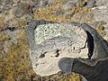
A mantle xenolith (dark rock) stuck inside basalt.
-
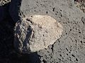
Several mantle xenoliths.
-
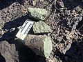
A xenolith from the lower crust.


Astronaut Training at Kilbourne Hole

Did you know that Kilbourne Hole was used by NASA to train astronauts? Between 1969 and 1971, many Apollo astronauts visited this site to learn about geology. This training helped them prepare for their missions to the Moon, where they would collect rock samples and study the lunar surface.
Some of the famous astronauts who trained here included Apollo 12's Pete Conrad and Alan Bean, Apollo 14's Alan Shepard and Edgar Mitchell, Apollo 15's David Scott and James Irwin, Apollo 16's John Young and Charlie Duke, and Apollo 17's Gene Cernan and Jack Schmitt.
Visiting Kilbourne Hole
Kilbourne Hole is part of the Organ Mountains–Desert Peaks National Monument and is managed by the Bureau of Land Management. You can get there by taking Doña Ana County Road A-011, driving about 8 miles (13 km) west from the railroad tracks. The hole will be "on the right, past the big tan dirt bank." Keep in mind that some of the land inside the hole is private property. Hunt's Hole is about 2 miles (3.2 km) south on road A-013.

