
Franklin Mountains (Texas) facts for kids
Quick facts for kids Franklin Mountains |
|
|---|---|

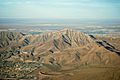
Aerial view of the Franklin Mountains from the south, with El Paso's Scenic Drive at the bottom, and New Mexico's Organ Mountains on the horizon in the distance
|
|
| Highest point | |
| Peak | North Franklin Peak |
| Elevation | 7,192 ft (2,192 m) |
| Geography | |
| Country | United States |
| Geology | |
| Orogeny | Laramide orogeny |
| Age of rock | Cretaceous |
| Type of rock | Sedimentary, Igneous |
The Franklin Mountains are a small mountain range located mostly in Texas, extending north into New Mexico. They are about 23 miles (37 km) long and 3 miles (4.8 km) wide. These mountains were once known as Las Sierras de los Mansos.
The highest point in the range is North Franklin Peak, which stands at 7,192 feet (2,192 m) tall. A large part of these mountains is protected as Franklin Mountains State Park, a popular place for outdoor activities.
Contents
How the Franklin Mountains Formed
The Franklin Mountains were created by powerful forces deep within the Earth. They are known as "tilted-block fault mountains." This means that large blocks of the Earth's crust tilted and moved along cracks, called faults.
Ancient Rocks and Earth's Movements
The mountains are mostly made of sedimentary rock. This type of rock forms from layers of sand, mud, and tiny bits of ancient sea creatures that pile up over millions of years. You can also find some igneous rock here, which forms when molten rock (magma) cools and hardens.
The oldest rocks in Texas, called Precambrian rocks, are found in the Franklin Mountains. These rocks are incredibly old, about 1.25 billion years!
The mountains' shape today is mostly due to the Earth's crust stretching. This stretching happened over the last 10 million years and is linked to the Rio Grande rift. This is a huge crack in the Earth's crust that is slowly pulling North America apart.
Older movements also played a role. Between 85 and 45 million years ago, a period called the Laramide orogeny caused the Earth's crust to fold and uplift. This also helped shape the Franklin Mountains long ago.
Franklin Mountains State Park
Much of the Franklin Mountains range is part of the Franklin Mountains State Park. This park is one of the largest urban state parks in the United States. It offers many activities like hiking, rock climbing, and enjoying nature. Visitors can explore the unique desert environment and see amazing views of the surrounding area.
Images for kids
-
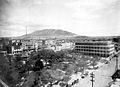
View of the south end of Franklin Mountains from El Paso, showing the abrupt termination of the range, its westward dip slope and terraced bolson deposits on each side. (1908)
-
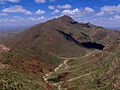
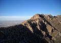
North Franklin Peak, looking northeast from South Franklin Mountain
-
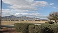
South and North Franklin mountains, shown left to right, El Paso, Texas, as seen from Fort Bliss. The Organ Mountains can be glimpsed to the north, in the right part of the image.
-
View of South Franklin Mountain (aka Mount Franklin) (29 March 2009)
-
Franklin Mountains with Northwest El Paso in the background


See also
 In Spanish: Sierra de los Mansos para niños
