
Franklin Mountains State Park facts for kids
Quick facts for kids Franklin Mountains State Park |
|
|---|---|

Entrance to Tom Mays unit
|
|

Franklin Mountains State Park
Location in Texas
|
|
| Nearest city | El Paso |
| Length | 23 mi (37 km) |
| Width | 3 mi (4.8 km) |
| Area | 24,247 acres (98.12 km2) |
| Elevation | 5,426 ft (1,654 m) |
| Designated | 1987 |
| Named for | Benjamin Franklin Coons |
| Administrator | Texas Parks and Wildlife |


Franklin Mountains State Park is a fantastic Texas state park located in El Paso, Texas, in the United States. It's a huge park with mountains, and its highest point reaches about 7,192 feet tall! This park is one of the biggest parks found completely inside a city in the whole country. It covers over 24,000 acres of land. Franklin Mountains State Park is open all year. You can enjoy hiking, mountain biking, picnicking, and driving along scenic roads to see amazing views.
Contents
History of the Franklin Mountains
For more than 12,000 years, people have used the natural resources in the Franklin Mountains. Ancient Native Americans and other travelers crossed the area between the Franklin Mountains and the Juarez Mountains. This gap is now where Ciudad Juárez in Mexico and El Paso are located. You can still see Pictograms (rock drawings) and mortar pits (holes used for grinding food) that show people lived here a very long time ago.
The mountains are probably named after Benjamin Franklin Coons. He bought a ranch in what is now El Paso in 1849. At first, the area was called Coons Ranch. By 1851, the settlement started using Coons' middle name and was called Franklin. Even though the town was officially named El Paso in 1852, locals kept calling it Franklin through the 1850s.
Mining for Tin in the Mountains
From 1909 to 1915, a company called the El Paso Tin Mining and Smelting Company operated a tin mine here. It was on the northeast side of North Franklin Mountain. This mine was special because it was the only tin mine ever found in the U.S. However, it didn't make much money and eventually closed down.
Protecting the Park Land
People started trying to protect the Franklin Mountains as early as 1925. In 1979, a company wanted to build houses on the mountains and even built a road up them. A local group called the Wilderness Park Coalition worked hard to save the mountains. They convinced the Texas Legislature to protect the mountains in 1979.
Even with this success, the law at the time didn't allow money for the park's development or upkeep. The land for the park was officially bought in 1981. Later, in 1985, changes were made to the law, and a plan for the park was created. Finally, Franklin Mountains State Park opened to the public in 1987.
Geology of the Franklin Mountains
The Franklin Mountains are about 23 miles long and 3 miles wide. They stretch from El Paso all the way into New Mexico. These mountains were formed because the Earth's crust stretched apart. This happened during a time called the Cenozoic era, linked to the Rio Grande rift.
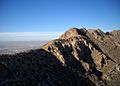
The oldest rocks in Texas, which are a billion years old, can be found here. Geologists call these "tilted-block fault mountains." The highest point is North Franklin Mountain, standing tall at 7,192 feet. You can reach North Franklin Peak by following a trail that starts east of Mundy's Gap. The mountains are mostly made of sedimentary rock, with some igneous (volcanic) rocks mixed in.
Ecology: Plants and Animals
Franklin Mountains State Park is part of the Chihuahuan Desert. Even though the park is inside a city, the plants and animals you find here are typical of the rest of the desert.
Plants of the Desert
Common plants you'll see include barrel cactus, yucca, and colorful Mexican and California poppies. Along the springs on the mountain slopes, you can find trees like cottonwood, hackberry, juniper, and oak.
Wildlife in the Park
Many different animals live in the park. You might spot larger mammals like mule deer, mountain lions, and ring-tailed cats. There are also many types of smaller rodents. For bird watchers, the park is home to golden eagles, owls, hawks, and a wide variety of smaller birds.
Recreation and Fun Activities
Franklin Mountains State Park is open all year for fun activities. The park has limited development, so much of the land is natural and far from paved roads.
Trails and Climbing
Two hiking trails can be reached from Woodrow Bean Transmountain Drive. There are also plans to create a network of 100 miles of hiking trails! If you like Rock climbing, it's allowed in the park. Popular climbing spots are located in McKelligon Canyon, which is also where the park headquarters is.
Camping and Picnics
In the Tom Mays Unit of the park, you'll find five camping areas. These spots also have picnic facilities, perfect for a meal outdoors with friends and family.
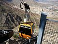
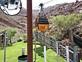
Wyler Aerial Tramway
The Wyler Aerial Tramway is a special aerial tramway located in Franklin Mountains State Park. It was operated by the Texas Parks and Wildlife Department. The tramway complex covers 196 acres on the east side of the mountains. The gondolas (small cabins) travel along steel cables to Ranger Peak, which is 5,632 feet above sea level. The ride takes about four minutes and lifts you up 940 feet higher than where you started! As of September 2018, the tram is closed to the public.
Images for kids
-
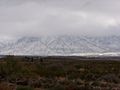
Franklin Mountain Snow
-
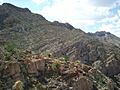
Eastern side of the Franklin Mountains by Ranger Peak
-
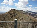
Looking north from Ranger Peak
-
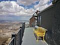
Ranger Peak
-
Franklin Mountains with Northwest El Paso in the background
-
Wyler Aerial Tramway
-
Wyler Aerial Tramway


