White Sands, New Mexico facts for kids
Quick facts for kids
White Sands, New Mexico
|
|
|---|---|

Location of White Sands, New Mexico
|
|
| Country | United States |
| State | New Mexico |
| County | Doña Ana |
| Area | |
| • Total | 4.22 sq mi (10.94 km2) |
| • Land | 4.22 sq mi (10.94 km2) |
| • Water | 0.00 sq mi (0.00 km2) |
| Elevation | 4,236 ft (1,291 m) |
| Population
(2020)
|
|
| • Total | 926 |
| • Density | 219.22/sq mi (84.63/km2) |
| Time zone | UTC-7 (Mountain (MST)) |
| • Summer (DST) | UTC-6 (MDT) |
| ZIP code |
88002
|
| Area code(s) | 575 |
| FIPS code | 35-84845 |
| GNIS feature ID | 2409585 |
White Sands is a special community in Doña Ana County, New Mexico, United States. It is known as a census-designated place (CDP). This means it is a place that the government counts as a separate community for population surveys. White Sands is the main living area for people who work at the White Sands Missile Range. In 2020, about 926 people lived here. It is also part of the larger Las Cruces area.
Contents
Location and Size
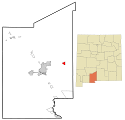
White Sands is in the eastern part of Doña Ana County. It is at the southern end of the White Sands Missile Range. The community is about 4 miles south of U.S. Route 70. It is also about 27 miles east of Las Cruces, which is the main city in the county. The famous White Sands National Park is about 34 miles northeast, along US 70.
The total area of White Sands is about 4.22 square miles (10.94 square kilometers). All of this area is land.
The Unique White Sands Desert
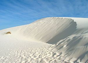
The desert near White Sands is in a large valley called the Tularosa Basin in New Mexico. What makes its white sands special is that they are not made of quartz, like most desert sands. Instead, they are made of a mineral called gypsum. Gypsum is a type of hydrated calcium sulfate.
Unlike other deserts, the sand here feels cool to the touch. This is because moisture on the surface evaporates quickly. Also, the white sand reflects the sun's rays instead of absorbing them. This area is about 3,888 feet (1,185 meters) above sea level. It has about 171 square miles (442 square kilometers) of sand dunes. This makes it the world's largest surface area covered by gypsum.
How the Gypsum Desert Formed
Gypsum is a common mineral, but it usually dissolves easily in water. So, it is rare to see it on the surface like this. This desert began to form about 100 million years ago. At that time, the area was covered by a shallow sea. As the sea slowly dried up, it left behind salty lakes. These lakes eventually evaporated in the sun. They left behind thick layers of salt and gypsum on the old seabed.
The Sacramento and San Andres Mountains formed about 250 million years ago. The Tularosa Basin is located between these mountains. Huge movements in the Earth's crust lifted the land, including the gypsum deposits. This happened about 70 million years ago. Rain and melted snow from the mountains caused the gypsum to dissolve. This gypsum-rich water then flowed down the mountainsides.
The gypsum solution collected in Lake Lucero, which is the lowest part of the Tularosa Basin. Water in this lake can only escape by evaporating. As the water evaporates, it leaves behind thin layers of crystallized gypsum. These crystals are called selenite. Over time, weather broke these crystals into fine, sandy grains. Winds then carried these grains further into the basin. The grains piled up into steep dunes that can be as tall as 50 feet (15 meters). The winds continue to shape new dunes. They also move small amounts of gypsum grains up to 30 feet (9 meters) each year.
This constant movement still happens today. The sandy soil is also very alkaline, and there is little rainfall. These conditions make it hard for many plants to grow here. This is why the desert looks so empty and unique.
Education for Kids
Children living in White Sands attend schools that are part of the Las Cruces Public Schools district. The White Sands School is located right on the White Sands Missile Range property.
See also
 In Spanish: White Sands (Nuevo México) para niños
 | John T. Biggers |
 | Thomas Blackshear |
 | Mark Bradford |
 | Beverly Buchanan |


