East Potrillo Mountains facts for kids
Quick facts for kids East Potrillo Mountains |
|
|---|---|

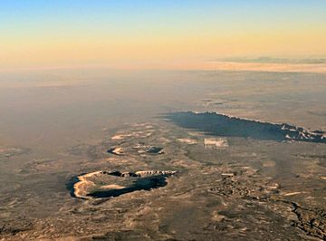
Kilbourne and Hunts Holes and East Potrillo Mountains
|
|
| Highest point | |
| Peak | Unnamed point on ridge |
| Elevation | 5,344 ft (1,629 m) |
| Dimensions | |
| Length | 10 mi (16 km) NNW-SSE |
| Width | 1–2 mi (1.6–3.2 km) WSW-ENE |
| Geography | |
| Country | United States |
| State | New Mexico |
| County | Doña Ana |
| Range coordinates | 31°52′36″N 107°0′43″W / 31.87667°N 107.01194°W |
| Borders on | West Potrillo Mountains-W Rio Grande Valley (New Mexico)-E Cox Peak, Mt. Riley, Potrillo volcanic field-N |
| Geology | |
| Type of rock | Uplifted fault block, with Cretaceous limestone and siltstones overlaying Permian limestones |
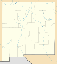
The East Potrillo Mountains are a mountain range in New Mexico, United States. They are located in the southern part of Doña Ana County. These mountains are about 25 miles (40 km) west of El Paso, Texas. They are also about 30 miles (50 km) southwest of Las Cruces, New Mexico. The very southern tip of the range is close to the border with Mexico. Most of the land here is managed by the Bureau of Land Management. You can reach the area using New Mexico State Road 9 and some unpaved county roads.
Contents
How the Mountains Formed (Geology)
The East Potrillo Mountains are like a giant block of land that was pushed up and tilted. They sit near the edge of the Rio Grande Rift. This "rift" is a huge crack in the Earth's crust. It stretches from Colorado all the way into Mexico.
In southern New Mexico, this rift has created large basins, which are like big dips in the land. The Mimbres basin is to the west of these mountains. The Mesilla basin is to the east. The East Potrillo Mountains sit on a raised block of land between these two basins. This pushing up of the mountains happened a long time ago, in the late Tertiary period. The eastern side of the mountains has a steep cliff, called a scarp. This was formed by an active fault line.
The oldest rocks in these mountains are sedimentary rocks. These include limestone, dolomites, and silty layers from the Middle Permian age. These layers are about 950 feet (300 m) thick. On top of these are layers of younger rocks from the Lower Cretaceous period. These include more limestone, siltstone, sandstone, and conglomerate. These younger rocks are about 1,800 feet (570 m) thick in the north. They get thinner as you go south. The very top layers are made of Quaternary deposits. These include sand that has been blown by the wind.
Weather and Climate
The East Potrillo Mountains are located in the Chihuahuan Desert. This means the climate is very dry and has big temperature changes. Records from nearby El Paso, Texas, show the average high temperature is about 77 degrees Fahrenheit (25 Celsius). The average low is about 50 degrees Fahrenheit (10 Celsius).
The hottest month is June, with average highs around 96 degrees Fahrenheit (36 Celsius). The coldest month is January, with average lows around 30 degrees Fahrenheit (-1 Celsius). The area gets about 8.81 inches (22 cm) of rain each year. Most of this rain falls during the summer, from June to September. Sometimes, it can snow in the winter.
Plants and Animals (Ecology)
Life in the East Potrillo Mountains is tough because of the extreme conditions. Water is very important here. There are no natural streams that flow all year round. There is also very little permanent water, except for some tanks and ponds made by people. Rain quickly dries up, runs off, or soaks into the ground. This leaves little water for plants or animals.
Slopes that face south or west get more sun. They also lose water faster than slopes facing north or east. This can cause different types of plants to grow on different sides of the mountains.
The soil on the mountains is usually rocky and thin. In the flat areas below, the soil is deeper. It often has sand dunes created by the wind.
Plant Life
The plants here are typical of the Chihuahuan desert. You'll find desert scrublands and grasslands. Common shrubs include:
- Creosote bush (Larrea tridentata)
- Honey mesquite (Prosopis glandulosa)
- Soaptree yucca (Yucca elata)
- Four winged saltbush (Atriplex canescens)
Common grasses include:
- Black grama (Bouteloua eriopoda)
- Blue grama (Bouteloua gracilis)
- Sideoats grama (Bouteloua curtipendula)
- Alkali sacaton (Sporobolus airoides)
Animal Life
Many animals live in these mountains, even with the tough conditions.
- Mammals you might see include:
- Mule deer (Odocoileus hemionus)
- Coyotes (Canis latrans)
- Black-tailed jackrabbit (Lepus californicus)
- Desert cottontail (Sylvilagus auduboni)
- Kangaroo rats (Dipodomys merriami and Dipodomys spectabilis)
- Birds that live here are:
- Reptiles you might find are:
- Amphibians include:
Things to See and Do
The East Potrillo Mountains don't get many visitors. This is because the land is rough, and there isn't much water or shade. The mountain range is long and narrow, stretching from north-northwest to south-southeast. The highest point is about 5,300 feet (1,615 m) high. This is almost 1,000 feet (300 m) higher than the flat lands to the east.
Nearby peaks like Mount Riley and Cox Peak are popular for hikers. They offer great views of the East Potrillo Mountains and the West Potrillo Mountains. Even though these peaks are close, they are made of igneous (volcanic) rock. They are more closely related to the West Potrillo Mountains.
Volcanic Craters
One interesting feature nearby are several "maars." These are special craters formed by volcanic explosions. They are located about 5–10 miles north and east of the mountains. Famous maars include Kilbourne Hole, Hunt's Hole, and Phillips Hole. Scientists think these craters are between 24,000 and 50,000 years old. They are part of the larger Potrillo volcanic field. This field also includes the West Potrillo Mountains and the Aden lava flows.
The Name and Protection
The name "Potrillo" means "colt" in Spanish. The Bureau of Land Management looked into making a part of these mountains a Wilderness Study Area. This would protect the land more strictly. They decided not to give full wilderness status to a large area that includes the nearby West Potrillo Mountains. This was partly because of the need for a "buffer" zone along the border.
 | George Robert Carruthers |
 | Patricia Bath |
 | Jan Ernst Matzeliger |
 | Alexander Miles |


