
Santa Teresa, New Mexico facts for kids
Quick facts for kids
Santa Teresa, New Mexico
|
|
|---|---|

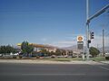
Main Street in Santa Teresa, June 2013
|
|

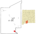
Location within Dona Ana County and New Mexico
|
|

Santa Teresa, New Mexico
Location in the United States

Santa Teresa, New Mexico
Location in New Mexico
|
|
| Country | United States |
| State | New Mexico |
| County | Dona Ana |
| Area | |
| • Total | 8.85 sq mi (22.92 km2) |
| • Land | 8.85 sq mi (22.92 km2) |
| • Water | 0.00 sq mi (0.00 km2) |
| Elevation | 3,937 ft (1,200 m) |
| Population
(2020)
|
|
| • Total | 5,044 |
| • Density | 569.94/sq mi (220.05/km2) |
| Time zone | UTC-7 (Mountain (MST)) |
| • Summer (DST) | UTC-6 (MDT) |
| ZIP codes |
88008, 88063
|
| Area code(s) | 575 |
| FIPS code | 35-70700 |
| GNIS feature ID | 2409282 |
Santa Teresa is a community located in Dona Ana County, New Mexico, in the United States. It is known for its important border crossing, the Santa Teresa Port of Entry. This community is part of the Las Cruces area, but it is actually much closer to El Paso, Texas. In 2020, about 5,044 people lived there. The National Weather Service office for extreme western Texas and Southwestern New Mexico is also located in Santa Teresa.
Contents
History of Santa Teresa
In 2015, the people of Santa Teresa asked the Dona Ana County leaders to make their community an official city. Another nearby town, Sunland Park, tried to take over Santa Teresa. However, the county leaders decided that Sunland Park had no right to do this. Sunland Park then took this decision to the New Mexico Supreme Court.
Geography of Santa Teresa
Santa Teresa covers an area of about 10.9 square miles (28 km2). All of this area is land, with no water.
People and Population
| Historical population | |||
|---|---|---|---|
| Census | Pop. | %± | |
| 2020 | 5,044 | — | |
| U.S. Decennial Census | |||

In 2000, there were 2,607 people living in Santa Teresa. These people lived in 952 households, with 755 of them being families. The community had about 238 people per square mile.
Most people in Santa Teresa were White (82.09%). About 55.58% of the population identified as Hispanic or Latino.
Many households (40.0%) had children under 18 living with them. Most households (68.0%) were married couples. The average household had 2.74 people, and the average family had 3.11 people.
The population included people of all ages. About 27.8% were under 18 years old. The average age was 36 years.
The median income for a household in Santa Teresa was $61,500. For families, the median income was $66,833. Only a small number of families (2.2%) and people (1.6%) lived below the poverty line.

Education in Santa Teresa
The Gadsden Independent School District runs the public schools in Santa Teresa. These include:
- Santa Teresa High School
- Santa Teresa Middle School
- Santa Teresa Elementary School
Infrastructure and Services
Water in Santa Teresa is provided by the Camino Real Regional Utility Authority. The community also has its own airport, the Doña Ana County International Jetport.
Images for kids
-
Main Street in Santa Teresa, June 2013
-
Location within Dona Ana County and New Mexico
See also
 In Spanish: Santa Teresa (Nuevo México) para niños
