Chaparral, New Mexico facts for kids
Quick facts for kids
Chaparral, New Mexico
|
|
|---|---|

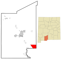
Location of Chaparral, New Mexico
|
|
| Country | United States |
| State | New Mexico |
| Counties | Doña Ana, Otero |
| Area | |
| • Total | 59.06 sq mi (152.98 km2) |
| • Land | 59.06 sq mi (152.98 km2) |
| • Water | 0.00 sq mi (0.00 km2) |
| Elevation | 4,082 ft (1,244 m) |
| Population
(2020)
|
|
| • Total | 16,551 |
| • Density | 280.22/sq mi (108.19/km2) |
| Time zone | UTC-7 (Mountain (MST)) |
| • Summer (DST) | UTC-6 (MDT) |
| ZIP codes |
88081
|
| Area code(s) | 575 |
| FIPS code | 35-14250 |
| GNIS feature ID | 2408012 |
Chaparral is a community located in the state of New Mexico, USA. It is found in both Doña Ana and Otero counties. In 2020, about 16,551 people lived there.
Many people who live in Chaparral work in the nearby city of El Paso, Texas. They also work at important military bases like White Sands Missile Range and Fort Bliss. Chaparral is part of the larger Las Cruces area.
Contents
Chaparral's Location and Surroundings
Chaparral is in the southeastern part of Doña Ana County. It also reaches into the southwestern part of Otero County. Its southern edge touches the state line of Texas, right next to El Paso.
The community is somewhat separated from the rest of Doña Ana County. This is because it sits on the eastern side of the Franklin Mountains.
- Downtown El Paso, Texas, is about 20 miles (32 km) south.
- Fort Bliss in Texas is about 19 miles (31 km) south.
- The White Sands Missile Range is about 30 miles (48 km) north.
The total land area of Chaparral is about 59.06 square miles (152.98 square kilometers).
People Living in Chaparral
| Historical population | |||
|---|---|---|---|
| Census | Pop. | %± | |
| 2020 | 16,551 | — | |
| U.S. Decennial Census | |||
In 2000, there were 6,117 people living in Chaparral. There were 1,837 households, which are groups of people living in one home. About 1,497 of these were families.
Many different groups of people live in Chaparral. About 64% of the population identified as Hispanic or Latino.
- Almost half of the households (48.9%) had children under 18 living with them.
- Most households (62.6%) were married couples living together.
- The average household had about 3.32 people.
- The average family had about 3.70 people.
The community has a young population. About 36% of the people were under 18 years old. The average age of people in Chaparral was 29 years.
Schools in Chaparral
Chaparral is part of the Gadsden Independent School District. This district provides public schools for students in the area.
Elementary Schools
- Chaparral Elementary School
- Desert Trail Elementary School
- Sunrise Elementary School
- Yucca Heights Elementary School
Middle Schools
- Chaparral Middle School
High Schools
- Chaparral High School
For older students, Doña Ana Community College has a campus in Chaparral. This allows students to take college classes close to home.
Getting Around Chaparral
You can find commercial air and train services in nearby El Paso, Texas. Several important roads pass through Chaparral, making it easy to travel.
- New Mexico State Road 213 (NM 213) goes north and south. It connects El Paso to the White Sands Missile Range. In Chaparral, it is called War Highway.
- New Mexico State Road 404 (NM 404) goes east and west. This road connects Chaparral to Anthony, New Mexico and Interstate 10. Interstate 10 is a major highway about 10 miles (16 km) to the west.
- U.S. Route 54 also runs north and south along the eastern side of Chaparral. It connects to El Paso.
Places to Visit and See
- Chaparral High School
- Dolores Wright Park
- Chaparral Taekwondo Academy
Famous People From Chaparral
- Willie D. Madrid: A person who serves in the New Mexico House of Representatives.
- Siddeeq Shabazz: A professional football player.
See also
 In Spanish: Chaparral (Nuevo México) para niños
 | Selma Burke |
 | Pauline Powell Burns |
 | Frederick J. Brown |
 | Robert Blackburn |


