Otero County, New Mexico facts for kids
Quick facts for kids
Otero County
|
||
|---|---|---|

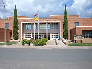
Otero County courthouse in Alamogordo
|
||
|
||

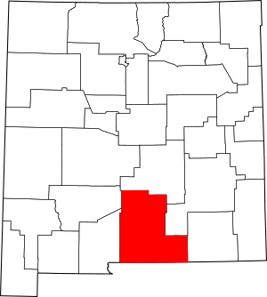
Location within the U.S. state of New Mexico
|
||
 New Mexico's location within the U.S. |
||
| Country | ||
| State | ||
| Founded | January 30, 1899 | |
| Named for | Miguel Antonio Otero | |
| Seat | Alamogordo | |
| Largest city | Alamogordo | |
| Area | ||
| • Total | 6,628 sq mi (17,170 km2) | |
| • Land | 6,613 sq mi (17,130 km2) | |
| • Water | 14 sq mi (40 km2) 0.2%% | |
| Population
(2020)
|
||
| • Total | 67,839 | |
| • Density | 10.2352/sq mi (3.9518/km2) | |
| Time zone | UTC−7 (Mountain) | |
| • Summer (DST) | UTC−6 (MDT) | |
| Congressional district | 2nd | |
Otero County (which is Condado de Otero in Spanish) is a county located in the U.S. state of New Mexico. A county is like a smaller region within a state. In 2020, about 67,839 people lived here. The main town and county seat is Alamogordo.
Otero County is on the southern border of New Mexico, right next to Texas. It was named after Miguel Antonio Otero, who was the governor of the New Mexico Territory when the county was created. The area around Alamogordo is also known as the Alamogordo Micropolitan Statistical Area.
Contents
History of Otero County
Otero County has an interesting past. A big part of its western area was given to the United States Army before World War II. This land later became part of the White Sands Missile Range, a very important military testing site. Even with this change, the county grew a lot, with its population more than doubling in the 1950s.
In 2022, the county commissioners, who are local officials, got a lot of attention. They initially refused to approve the results of the local primary election. This caused a bit of a problem, and the New Mexico Secretary of State had to take legal action. However, after a few days, two of the three commissioners agreed to certify the election results, and the issue was resolved.
Geography and Nature
Otero County is a very large area. According to the U.S. Census Bureau, the county covers about 6,628 square miles. Most of this is land (6,613 square miles), with a small amount of water (14 square miles). This makes Otero County the third-largest county in New Mexico by size.
Neighboring Counties
Otero County shares its borders with several other counties:
- Doña Ana County – to the west
- Sierra County – to the northwest
- Lincoln County – to the north
- Chaves County – to the east
- Eddy County – also to the east
- Culberson County, Texas – to the southeast
- Hudspeth County, Texas – to the south
- El Paso County, Texas – to the southwest
Special Protected Areas
Otero County is home to parts of some important natural and protected areas:
- Lincoln National Forest: A large forest where you can find many trees and wildlife.
- White Sands National Monument: A unique place known for its stunning white gypsum sand dunes.
People of Otero County
The number of people living in Otero County has changed a lot over the years. Here's how the population has grown:
| Historical population | |||
|---|---|---|---|
| Census | Pop. | %± | |
| 1900 | 4,791 | — | |
| 1910 | 7,069 | 47.5% | |
| 1920 | 7,902 | 11.8% | |
| 1930 | 9,779 | 23.8% | |
| 1940 | 10,522 | 7.6% | |
| 1950 | 14,909 | 41.7% | |
| 1960 | 36,976 | 148.0% | |
| 1970 | 41,097 | 11.1% | |
| 1980 | 44,665 | 8.7% | |
| 1990 | 51,928 | 16.3% | |
| 2000 | 62,298 | 20.0% | |
| 2010 | 63,797 | 2.4% | |
| 2020 | 67,839 | 6.3% | |
| U.S. Decennial Census | |||
In 2010, there were about 63,797 people living in the county. The average age of people in Otero County was around 36.5 years old. Many different cultures and backgrounds make up the population, including people of Hispanic or Latino origin, as well as those with German, English, and Irish ancestry.
Education in Otero County
Otero County has several school districts that serve its communities:
- Alamogordo Public Schools
- Cloudcroft Municipal Schools
- Gadsden Independent Schools
- Tularosa Municipal Schools
Interestingly, even though a part of the county is in the Alamogordo school district, some students there go to school in Dell City, Texas. This is because Dell City is much closer (about 20 miles) than Alamogordo (about 100 miles) for those students.
There are also special schools:
- Mescalero Apache Schools: These schools are connected with the Bureau of Indian Education.
- New Mexico School for the Blind and Visually Impaired: A state-operated school for students with visual impairments.
For higher education, students can attend New Mexico State University Alamogordo. The county also has the Alamogordo Public Library for everyone to enjoy books and learning.
Communities in Otero County
Otero County has several towns and villages:
City
- Alamogordo (This is the county seat, meaning it's the main administrative town.)
Villages
Other Communities
There are also many smaller communities, some of which are called Census-designated places (CDPs), which are areas identified for census purposes but are not officially incorporated towns or cities:
- Bent
- Boles Acres
- Chaparral
- High Rolls
- Holloman AFB
- La Luz
- Mayhill
- Mescalero
- Orogrande
- Piñon
- Sacramento
- Timberon
- Twin Forks
- Weed
- Hortonville
- Mountain Park
- Newman
- Sunspot
- Three Rivers
Other Interesting Places
- Mescalero Apache Indian Reservation: Home to the Mescalero Apache Tribe.
- National Solar Observatory: A place where scientists study the sun.
- Otero County Prison Facility: A correctional facility.
- White Sands National Park: A beautiful national park with unique white sand dunes.
- White Sands Ranch: A private land area.
See also
 In Spanish: Condado de Otero (Nuevo México) para niños
 | Laphonza Butler |
 | Daisy Bates |
 | Elizabeth Piper Ensley |


