
Chaves County, New Mexico facts for kids
Quick facts for kids
Chaves County
|
||
|---|---|---|

Chaves County Courthouse in Roswell
|
||
|
||

Location within the U.S. state of New Mexico
|
||
 New Mexico's location within the U.S. |
||
| Country | ||
| State | ||
| Founded | February 25, 1889 | |
| Named for | José Francisco Chaves | |
| Seat | Roswell | |
| Largest city | Roswell | |
| Area | ||
| • Total | 6,075 sq mi (15,730 km2) | |
| • Land | 6,065 sq mi (15,710 km2) | |
| • Water | 9.8 sq mi (25 km2) 0.2%% | |
| Population
(2020)
|
||
| • Total | 65,157 | |
| • Density | 11/sq mi (4/km2) | |
| Time zone | UTC−7 (Mountain) | |
| • Summer (DST) | UTC−6 (MDT) | |
| Congressional districts | 1st, 2nd, 3rd | |
Chaves County is a place in New Mexico, USA. In 2020, about 65,157 people lived there. Its main city, called the county capital, is Roswell.
The county is named after Colonel Jose Francisco Chaves. He was a military leader during the Civil War. The county was started on February 25, 1889. It was made from part of Lincoln County.
Chaves County is part of the Roswell, New Mexico area.
Contents
Chaves County Geography
Chaves County is in New Mexico. It is a very large county. It covers about 6,075 square miles. Most of this area is land. Only a small part is water.
It is the fourth largest county in New Mexico.
Neighboring Counties
Chaves County shares borders with several other counties:
- De Baca County is to the north.
- Roosevelt County is to the northeast.
- Lea County is to the east.
- Eddy County is to the south.
- Otero County is to the southwest.
- Lincoln County is to the west.
Protected Natural Areas
Some special natural places are in or near Chaves County:
- Bitter Lake National Wildlife Refuge is a home for many animals.
- Part of Lincoln National Forest is also here.
People of Chaves County
| Historical population | |||
|---|---|---|---|
| Census | Pop. | %± | |
| 1900 | 4,773 | — | |
| 1910 | 16,850 | 253.0% | |
| 1920 | 12,075 | −28.3% | |
| 1930 | 19,549 | 61.9% | |
| 1940 | 23,980 | 22.7% | |
| 1950 | 40,605 | 69.3% | |
| 1960 | 57,649 | 42.0% | |
| 1970 | 43,335 | −24.8% | |
| 1980 | 51,103 | 17.9% | |
| 1990 | 57,849 | 13.2% | |
| 2000 | 61,382 | 6.1% | |
| 2010 | 65,645 | 6.9% | |
| 2020 | 65,157 | −0.7% | |
| U.S. Decennial Census 1790-1960 1900-1990 1990-2000 2010 |
|||
The population of Chaves County has changed over the years. In 2010, there were about 65,645 people living here. There were about 23,691 homes.
Many different groups of people live in Chaves County. Most people were white. Some were Black or African American. Others were American Indian or Asian. Many people were also of Hispanic or Latino background.
The average age of people in the county was about 34.7 years old. Many homes had children living in them.
Cities and Towns
Chaves County has several communities.
Main City
- Roswell is the county's main city. It is also the county capital.
Towns
Other Communities
- Midway is a census-designated place.
- Some smaller, unincorporated communities include:
- Dunken
- Elk
- Elkins
- Greenfield
- Mesa
Education in Chaves County
Students in Chaves County attend different school districts:
- Artesia Public Schools
- Dexter Consolidated Schools
- Elida Municipal Schools
- Hagerman Municipal Schools
- Lake Arthur Municipal Schools
- Roswell Independent Schools
- Tatum Municipal Schools
Notable People
- Jacqueline Wonsetler (1918–1974) was an American meteorologist. She studied weather.
Images for kids
-
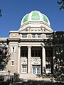
The Chaves County Courthouse in Roswell.
See also
 In Spanish: Condado de Chaves para niños
