Lea County, New Mexico facts for kids
Quick facts for kids
Lea County
|
|
|---|---|

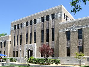
Lea County Courthouse in Lovington
|
|

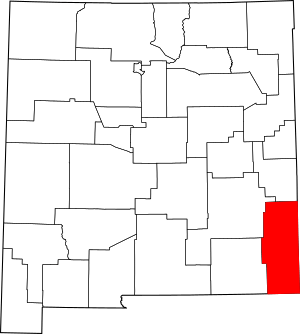
Location within the U.S. state of New Mexico
|
|
 New Mexico's location within the U.S. |
|
| Country | |
| State | |
| Founded | March 17, 1917 |
| Seat | Lovington |
| Largest city | Hobbs |
| Area | |
| • Total | 4,394 sq mi (11,380 km2) |
| • Land | 4,391 sq mi (11,370 km2) |
| • Water | 3.3 sq mi (9 km2) 0.07%% |
| Population
(2020)
|
|
| • Total | 74,455 |
| • Density | 16.9447/sq mi (6.5424/km2) |
| Time zone | UTC−7 (Mountain) |
| • Summer (DST) | UTC−6 (MDT) |
| Congressional district | 2nd |
Lea County is a county in New Mexico, a state in the United States. In 2020, about 74,455 people lived here.
Its main town, called the county seat, is Lovington. The county is located near the Texas state line. The area around Hobbs, New Mexico, is considered a small metropolitan area within Lea County.
Contents
Exploring Lea County's Geography and Location
Lea County is in the southeast part of New Mexico. It shares borders with Texas to its south and east. The county covers a total area of about 4,394 square miles (11,380 square kilometers). Most of this area, about 4,391 square miles (11,373 square kilometers), is land. Only a small part, about 3.3 square miles (8.5 square kilometers), is covered by water.
The Permian Basin: An Energy Hotspot
Underneath Lea County is a huge area called the Permian Basin. This basin is about 250 miles (400 km) wide and 350 miles (560 km) long. It is a very important source of oil and natural gas.
The basin produces a lot of crude oil every day. Experts expected this amount to double in 2019. The rock layers that hold this oil are very deep, from 3,000 to 15,000 feet (900 to 4,500 meters) below the ground.
Neighboring Counties Around Lea County
Lea County shares its borders with several other counties. These include:
- Roosevelt County – to the north
- Chaves County – to the northwest
- Eddy County – to the west
- Loving County, Texas – to the south
- Winkler County, Texas – to the southeast
- Andrews County, Texas – to the east
- Gaines County, Texas – to the east
- Yoakum County, Texas – to the east
- Cochran County, Texas – to the northeast
People and Population in Lea County
| Historical population | |||
|---|---|---|---|
| Census | Pop. | %± | |
| 1920 | 3,545 | — | |
| 1930 | 6,144 | 73.3% | |
| 1940 | 21,154 | 244.3% | |
| 1950 | 30,717 | 45.2% | |
| 1960 | 53,429 | 73.9% | |
| 1970 | 49,554 | −7.3% | |
| 1980 | 55,993 | 13.0% | |
| 1990 | 55,765 | −0.4% | |
| 2000 | 55,511 | −0.5% | |
| 2010 | 64,727 | 16.6% | |
| 2020 | 74,455 | 15.0% | |
| U.S. Decennial Census 1790-1960 1900-1990 1990-2000 2010 |
|||
Understanding the 2010 Census Data
In 2010, about 64,727 people lived in Lea County. There were 22,236 households, which are groups of people living together. The population density was about 14.7 people per square mile.
Most people in the county were White (75.0%). Other groups included African American (4.1%), Native American (1.2%), and Asian (0.5%). About 51.1% of the population identified as Hispanic or Latino.
Many households (41.9%) had children under 18 living with them. The average household had 2.82 people. The average age of people in the county was 31.9 years old.
The average income for a household was $43,910 per year. For families, the average income was $48,980. About 17.7% of all people in the county were living below the poverty line, meaning they faced financial challenges. This included 23.5% of those under 18.
Getting Around: Transportation in Lea County
Lea County has several public airports. These airports help people travel by air and support local businesses.
Airports in Lea County
- Lea County Regional Airport (HOB) – located in Hobbs
- Lea County-Jal Airport (E26) – located in Jal
- Lea County-Zip Franklin Memorial Airport (E06) – located in Lovington
- Tatum Airport (18T) – located in Tatum
Cities and Towns in Lea County
Lea County is home to several communities, from larger cities to smaller towns and villages.
Cities in Lea County
Town in Lea County
Census-Designated Places (CDPs)
These are areas identified by the U.S. Census Bureau for statistical purposes.
Other Unincorporated Communities
These are smaller communities that are not officially part of a city or town.
- Bennett
- Caprock
- Crossroads
- Knowles
- Maljamar
- McDonald
Learning in Lea County: School Districts
Lea County has several school districts. These districts provide education for students living in different parts of the county.
- Eunice Municipal Schools
- Hobbs Municipal Schools
- Jal Public Schools
- Lovington Public Schools
- Tatum Municipal Schools
Famous People from Lea County
Some notable individuals have connections to Lea County.
- Roy Cooper: A well-known rodeo cowboy.
- Kathy Whitworth: A professional golfer.
- Brian Urlacher: A famous football linebacker who played for the Chicago Bears from 2000 to 2012.
See also
 In Spanish: Condado de Lea para niños
 | Laphonza Butler |
 | Daisy Bates |
 | Elizabeth Piper Ensley |

