
Hatch, New Mexico facts for kids
Quick facts for kids
Hatch, New Mexico
|
|
|---|---|
|
Village
|
|

Hatch Municipal Building, June 2009
|
|

Location within Doña Ana County and New Mexico
|
|
| Country | United States |
| State | New Mexico |
| County | Doña Ana |
| Area | |
| • Total | 3.06 sq mi (7.94 km2) |
| • Land | 3.00 sq mi (7.78 km2) |
| • Water | 0.06 sq mi (0.16 km2) |
| Elevation | 4,062 ft (1,238 m) |
| Population
(2020)
|
|
| • Total | 1,539 |
| • Density | 512.15/sq mi (197.75/km2) |
| Time zone | UTC-7 (Mountain (MST)) |
| • Summer (DST) | UTC-6 (MDT) |
| ZIP code |
87937
|
| Area code | Area code 575 |
| FIPS code | 35-31820 |
| GNIS ID | 2413557 |
Hatch is a village in Doña Ana County, New Mexico, United States. The population was 1,539 in 2020. Nearby smaller towns like Salem, Arrey, Derry, and Rincon are also growing.
Hatch is famous as the "Chile Capital of the World." It grows many types of peppers, especially the New Mexico chile, which is a key part of New Mexican cuisine. This chile is even one of New Mexico's state vegetables!
Contents
History of Hatch
Hatch was first settled in 1851 and called Santa Barbara. However, Apache raids made farmers leave. In 1853, Fort Thorn was built nearby, and people returned.
The fort closed in 1859, and the town was empty again by 1860. It was settled once more in 1875. At that time, it was renamed "Hatch" after Edward Hatch. He was a military leader in the District of New Mexico.
Where is Hatch Located?
Hatch is located in New Mexico, a state in the southwestern United States. The village covers about 3.1 square miles (7.9 square kilometers) of land.
It is just off Interstate 25. Hatch is about 40 miles (64 km) northwest of Las Cruces. It is also about 80 miles (129 km) northwest of El Paso, Texas.
Population of Hatch
Hatch is part of the Las Cruces area. In 2000, there were 1,673 people living in the village. There were 538 households and 402 families.
About 43.7% of households had children under 18. Many families were married couples living together. The average household had about 3 people.
The population was quite young. About 35.7% of people were under 18. The average age was 30 years old.
| Historical population | |||
|---|---|---|---|
| Census | Pop. | %± | |
| 1930 | 364 | — | |
| 1940 | 822 | 125.8% | |
| 1950 | 1,064 | 29.4% | |
| 1960 | 888 | −16.5% | |
| 1970 | 867 | −2.4% | |
| 1980 | 1,028 | 18.6% | |
| 1990 | 1,136 | 10.5% | |
| 2000 | 1,673 | 47.3% | |
| 2010 | 1,648 | −1.5% | |
| 2020 | 1,539 | −6.6% | |
| U.S. Decennial Census | |||
Hatch's Economy and Chile Festival
The Hatch Chile Festival is a big event held every Labor Day. This festival brings people from all over the world to Hatch. It is known as the "chile capital of the world." The small town has hosted up to 30,000 people for this event.
This farming community is famous for growing excellent chiles. By 2012, Hatch chiles were sold in many major cities across the US. Farmers also grow other crops like onions, cotton, and corn.
Farms get water from wells that pump groundwater. They also use irrigation ditches that take water from the Rio Grande. Two lakes, Caballo and Elephant Butte Reservoir, also provide water. These lakes are about 20 miles (32 km) north of Hatch.
Hatch is about 40 miles (64 km) northwest of Las Cruces, New Mexico. It is also 34 miles (55 km) south of Spaceport America. This is a new spaceport built by the New Mexico Spaceport Authority (NMSA). In 2012, the NMSA announced plans to build a spaceport visitor center in Hatch.
Education in Hatch
The local school district is called Hatch Valley Public Schools.
Getting Around Hatch
Hatch has public transportation through the South Central Regional Transit District. This service connects Hatch to Las Cruces in the south. It also goes to Truth or Consequences in the north.
The Southwestern Railroad also has tracks that pass through Hatch.
Images for kids
-
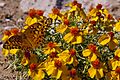
Butterfly on desert zinnia, BLM Las Uvas Mountains Wilderness Study Area, 4 miles south of Hatch
-
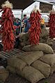
Ristras and sacks of chiles at the annual Hatch Chile Festival, August 2008


See also
 In Spanish: Hatch (Nuevo México) para niños
