
Elephant Butte Reservoir facts for kids
Quick facts for kids Elephant Butte Reservoir |
|
|---|---|

Elephant Butte Reservoir and Dam
|
|

Elephant Butte Reservoir
Location in New Mexico

Elephant Butte Reservoir
Location in the United States
|
|
| Location | Sierra County, New Mexico |
| Coordinates | 33°14′19.43″N 107°10′26.23″W / 33.2387306°N 107.1739528°W |
| Lake type | Hydroelectric reservoir |
| Primary inflows | Rio Grande |
| Primary outflows | Rio Grande |
| Basin countries | United States |
| Surface area | 36,500 acres (14,800 ha) |
| Water volume | 2,065,010 acre⋅ft (2.54715 km3) |
| Surface elevation | 4,414 ft (1,345 m) |
Elephant Butte Reservoir is a huge man-made lake in New Mexico, United States. It was created on the Rio Grande river, about 5 miles (8.0 km) north of Truth or Consequences. This reservoir is the largest lake in New Mexico. It is measured by its total surface area and how much water it can hold. It is also the 84th largest man-made lake in the entire United States.
Elephant Butte Reservoir is part of Elephant Butte Lake State Park. This park is the biggest state park in New Mexico. You might even spot pelicans here, as it's the only place in New Mexico where they are commonly found. The reservoir was built as part of the Rio Grande Project. This project helps provide power and water for farming in New Mexico and Texas.
Contents
What is Elephant Butte Reservoir?
The reservoir is a large body of water held back by the Elephant Butte Dam. It started filling with water between 1915 and 1916. When it was completely full, it was the largest man-made lake in the world. The reservoir can hold over 2,065,010 acre-feet (2.54715×10⁹ m3) of water. This water comes from an area of 28,900 square miles (74,850 km²). It provides water to irrigate, or water, 178,000 acres (720 km²) of farmland.
Fun Activities at the Reservoir
Many people enjoy visiting Elephant Butte Reservoir. Fishing is a very popular activity here. The lake is home to many kinds of fish, including:
- Striped bass
- White bass
- Largemouth bass
- Crappie
- Walleye
- Catfish
Why is it Called Elephant Butte?
The reservoir, the dam, and the area around them are named after a special rock formation. This formation is called "Elephant Butte". It is a volcanic core, similar to Devils Tower in Wyoming. When the water levels are high, this butte becomes an island in the lake. People say it looks like an elephant lying on its side.
Building the Elephant Butte Dam
The Elephant Butte Dam was a very important project. It was built between 1911 and 1916. The reservoir began filling in 1915. Building such a large concrete dam was a huge engineering achievement for its time. The dam is a main part of the Elephant Butte National Register Historic District. You can visit a center at the state park to learn more about how the dam was built.
How the Dam Changed the Area
When the dam was built, it was the second-largest irrigation dam ever made. Only the Aswan Dam in Egypt, built in 1970, was bigger. The reservoir itself was the largest man-made lake on Earth for a while.
A large community grew around the construction site. This included two camps for workers, railways, and systems to move materials. American and Mexican workers lived in these camps. One camp ended up under the reservoir when it filled. Many old towns and farms were also covered by the water. Over 2,000 people had to move from their homes.
Water Levels Over Time
When the reservoir first filled in 1915, not as much water was used for farming. This allowed the lake to stay quite full. In May 1942, the lake reached its highest level ever. This high water left white mineral stains on the hillsides around the lake.
By 1950, more water was being used for farming. Also, a long dry period in the upper river basin caused water levels to drop. The lowest water level was recorded on August 6, 1954. The lake was very full again from 1985 to 1988. Other high water times were in 1994 and 1995. Many photos of a full lake are from these years. Since then, there has been a long dry period. Water levels have not recovered to their previous highs.
Discoveries at the Lake
The old building where the Bureau of Reclamation worked is still standing. It is now a bed and breakfast. This building and others from that time are listed in the National Register of Historic Places. When the lake's water level drops a lot, you can see the ruins of an old machine shop and power plant. This concrete building was once thought to be a hospital for the dam workers. Plans are being made to turn these ruins into a place for scuba diving when the water levels are high again.
In 2014, a group of people found something amazing. They discovered the head and tusks of a 3.2 million-year-old stegomastodon. This animal was a relative of modern elephants. The skull was in excellent condition. It is one of the most complete stegomastodon finds in the area. You can see the skull on display at the New Mexico Museum of Natural History and Science.
Images for kids
-

Panoramic view of Elephant Butte Reservoir in 2005
-
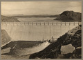
The dam at Elephant Butte Reservoir in 1916, before the 1944 highstand.
-
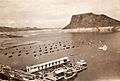
Elephant Butte Reservoir in 1946 after the highstand. Note the mineral stains on the hillsides created just two years prior.

