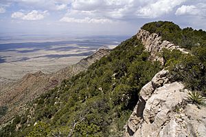
Oscura Mountains facts for kids
The Oscura Mountains are a long line of mountains in New Mexico, USA. The Spanish people originally called them Sierra Oscura, which means "Dark Mountains." These mountains run from north to south. They are located between the Jornada del Muerto desert to the west and the Tularosa Valley to the east.
About the Oscura Mountains
The Oscura Mountains are found in two counties in New Mexico: Socorro County and Lincoln County, New Mexico. They are a significant natural feature in this part of the state.
Oscura Peak: The Tallest Point
The highest point in the Oscura Mountains is a peak called Oscura Peak. It stands very tall at 8,625 feet (or 2,629 meters) above sea level. This makes it a prominent landmark in the area.
The southern end of the mountain range is located at 33°30′30″N 106°18′45″W / 33.50833°N 106.31250°W. The northern end is near North Oscura Peak, at 33°49′15″N 106°22′20″W / 33.82083°N 106.37222°W. These coordinates help people find the exact start and end points of the mountains.
Mountains Nearby
The Oscura Mountains are surrounded by other interesting landforms. To their northwest, you'll find the Little Burro Mountains. A space called Oscura Gap separates these two mountain ranges.
Beyond the Little Burro Mountains, to the southwest, are the San Andres Mountains. Mockingbird Gap is the area that divides the Little Burro Mountains from the San Andres Mountains.
The northern edge of the Oscura Range is marked by Wash Hale Canyon. To the northeast, you can see the Chupadera Mesa, which is a flat-topped hill. The Tularosa Valley forms the eastern border of the Oscura Mountains.
 | Dorothy Vaughan |
 | Charles Henry Turner |
 | Hildrus Poindexter |
 | Henry Cecil McBay |


