Jornada del Muerto facts for kids
The name Jornada del Muerto comes from Spanish. It means "Journey of the Dead Man" or "Route of the Dead Man." Spanish explorers gave this name to a very dry, flat desert basin. This basin was a tough, 100-mile (160 km) stretch of a route. It went from Las Cruces to Socorro in what is now New Mexico.
This route was part of the Camino Real de Tierra Adentro. This important trail connected central New Spain (now Mexico) to its northern lands. These lands were around the upper Rio Grande valley.
Contents
Exploring the Jornada del Muerto Desert
The Jornada del Muerto desert is a wide, flat area. It stretches about 100 miles (160 km) from north to south. This desert is a Chihuahuan Desert ecoregion. It has a dry, shrubby habitat.
The desert lies between mountain ranges. The Oscura Mountains and San Andres Mountains are to the east. The Fra Cristóbal Range and Caballo Mountains are to the west. The western mountains block easy access to the Rio Grande. This river was the most reliable water source nearby.
Today, the Jornada del Muerto Desert is mostly empty. It has not been developed much. On its eastern side, there is the Jornada Basin LTER station. Scientists use this station to study desert plants and animals. They also learn about managing desert land.
Volcanoes and Lava Fields
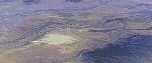
At the northern end of the desert, you'll find the Jornada del Muerto volcano. There is also a large lava field called a malpaís. The Jornada del Muerto Volcano is a shield volcano. It erupted about 760,000 years ago. It reached a height of 5,136 feet (1,565 m).
The volcano's lava created a huge lava field. This field is about 10 by 15 miles (16 by 24 km) wide. It covers over 170 square miles (440 km2). The lava was thick and slow-moving. It left a very rough surface. This made travel across it extremely difficult.
The History of the Journey
The name "Journey of the Dead Man" likely came from the lack of resources. There was no water, no grass for animals, and no firewood. Early Spanish travelers found it very hard to cross this area. They often traveled on foot with carts pulled by oxen. Even though the land was flat, crossing the Jornada del Muerto took several days to a week.
After crossing this difficult desert, the Spanish explorers met the Puebloan peoples. These people lived in walled villages. They had good farming skills and were peaceful. In 1598, the Spanish reached the first pueblo after the Jornada. They named it Socorro, which means 'help' in Spanish.
In 1680, the Pueblo Revolt forced Spanish settlers to flee south. They traveled along the Jornada del Muerto. Many Native Americans from the Isleta and Socorro Pueblos also joined them. More than 2,000 people left Socorro, but fewer than 1,200 survived the journey. The survivors settled near the Rio Grande, around what is now El Paso, Texas. In 1692, Diego de Vargas led new settlers north across the Jornada del Muerto. They went to resettle northern New Mexico.
Later, people on horseback could cross the Jornada faster. Bishop Tamarón described his journey in 1760. He said they prepared by getting water from the Rio Grande. They filled barrels for people and let horses drink. They traveled quickly, stopping only to change horses. This way, they crossed the 30-league (about 90-mile) stage in a couple of days.
From the 1860s to the 1920s, some families tried to ranch in the Jornada del Muerto. They dug wells to get water for their cattle. The first well was at Aleman. This was one of the last homesteads to be left in the late 1900s.
The Historic Trail Route
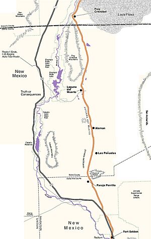
The Jornada del Muerto trail was a key part of the Camino Real. When traveling north, it left the Rio Grande at Paraje de Robledo. This place was just north of Las Cruces, New Mexico. The trail went north through a gap between the Selden Hills and Doña Ana Mountains. Then it reached the flat Jornada plain. The last chance to get water was at the Paraje de San Diego. This spot overlooked the Rio Grande, a short distance from Robledo.
The next place with water was at Paraje del Perrillo. This was near Point of Rocks. This point is the southernmost part of the Jornada basin. The trail continued north through dry, scrubby land. It passed another small, temporary watering spot called La Cruz de Alemán. This place was named after a German merchant who died of thirst there. Today, the Bar Cross Ranch buildings stand on the site of the original settlement.
Further north, the trail crossed several small, temporary lake beds. These were called the Jornada Lakes. The trail then went to Engle Lake, also known as the Laguna del Muerto. If Laguna del Muerto was dry, travelers could find water at Ojo del Muerto. This was a spring in Cañon del Muerto. It was in the southern Fra Cristóbal Range, near where Fort McRae was later built.
At the northern end of the basin, the trail narrowed. It went through the Lava Gate. This was between the Fra Cristóbal Range and the Jornada del Muerto Volcano lava fields. The part of the trail without water ended at Paraje de Fray Cristóbal on the Rio Grande.
The trail then continued north along the river. It crossed a small part of the Jornada del Muerto Volcano lava fields. These fields originally stretched across the Rio Grande. This lava field was very rough, making travel difficult. This part of the trail reached the Paraje del Contadero. It then passed around the Mesa del Contadero. Finally, it reached a crossing point on the Rio Grande called Val Verde. A large Spanish ranch was built there in the 1820s. But it was soon abandoned due to attacks.
In 1846, Major Philip St. George Cooke and the Mormon Battalion created a wagon road. This road went along the west bank of the Rio Grande. It then turned west to become Cooke's Wagon Road. After the Mexican–American War and the California Gold Rush, many people used this road to travel to California.
After the United States took over New Mexico, the U.S. Army began protecting settlements. They also protected travel on the lower Rio Grande. Fort Conrad was built in 1851. It was replaced by Fort Craig in 1854. Fort Thorn was built in 1853. These forts offered protection on the Jornada road. They also protected the Fort Craig - Fort Thorn Wagon Road. This road supplied the forts. This Army protection led to new settlements along the lower Rio Grande. These included Santa Barbara in 1853 and San Ygnacio de Alamosa in 1859.
The First Atomic Test
On July 16, 1945, the first atomic weapon was exploded. This happened at the Trinity nuclear test site. It was about 40 miles (64 km) northeast of the Jornada del Muerto. Less than a month later, the "Little Boy" nuclear bomb was dropped on Hiroshima, Japan.
Jornada del Muerto in Arts
- "Jornada del Muerto" is a song on Linkin Park's album A Thousand Suns. This album is about nuclear warfare.
- "Jornada del Muerto" is also a song on Nadja's album Excision.
- The novel Mount Dragon by Douglas Preston and Lincoln Child takes place in a testing facility in the Jornada del Muerto.
- A part of the novel Flashman and the Redskins by George MacDonald Fraser happens in the Jornada del Muerto.
- A part of the novel Dead Man's Walk by Larry McMurtry is set in this region.
- The 1951 film Only the Valiant, starring Gregory Peck, is set in the area.
- The song "Leaving El Paso" by Tom Russell mentions the Spanish journey out of the Rio Grande Valley.
See also
 In Spanish: Jornada del Muerto para niños
 | Dorothy Vaughan |
 | Charles Henry Turner |
 | Hildrus Poindexter |
 | Henry Cecil McBay |


