
Carrizozo Malpais facts for kids
The Carrizozo Malpais is a huge lava flow in New Mexico. It's found on the west side of Carrizozo. This amazing rock formation stretches across the northern part of the Tularosa Basin. It lies between the Sierra Blanca mountains and the Oscura Mountains.
Contents
Carrizozo Malpais: A River of Rock

The Carrizozo Malpais is a very large area covered by hardened lava. It looks like a long, dark river of rock. This lava came from a place called Little Black Peak. This peak is about 10 miles (16 km) north of Carrizozo.
The lava flowed for a long distance. It traveled about 40 miles (64 km) to the south. It moved in two main streams. This created the vast Malpais we see today.
How Old is This Lava?
Scientists have studied the Carrizozo Malpais. They wanted to know how old it is. At first, they thought it was about 1,000 to 1,500 years old.
But newer methods helped them find a more exact age. Using special dating techniques, they learned the eruption happened about 5,200 years ago. This makes the lava flow quite ancient!
The southern end of the lava flow is interesting. It's about 12 miles (19 km) north of the famous White Sands National Park. The White Sands are known for their beautiful gypsum dunes. A group called the Carrizozo Woman's Club helped protect this special area.
Exploring the Valley of Fires
You can visit the Carrizozo Malpais! The Valley of Fires Recreation Area offers easy access. It's on the eastern edge of the lava flow. This area is about 3 miles (5 km) west of Carrizozo. You can reach it from U.S. Route 380.
The highway has several spots where you can stop. These are called scenic overlooks. From these spots, you can see the vast lava fields. If you go to higher places east of the highway, you can see the entire flow.
An important historical site is also nearby. The Trinity site is about 20 miles (32 km) northwest. This was the location of the first atomic bomb test.
Images for kids
-
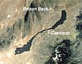
The location of Carrizozo.
-
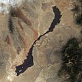
Satellite image of Carrizozo.
-
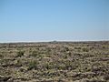
An overview of the lava flows (Little Black Peak in distance).
-
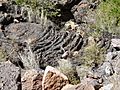
A close-up view of the lava flows. Notice the pahoehoe (Hawaiian for "ropey") lava flow structure.
-
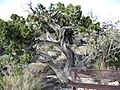
A juniper tree grows out of the Carrizozo Malpaís.


