
Carrizozo, New Mexico facts for kids
Quick facts for kids
Carrizozo, New Mexico
|
|
|---|---|

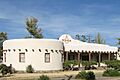
Downtown Carrizozo
|
|
| Nickname(s):
'Zozo
|
|

Location of Carrizozo, New Mexico
|
|

Carrizozo, New Mexico
Location in the United States
|
|
| Country | United States |
| State | New Mexico |
| County | Lincoln |
| Area | |
| • Total | 8.36 sq mi (21.66 km2) |
| • Land | 8.36 sq mi (21.66 km2) |
| • Water | 0.00 sq mi (0.00 km2) |
| Elevation | 5,545 ft (1,690 m) |
| Population
(2020)
|
|
| • Total | 972 |
| • Density | 116.25/sq mi (44.88/km2) |
| Time zone | UTC−7 (Mountain (MST)) |
| • Summer (DST) | UTC−6 (MDT) |
| ZIP Code |
88301
|
| Area code(s) | 575 |
| FIPS code | 35-12500 |
| GNIS feature ID | 2413174 |
Carrizozo is a town in Lincoln County, New Mexico, United States. It is the main town, or county seat, of Lincoln County. About 972 people lived there in 2020. The town started in 1899 because of the railroad. The railroad helped it grow a lot early on. But as trains became less important, the town's population slowly got smaller. Carrizozo is found where two main roads meet: U.S. Routes 54 and 380.
Contents
What's in a Name?
The name Carrizozo comes from a Spanish word, Carrizo. This word means "reed grass." Lots of this grass grew in the area. It was great food for ranch cattle. The extra "zo" at the end of the name means there was a huge amount of this grass. Today, people sometimes call the town "Zozo."
A Look Back: Carrizozo's History

Before 1899, this area was mostly just a few ranches. It was also a stop for stagecoaches. Not many people lived here permanently.
The Railroad Arrives
In 1899, Carrizozo was chosen as a stop for the El Paso and Northeastern Railway. This was a big deal! A nearby mining town called White Oaks was booming. But Carrizozo got the railroad instead. Many people moved from White Oaks to Carrizozo.
The railroad brought new businesses and more people. This made Carrizozo very important. In 1909, the county decided to move its main office from Lincoln to Carrizozo. This led to a four-year legal fight. But in the end, Carrizozo won. The town grew quickly because of the railroad and its new political role. By 1920, about 2,000 people lived there.
Famous Visitors and Nearby Events
A U.S. Senator named Albert B. Fall owned a ranch near Carrizozo. He later had to sell it because of legal issues.
A journalist named Quentin Reynolds visited Carrizozo. He wrote about it for a magazine called Collier's. He even said he wanted to go back to Carrizozo when he died. He liked hanging out at the drug store there.
Carrizozo is about 35 miles (56 km) east of the Trinity Site. This is where the first nuclear bomb was set off on July 16, 1945. People in Carrizozo felt the ground shake like an earthquake. The town was the first big settlement downwind. It received some of the dust and particles from the mushroom cloud. This caused some radioactive contamination in the area. Bonito Lake, which was a water source for Carrizozo, was also in this area.
Changes Over Time
After the 1950s, cars became more popular. This made the railroad less important for Carrizozo. The last passenger train came through in 1968. This meant fewer jobs and opportunities in the town. The population went down to about 1,200 people for many years.
Recently, Carrizozo has focused more on tourism. For a while, cherry cider made in the town was famous across the country. However, the Carrizozo Orchard has since closed.
Carrizozo's Natural Surroundings

Carrizozo is at the northern end of the Tularosa Basin. This basin stretches south to the New Mexico–Texas border. The town itself is on a flat area. This area used to be called the Corrizo flats. It has typical Chihuahuan desert plants and grasslands.
Unique Landforms Nearby
To the west of town is the Carrizozo Malpais. This is a 40-mile (64 km) long lava flow. It is about 1,500 years old. You can visit it at the Valley of Fires Recreation Area.
To the northeast is Carrizo Mountain. This peak is 9,600 feet (2,926 m) tall. It is part of the Sacramento Mountains. To the southeast are the Sierra Blanca mountain range.
Carrizozo's Weather
| Weather chart for Carrizozo, New Mexico | |||||||||||||||||||||||||||||||||||||||||||||||
|---|---|---|---|---|---|---|---|---|---|---|---|---|---|---|---|---|---|---|---|---|---|---|---|---|---|---|---|---|---|---|---|---|---|---|---|---|---|---|---|---|---|---|---|---|---|---|---|
| J | F | M | A | M | J | J | A | S | O | N | D | ||||||||||||||||||||||||||||||||||||
|
0.6
55
25
|
0.7
56
26
|
0.7
63
30
|
0.5
72
37
|
0.7
85
47
|
1.1
96
59
|
2.1
95
55
|
2.4
87
54
|
1.5
82
51
|
1.4
72
40
|
0.6
60
28
|
0.9
55
25
|
||||||||||||||||||||||||||||||||||||
| temperatures in °F precipitation totals in inches |
|||||||||||||||||||||||||||||||||||||||||||||||
|
Metric conversion
|
|||||||||||||||||||||||||||||||||||||||||||||||
Who Lives in Carrizozo?
| Historical population | |||
|---|---|---|---|
| Census | Pop. | %± | |
| 1920 | 1,301 | — | |
| 1930 | 1,171 | −10.0% | |
| 1940 | 1,457 | 24.4% | |
| 1950 | 1,389 | −4.7% | |
| 1960 | 1,546 | 11.3% | |
| 1970 | 1,123 | −27.4% | |
| 1980 | 1,222 | 8.8% | |
| 1990 | 1,075 | −12.0% | |
| 2000 | 1,036 | −3.6% | |
| 2010 | 996 | −3.9% | |
| 2020 | 972 | −2.4% | |
| U.S. Decennial Census | |||
In 2010, there were 996 people living in Carrizozo. Most people (about 78.7%) were White. About 43.6% of the people were Hispanic. More men lived in the town (54.7%) than women (45.3%). About 16% of the people were under 18 years old. About 24.5% were over 65. The rest, about 59.5%, were between 18 and 65.
Getting Around Carrizozo
Carrizozo is located where U.S. Routes 54 and 380 meet. These are important roads for travel.
Trains still carry freight (goods) through Carrizozo. This service is provided by Union Pacific.
For small planes, the town has the Carrizozo Municipal Airport.
Schools in Carrizozo
Carrizozo Municipal Schools is the local school district. It serves the students in the area.
Fun Places to Visit

- Carrizozo Women's Club: This building was built in 1920. It has a special Pueblo Revival style. It is listed on the National Register of Historic Places.
- Carrizozo Heritage Museum: This building was once a frozen food locker in the 1940s. In 2003, it became a museum about local history.
- Lincoln National Forest: This large forest is southeast of the city. You can reach it by taking U.S. Route 380 and NM 37.
- Valley of Fires Recreation Area: This area is west-northwest of the city. It is known for its lava flows. You can get there by taking U.S. Route 380.
Carrizozo in Movies and TV
Several movies have been filmed, at least partly, in Carrizozo. Some of these include:
- Wander (2020)
- Gambit (2012)
- This Must be the Place (2011)
- The Book of Eli (2010)
- Deja Vu, Hera's Odyssey (2004)
- The Outfitters (1999)
- Mad Love (1995)
Famous People from Carrizozo
- Albert B. Fall: He was the first senator from New Mexico (1912–1921).
- Rick Geary: An American cartoonist and illustrator. He has lived in Carrizozo since 2007.
- Charlie Siringo: A famous Pinkerton detective. He worked in Carrizozo from 1916 to 1917 to catch cattle thieves.
- Earl Reece Stadtman: A biochemist who was born in Carrizozo in 1919.
Images for kids
-
The Carrizozo Women's Club

See also
 In Spanish: Carrizozo para niños
