Carrizozo volcanic field facts for kids
Quick facts for kids Carrizozo Volcanic Field |
|
|---|---|
 |
|
| Highest point | |
| Elevation | 1,565 to 1,730 m (5,135 to 5,676 ft) |
| Geography | |
| Location | Lincoln County, New Mexico, United States |
| Geology | |
| Mountain type | volcanic field |
| Volcanic arc/belt | Rio Grande Rift |
| Last eruption | 3250 BCE ± 500 years |
The Carrizozo volcanic field is a special area in New Mexico, United States. It's called a monogenetic volcanic field because its volcanoes erupted only once. This field has two main lava flows: the Broken Back flow and the Carrizozo lava flow.
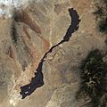
The Carrizozo lava flow is the second newest lava flow in New Mexico. Both of these flows started from groups of small volcanoes called cinder cones. The Broken Back flow is about 16 kilometres (10 mi) long. The Carrizozo flow is much bigger, stretching 68 kilometres (42 mi)! It's one of the largest lava flows in the world. This huge flow covers an area of 328 square kilometres (127 sq mi) and has a volume of 4.2 cubic kilometres (1.0 cu mi) of cooled lava.
Contents
What is a Volcanic Field?
A volcanic field is a place where many small volcanoes have erupted over time. Unlike a single, giant volcano, a volcanic field has lots of smaller vents. The Carrizozo field is a "monogenetic" type, which means each of its volcanoes erupted just once.
How Lava Flows Formed
The lava flows at Carrizozo came from cinder cones. A cinder cone is a simple, cone-shaped volcano. It forms when volcanic ash, cinders, and rocks build up around a volcanic vent. When these cones erupted, hot, melted rock (lava) flowed out and spread across the land.
The Carrizozo Malpais
The Carrizozo lava flow is also known as the Carrizozo Malpais. "Malpais" is a Spanish word that means "bad land." This name was given because the rough, rocky lava makes it hard to walk or grow things there. The lava cooled into many interesting shapes, including pahoēhoē lava, which looks like ropes.
Exploring the Carrizozo Volcanic Field
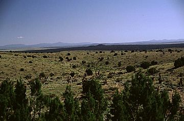
Today, the Carrizozo Volcanic Field is a unique place to visit. You can see the vast, dark lava flows and imagine what it was like when they were hot and flowing. Even though the land is rocky, some plants and animals have found ways to live there. For example, western juniper trees can grow right out of the lava rock.
Where is it Located?
The Carrizozo Volcanic Field is in Lincoln County, New Mexico. It's part of a larger area called the Rio Grande Rift, which is a big crack in the Earth's crust where the land is slowly pulling apart. This pulling apart can cause volcanic activity.
When Did it Erupt?
The last time the Carrizozo Volcanic Field erupted was around 3250 BCE (Before Common Era). That's about 5,270 years ago! While it's considered an inactive volcano now, the landscape still shows the powerful forces that shaped it long ago.
Images for kids
-
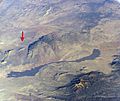
The Carrizozo Malpais is the long dark streak across the bottom half of the image. The red arrowhead marks the location of Trinity site. Sierra Blanca is visible at lower right. The low ridge toward the top of the photo is the Oscura Mountains. Credit: NASA Astronaut photograph ISS008-E-5604, taken at an altitude of 193 miles (311 km).
-
A close-up view of the lava flows, showing pahoēhoē (Hawaiian for "ropey") lava flow structure.
-
A western juniper tree grows out of the Carrizozo Malpaís.
 | Leon Lynch |
 | Milton P. Webster |
 | Ferdinand Smith |


