Guadalupe Mountains facts for kids
Quick facts for kids Guadalupe Mountains |
|
|---|---|
Guadalupe Mountains
|
|
| Highest point | |
| Peak | Guadalupe Peak |
| Elevation | 8,751 ft (2,667 m) |
| Dimensions | |
| Length | 65 mi (105 km) |
| Width | 20 mi (32 km) |
| Geography | |
| Country | |
| Geology | |
| Age of rock | Permian |
| Type of rock | Carbonate sponge reef complex |
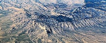
The Guadalupe Mountains (also known as Sierra de Guadalupe in Spanish) are a cool mountain range. You can find them in West Texas and southeastern New Mexico. This range is home to Guadalupe Peak, which is the highest point in Texas. It stands tall at 8,751 ft (2,667 m)!
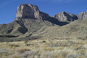
Another famous peak here is El Capitan. Both of these amazing peaks are part of the Guadalupe Mountains National Park. The mountains are surrounded by the Pecos River valley and Llano Estacado to the east and north. To the south are the Delaware Mountains, and to the west are the Sacramento Mountains.
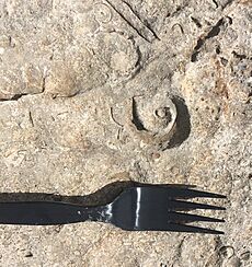
What makes these mountains super special? They hold one of the clearest examples of a prehistoric reef! This ancient reef is preserved in the rocks. These rocks contain fossils of creatures that lived in the reef during the Permian period. Scientists like paleontologists (who study fossils) love to study the geology here.
Contents
A Look Back: History of the Mountains
Archaeologists have found proof that people lived in these mountains over 10,000 years ago. These early humans were hunter-gatherers. They hunted big animals and collected plants for food. Things like old tools, baskets, pottery, and rock art show us how they lived.
Early European Visitors and Native Tribes
The first Europeans, who were Spaniards, arrived in the 1500s. But they didn't try to settle in the Guadalupe Mountains much. The Spanish brought horses to the area. Soon, local tribes like the Apaches found horses very useful for hunting and moving around.
The Mescalero Apaches were a nomadic tribe. This means they moved from place to place. They followed game and harvested agave plants for food and fiber. The word "Mescalero" actually means "mescal-maker" in Spanish. You can still find old agave-roasting pits from their culture in the park today.
The Mescalero Apaches lived in these mountains until the mid-1800s. But then, an American transportation route was built after the American Civil War. Many people moving west crossed through this area in the 1840s and 1850s.
The Butterfield Overland Mail and Buffalo Soldiers
In 1858, a place called Pinery station was built near Pine Springs. This was for the Butterfield Overland Mail, a stagecoach service. The mail route went over Guadalupe Pass, which is 5,534 ft (1,687 m) high.
Soldiers known as the Buffalo Soldiers were sent to the area. Their job was to stop raids by Native Americans on settlements and mail routes. In the winter of 1869, Lt. H.B. Cushing led his troops into the mountains. They destroyed two Mescalero Apache camps. Eventually, the Mescalero Apache were moved to US Indian reservations.
Ranchers and the National Park
Felix McKittrick was one of the first European settlers in the Guadalupe Mountains. He raised cattle in the 1870s. McKittrick Canyon is believed to be named after him.
The Frijole Ranch was the first permanent ranch house. It was built in 1876 by the Rader brothers. This ranch house was important. It served as a community center and post office from 1916 to 1942. Today, the Frijole Ranch House is a museum.
In 1921, Wallace Pratt, a geologist, was amazed by McKittrick Canyon's beauty. He bought land there and built two summer homes. Pratt later donated about 6,000 acres (24 km2) of McKittrick Canyon. This land became part of Guadalupe Mountains National Park. In 1978, the United States Congress made 46,850 acres (190 km2) of the Texas side a special wilderness area. This area is protected by the National Park Service.
Exploring the Geography
The Guadalupe Mountains reach their highest point at Guadalupe Peak. This is the tallest spot in Texas, standing at 8,751 feet (2,667 m). The range is southeast of the Sacramento Mountains. It is also east of the Brokeoff Mountains.
The mountains stretch from Guadalupe Peak in Texas into New Mexico. The northern part ends near Carlsbad, close to Carlsbad Caverns National Park. The southern tip, with El Capitan, is about 90 miles (140 km) east of El Paso. These mountains rise more than 3,000 feet (910 m) above the dry Chihuahuan Desert floor.
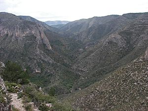
A dramatic cliff called "The Rim" marks the northwestern part of the range. This part extends far into New Mexico. The mountains are bordered by Four Mile Canyon to the north and the Pecos River valley to the east.
Most of the range is made from the ancient Capitán Reef. This reef formed at the edge of a shallow sea during the Permian period. The "Guadalupian" time period is even named after these mountains! Because the mountains are mostly limestone, there isn't much surface water in the higher areas. McKittrick Creek, in McKittrick Canyon, is the only important surface water.
Mountain Weather
The Guadalupe Mountains have hot summers. Autumns are usually calm and mild. Winters and early springs can be cool to cold. Sometimes, there are snowstorms, freezing rain, or fog. Strong winds are common from winter through spring. Late summer brings thunderstorms from monsoons. Even in summer, the nights are cool.
Geology: A Look at Ancient Rocks
The Guadalupe Mountains are made of sedimentary rocks from the Permian period. These rocks are now thousands of feet above sea level. But long ago, the sediments that formed them were laid down in the Delaware Basin. This was a shallow ocean area at the southern edge of what was then North America.
The environment was likely similar to places like the Bahamas or southern Florida today. Warm, clear water was perfect for photosynthetic organisms and the growth of carbonate reefs. When these organisms died, their calcium carbonate shells formed Limestone rock. This preserved their fossils and ancient environment.
This process created the Capitan Reef. It's one of the largest and most continuous prehistoric limestone reefs visible today. Over time, the rocks from these ancient oceans were lifted up. This created the tall mountains we see now.
Caves and Canyons
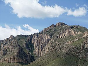
The Guadalupe Mountains have many canyons that expose these marine rocks. The continuous limestone of the Capitan Reef forms large, noticeable cliffs. These cliffs are often seen along the eastern side of the park.
Water moving through cracks in the limestone dissolves it. This creates huge cave systems, like the famous Carlsbad Caverns.
Ecology: Plants and Animals
The mountain range has three main types of ecosystems.
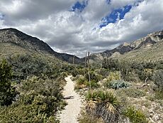
- Deserts: On the western side of the park, you'll find salt flats and creosote desert. Lower elevations on the east have grassland, pinyon pine, and juniper trees.
- Canyons: Inside canyons like McKittrick, Bear, and Pine Springs Canyon, you'll see maple, ash, chinquapin oak, and other deciduous trees. These trees can grow in the desert because springs provide water from the wetter uplands.
- Uplands: High up in areas called "the Bowl," above 7,000 ft (2,100 m), there are denser forests. Here you'll find ponderosa pine, southwestern white pine, douglas-fir, and small groups of aspen trees.
The range is also famous for its many amazing caves. Carlsbad Caverns is the most well-known. Another incredible cave is Lechuguilla Cave, discovered in 1986.
See also
 In Spanish: Sierra de Guadalupe (Texas) para niños
 | Jewel Prestage |
 | Ella Baker |
 | Fannie Lou Hamer |


