Sierra de Villuercas facts for kids
Quick facts for kids Sierra de Villuercas |
|
|---|---|
| Sierra de Guadalupe | |

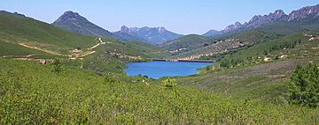
The Sierra de Villuercas and Santa Lucia Dam
|
|
| Highest point | |
| Peak | La Villuerca |
| Elevation | 1,603 m (5,259 ft) |
| Dimensions | |
| Length | 62 km (39 mi) NW/SE |
| Width | 15 km (9.3 mi) NE/SW |
| Geography | |
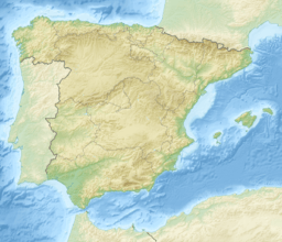
| Location | Extremadura |
| Country | Spain |
| Parent range | Montes de Toledo |
| Geology | |
| Orogeny | Alpine |
| Age of rock | Silurian |
| Type of rock | Granite |
The Sierra de Villuercas is a mountain range in Spain. It is also known as the Sierra de Guadalupe, named after the nearby town of Guadalupe. This mountain range is part of a larger system called the Montes de Toledo. You can find it in the province of Cáceres, which is in the autonomous community of Extremadura.
Many rivers start their journey in these mountains. Rivers like the Almonte and Ibor begin here. They eventually flow into the Tagus River. The Ruecas and Guadalupe River also start in this range. These two rivers flow into the Guadiana River.
Contents
Exploring the Sierra de Villuercas
The Sierra de Villuercas stretches for about 60 kilometers (about 37 miles). It runs mostly from the northwest to the southeast. You can find it in the southeastern part of Cáceres Province. From its northern end, a smaller ridge extends further west. This ridge goes towards a town called Deleitosa.
To the south, there is a straight, low ridge. It connects with the Sierra de los Golondrinos further south. This area crosses the Guadiana River. The lower Sierra de Montánchez is located to the west of the Sierra de Villuercas.
Neighboring Mountain Ranges
This mountain range runs parallel to other ranges. These include the Sierra de la Palomera and the Sierra de Altamira. They are located further east of Guadalupe.
Highest Points and Fossils
The highest point in the Sierra de Villuercas is La Villuerca. It stands tall at 1,603 meters (5,259 feet). This peak gives its name to the Las Villuercas region. It is also the highest point in the entire Montes de Toledo range. Other notable peaks include Cervales (1,441 m), Carbonero (1,428 m), and Ballesteros (1,342 m).
This area is famous for its many fossils. You can find fossils of ancient sea creatures here. These include Ammonites, Trilobites, Brachiopods, Graptolites, and Cloudinids. These fossils tell us about life millions of years ago.
How the Mountains Were Formed
The Sierra de Villuercas has a geological structure. It is similar to the geology of the Appalachians in North America. The mountains are mostly made of slates and quartzites. These rocks often show through as jagged peaks.
You can also find interesting rock formations here. These are called "rañas" by local people. They are made of conglomerate rock. This means they are a mix of quartzite boulders and unstratified clays.
History of the Area
This mountain area has seen important events. It was the location of a conflict during the early days of the Spanish Civil War. This event is known as the Battle of the Sierra Guadalupe.
See also
 In Spanish: Sierra de las Villuercas para niños
 | Shirley Ann Jackson |
 | Garett Morgan |
 | J. Ernest Wilkins Jr. |
 | Elijah McCoy |


