
El Capitan (Texas) facts for kids
Quick facts for kids El Capitan |
|
|---|---|

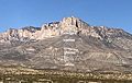
View from U.S. Highway 62/180
|
|
| Highest point | |
| Elevation | 8,064 ft (2,458 m) |
| Prominence | 285 ft (87 m) |
| Parent peak | Guadalupe Peak |
| Geography | |

El Capitan
Location in Texas
|
|
| Parent range | Guadalupe Mountains |
| Topo map | Guadalupe Peak |
| Geology | |
| Age of rock | Permian |
| Climbing | |
| Easiest route | Hike |
El Capitan is a tall peak in Culberson County, Texas. It is located inside Guadalupe Mountains National Park. This peak is one of the highest in Texas, standing 8,085 feet (2,464 meters) tall.
El Capitan is part of the Guadalupe Mountains. These mountains are actually an old reef from the Permian period. That was about 290 million years ago! Earth movements later pushed this ancient reef up. This made it visible during the late Cretaceous period (about 80 million years ago). El Capitan is at the southern end of the Guadalupe Mountains. Its huge size and unique shape make it a famous landmark in the Trans-Pecos region. Many travelers on U.S. Highway 62/180 have admired it for generations.
Contents
How El Capitan Was Formed
El Capitan is the southernmost part of the Guadalupe Mountains. These mountains are made from an ancient limestone reef. This reef was once part of the Capitan Reef Barrier. It was a huge reef, about 350 miles long. It was built mostly by sponges and algae.
This reef surrounded the Delaware Sea. This was an inland ocean that covered parts of Texas and New Mexico. This happened during the Permian period. Over time, the sea began to dry up. This left behind layers of salt and other minerals. These layers eventually covered the reef.
The Capitan Reef stayed buried for over 150 million years. Then, about 80 million years ago, the Earth's plates moved. This caused the land to push up. It created a large crack in the ground called the Border Fault. This movement exposed the Guadalupe Mountains. You can see how much the land moved by looking at El Capitan. It towers high above the flat salt lands next to it. After the reef was exposed, wind and rain slowly wore away the softer rock. This revealed the steep limestone walls of the Guadalupe Mountains.
People and El Capitan
The area around El Capitan is a rugged desert. Because of this, most Native American groups lived near Pine Springs. This area is about 3 miles southeast of El Capitan. Pine Springs had water and plants, like an oasis. People lived here for many centuries.
The Mescalero Apache used this area as a seasonal home. They knew where to find water and food in the harsh desert. They lived here until the 1800s.
Early Explorers and Travelers
Spanish explorers came close to El Capitan in the late 1500s. But permanent European presence started in the late 1840s. This was after the Mexican–American War. The United States wanted to find a good path from San Antonio to El Paso.
In 1849, Robert S. Neighbors led an expedition. They found a route through Guadalupe Pass. This path offered good water and timber. It became known as the "upper" road. Many traders and settlers used this road. Their wagons passed near El Capitan.
In 1858, the Butterfield Stagecoach started using this road. They built a station at Pine Springs. This station was used by soldiers and travelers for many years.

The El Paso Salt War
El Capitan also saw the El Paso Salt War. This was a fight over access to salt flats. These flats are west of the mountain. For centuries, Mexican and Mexican-American families collected salt here for free. It was important for their local economy.
In the 1870s, some businessmen tried to claim the salt flats. Local residents strongly opposed this. The conflict became violent in 1877. This led to many Mexican-American families leaving the area. In the end, the salt flats were claimed. Local people then had to pay for salt that had been free for generations.
A National Park Is Born
By the early 1900s, a road connected El Paso and Carlsbad, New Mexico. This road became U.S. Highway 62 in 1928. It brought new visitors to the area. Many people stopped to see El Capitan.
The land around El Capitan was owned by James Adolphus Williams. Later, it was sold to Judge J.C. Hunter in 1941. Hunter was an oilman and an early conservationist. He wanted to protect the Guadalupe Mountains.
After Hunter's death in 1945, his son, J.C. Hunter, Jr., continued his work. He worked with the National Park Service. They wanted to buy the land for a national park. After many years, the land, including El Capitan, was given to the Park Service in 1969. Three years later, Guadalupe Mountains National Park officially opened. This allowed the public to visit this amazing area.
Visiting El Capitan
El Capitan is located inside Guadalupe Mountains National Park. You can find the park on U.S. Highway 62/180. It is between Carlsbad and El Paso.
El Capitan has steep cliffs on three sides. These cliffs are rarely climbed because the rock is unstable. There is no direct trail to the very top of El Capitan. However, hikers can reach the summit. First, they climb near the top of Guadalupe Peak using the Guadalupe Peak Trail. Then, they can hike down to a saddle between the two peaks. From there, they can hike up the back of El Capitan to its summit.
- El Capitan from the Handbook of Texas Online
Images for kids
-
Labeled strata making El Capitan

See also
 In Spanish: El Capitán (Texas) para niños
