McKittrick Canyon facts for kids
Quick facts for kids McKittrick Canyon |
|
|---|---|

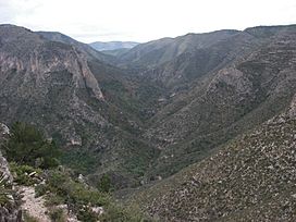
South McKittrick Canyon from the Notch
|
|

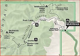
Map of McKittrick Canyon and hiking trails
|
|
| Floor elevation | 4,997 feet (1,523 m) |
| Long-axis direction | East-West |
| Area | 5,632 acres (2,279 ha) |
| Depth | 3,200 feet (980 m) |
| Geology | |
| Age | 12 million years |
| Geography | |
| Location | Culberson County, Texas, and Eddy County, New Mexico, United States |
| Topo map | USGS Guadalupe Peak, El Paso Gap |
| Traversed by | McKittrick Canyon Trail |
| Rivers | McKittrick Creek |
|
McKittrick Canyon Archeological District, Guadalupe Mountains National Park
|
|
| Location | Address restricted |
| Nearest city | Salt Flat, Texas |
| Area | 411 acres (166 ha) |
| NRHP reference No. | 91001381 |
| Added to NRHP | September 26, 1991 |
McKittrick Canyon is a beautiful canyon located in West Texas and Eddy County, New Mexico. It is famous for its tall, steep walls that protect a green, watery area, known as a riparian oasis. This special place is found right in the middle of the dry Chihuahuan Desert.
Most of McKittrick Canyon is part of Guadalupe Mountains National Park. It's a "day-use only" area, meaning you can visit during the day but not stay overnight. A big part of the northern canyon is in the Guadalupe Ranger District of Lincoln National Forest in New Mexico. You can reach McKittrick Canyon by driving 4.2 miles (6.8 km) on a special road from U.S. Route 62/180. Here, the National Park Service has a parking lot, restrooms, and a visitor center. Volunteers often work at the visitor center to help guests.
Contents
Exploring McKittrick Canyon Trail
The McKittrick Canyon Trail starts at the visitor center. It first follows a dry stream bed, crossing it many times as it goes deeper into the canyon.
Desert Plants Along the Trail
At the beginning of the trail, you will see plants typical of the Chihuahuan Desert. These include different kinds of yucca, agave, and cacti. Some common plants are Spanish dagger (Yucca faxoniana), sotol (Dasylirion leiophyllum), ocotillo (Fouquieria splendens), and lechuguilla (Agave lechuguilla). You might also spot century plants (Agave americana), prickly pear (Opuntia spp.), and claret cup cacti (Echinocereus triglochidiatus).
Among these desert plants, you will find a few strong pines and junipers. There is also the unusual Texas madrone (Arbutus xalapensis). This tree has red bark that curls up and peels off every year.
Water and Colorful Trees
As you go further up the canyon, the air becomes cooler and more sheltered. Here, a clear stream of water appears. More plants that love water, called riparian vegetation, start to grow. These include trees like oak, ash, and bigtooth maple (Acer grandidentatum).
In the fall, McKittrick Canyon becomes very colorful. The leaves of the maple and other hardwood trees change to bright reds, oranges, and yellows. This creates a beautiful contrast with the surrounding Chihuahuan Desert.
Wallace Pratt's Legacy
About 2.4 miles (3.9 km) into the trail, you will reach the Wallace Pratt Lodge. This lodge was built by Wallace Everette Pratt (1885-1981). He was a geologist who studied oil and gas, and he used to own most of McKittrick Canyon.
In 1959, Mr. Pratt gave 4,988 acres (2,019 ha) of his ranch to the National Park Service. Seven years later, in 1966, President Lyndon B. Johnson signed a law that created Guadalupe Mountains National Park. The park officially opened to the public in 1972.
Climbing to The Notch
Further up the canyon, the path gets very steep. It starts to follow a series of "switchbacks," which are zig-zag turns that help you climb a steep hill. The trail climbs almost 2,000 feet (610 m) over the next 2 miles (3.2 km).
Eventually, you will reach a high point called "the Notch." It is about 7,200 feet (2,195 m) high. From here, you can see amazing views of McKittrick Canyon and the desert far away to the east. You can also see South McKittrick Canyon to the west.
Historical Importance
A part of McKittrick Canyon is important for its history. It was listed on the National Register of Historic Places on September 26, 1991, because of its archeological importance. This means that ancient human sites and artifacts have been found there.
 | William Lucy |
 | Charles Hayes |
 | Cleveland Robinson |


