
Ward Valley (California) facts for kids
Quick facts for kids Ward Valley (California) |
|
|---|---|
Danby Dry Lake in south region of Ward Valley, from the Iron Mountain Pump Plant
|
|

Ward Valley (California)
Location in California
|
|
| Floor elevation | 709 ft (216 m) |
| Length | 55 mi (89 km) |
| Width | 9 mi (14 km) |
| Geography | |
| Population centers | Milligan, CA; Mountain Springs Summit, California; Goffs, CA; Rice, CA |
| Borders on | Old Woman Mountains-W Piute Mountains-W & NW Sacramento Wash (California)-N Bigelow Cholla Garden Wilderness-NE Sacramento Mountains (California)-ENE Stepladder Mountains-E Turtle Mountains (California)-E & SE Rice Valley & Arica Mountains-SSE Granite Mountains (California)-S & SSW Iron Mountains (California)-SW Cadiz Dunes Wilderness-SW & W |
Ward Valley is a long valley in the eastern part of San Bernardino County, California. It runs mostly from north to south.
The southern end of the valley spreads out a bit and holds Danby Dry Lake. This is a large, 13-mile (21 km) long dry lake or playa. A dry lake is a flat area where water collects after rain but then dries up, leaving behind a flat, often salty, surface. Mountains surround Ward Valley on all sides.
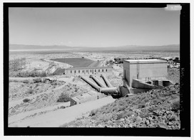
To the east, over the mountains, are other valleys like Chemehuevi Valley, Vidal Valley, and Rice Valley. These valleys all lead towards the Colorado River, which flows south. The middle of Ward Valley is located just east of the Oro Plata Mine, near the Old Woman Mountains. The Iron Mountains are on the southwest side of the valley. Here you can find the Iron Mountain Pump Plant, which is part of the Colorado River Aqueduct. This aqueduct is a huge system of canals, pipes, and pumps that brings water from the Colorado River to cities in Southern California.
Understanding Ward Valley's Location
The map of California shows where Ward Valley is located. It also highlights the lower, green valleys to the south. This area includes three dry lake beds, from west to east: Bristol Lake, Cadiz Dry Lake, and Danby Lake.
The Desert Environment
Ward Valley is a special place where two big deserts meet. It's a transition area between the higher parts of the Mojave Desert and the lower parts of the Mojave Desert. It also connects to the northwest part of the Sonoran Desert in southeast California, which is called the Colorado Desert.
This region has many dry mountain ranges and flat areas. You can also find bajadas, which are gentle slopes made of rock and gravel that form at the base of mountains. There are also sand dunes, created by strong winds, and playas, which are the flat, salty areas left by dry lakes.
Water Flow in the Valley
The long northern part of Ward Valley is mainly drained by a wash called Homer Wash. A wash is a dry streambed that only carries water after heavy rain. Because there isn't much rainfall, Homer Wash doesn't reach Danby Lake. Instead, its water sinks into the ground about 5 miles (8 km) north of the lake.
